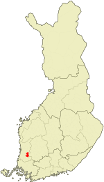
Kokemäki
| Kokemäki | ||
|---|---|---|
| Town | ||
| Kokemäen kaupunki | ||
| ||
 | ||
| Coordinates: 61°15.5′N 022°21′E / 61.2583°N 22.350°ECoordinates: 61°15.5′N 022°21′E / 61.2583°N 22.350°E | ||
| Country | Finland | |
| Region | Satakunta | |
| Sub-region | Pori sub-region | |
| Charter | 1869 | |
| Market town | 1972 | |
| Town privileges | 1977 | |
| Government | ||
| • Town manager | Markus Ojakoski | |
| Area(2011-01-01)[1] | ||
| • Total | 531.27 km2 (205.12 sq mi) | |
| • Land | 481.23 km2 (185.80 sq mi) | |
| • Water | 50.04 km2 (19.32 sq mi) | |
| Area rank | 220th largest in Finland | |
| Population (2013-08-31)[2] | ||
| • Total | 7,923 | |
| • Rank | 134th largest in Finland | |
| • Density | 16.46/km2 (42.6/sq mi) | |
| Population by native language[3] | ||
| • Finnish | 98.6% (official) | |
| • Swedish | 0.1% | |
| • Others | 1.3% | |
| Population by age[4] | ||
| • 0 to 14 | 14.3% | |
| • 15 to 64 | 62.3% | |
| • 65 or older | 23.4% | |
| Time zone | EET (UTC+2) | |
| • Summer (DST) | EEST (UTC+3) | |
| Municipal tax rate[5] | 19.75% | |
| Website | www.kokemaki.fi | |
Kokemäki (Swedish: Kumo) is a town and municipality of Finland.
It is located in the province of Western Finland and is part of the Satakunta region. The town has a population of 7,923 (31 August 2013)[2] and covers an area of 531.27 square kilometres (205.12 sq mi) of which 50.04 km2 (19.32 sq mi) is water.[1] The population density is 16.46 inhabitants per square kilometre (42.6 /sq mi).
The municipality is unilingually Finnish.
Kauvatsa municipality merged Kokemäki in 1969. These same towns and municipalities are also Satakunta Kokemäki tax-office in the area. Agricultural research center located in the Järilä’s village the years 1929-1996. Kokemäki town council decided on 15 December 2008 annexation with Nakkila, Harjavalta and Ulvila, but the project failed Ulvila amended decision.
Because of the central location and the old settlement of Kokemäki, it has historically been the major central area. In Kokemäki there are relics from the Iron Age and Middle Ages. Historical province of Satakunta was often called Kokemäki estates county in the later Middle Ages.
Through Kokemäki flows a 121-km-long river called Kokemäenjoki. Kokemäenjoki area is the fourth largest in Finland. Kolsi’s hydroelectric power plant is located in Kokemäki.
History
The legend says that in 1156 Saint Henry visited Satakunta on a preaching tour as a part of Erik the Holy’s first crusade to Finland. Kokemäki church has been founded in 1200 century maybe even earlier. Kokemäki estates county has been know from the year 1331 and its centre Kokemäki kings estate was hosted by the bishop of Turku and many royal families for a long time. There has also been a medieval castle in Kokemäki that was destroyed in 1367.
Kokemäki worked as administrative center of historic Satakunta in the Middle Ages. Province court was held in the court hill which was located near the Kokemäkis church and county seal kept close in the Ylistaro village still of the 1500s.
Medieval Huovintie goes from Turku by Kokemäki to Kokemäenjoki. On Huovintie was spiritual and secular community kept up guild houses where travelmen can stay overnight. This was located also near the Kokemäkis church. Kokemäenjoki has been important waterway to sea. Also it has been famous of salmons, whitefishes and lampreys.
Education
Kumo in the network of schools in recent years has reduced the basic classes 1 to 6 giving the schools have been closed. Remaining are High ditch school, Lähteenmäki’s school, Peipohja School, Riste’s school, Tulkkila’s school and Tuomaala’s school. Tulkkila’s school center buildings are used by middle school classes 7 to 9, special education, high school, and Kumo it’s adult line, as well as Kumo Community College.
Vocational training to provide training Hundred municipality group of Sata-Edu advantage Kumo unit. Its classrooms are located Peipohja. Huittinen professional and entrepreneurial university facilities are located in the north of Arden Children Kuoppala and college teaching kindergarten acquired Karimaa The garden is located in roast.
Tourist attractions
International relations
Twin towns — Sister cities
Kokemäki is twinned with:
References
- ↑ 1.0 1.1 "Area by municipality as of 1 January 2011" (PDF) (in Finnish and Swedish). Land Survey of Finland. Retrieved 9 March 2011.
- ↑ 2.0 2.1 "VÄESTÖTIETOJÄRJESTELMÄ REKISTERITILANNE 31.8.2013" (in Finnish and Swedish). Population Register Center of Finland. Retrieved 15 September 2013.
- ↑ "Population according to language and the number of foreigners and land area km2 by area as of 31 December 2008". Statistics Finland's PX-Web databases. Statistics Finland. Retrieved 29 March 2009.
- ↑ "Population according to age and gender by area as of 31 December 2008". Statistics Finland's PX-Web databases. Statistics Finland. Retrieved 28 April 2009.
- ↑ "List of municipal and parish tax rates in 2011". Tax Administration of Finland. 29 November 2010. Retrieved 13 March 2011.
External links
![]() Media related to Kokemäki at Wikimedia Commons
Media related to Kokemäki at Wikimedia Commons
- Town of Kokemäki – Official website (Finnish)
| ||||||||||||||

