Kohimarama
- for the Solomon Islands village see Kohimarama, Guadalcanal
| Kohimarama | |
|---|---|
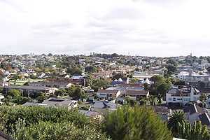
 Part of the suburb from the eastern headland. | |
| Basic information | |
| Local authority | Auckland City |
| Population | 6,339 |
| Facilities | |
| Surrounds | |
| North | (Hauraki Gulf) |
| Northeast | (Hauraki Gulf) |
| East | St Heliers |
| Southeast | Glen Innes, Glendowie |
| South | St Johns |
| Southwest | Meadowbank |
| West | Mission Bay |
| Northwest | Mission Bay |

Kohimarama is a coastal residential Auckland City suburb, located to the east of the city.
Situated in Eastern Auckland and has a reputation as being relatively wealthy, with many of the homes having some of the best views over Auckland Harbour. According to the 2001 census, Kohimarama has a population of 6,339. Kohimarama is home to two primary and one secondary school: St Thomas' School, Kohimarama School, and Selwyn College, which has a student population of over 1,000. Conveniently located Catholic schools include St Peter's College and Baradene College of the Sacred Heart.
History of Kohimarama
It was originally known as Mission Bay, a name now given to a neighbouring suburb.[citation needed]
Association football
The football (soccer) club Eastern Suburbs AFC who compete in the Lotto Sport Italia NRFL Division 1 are based in Kohimarama.
Gallery
-

Kohimarama Image:Kohimarama & Tamaki Drive.jpg|Kohimarama beach and Tamaki Drive
-
Sunrise on 1 May 2009
References
- The Lively Capital, Auckland 1840-1865, Una Platts. Avon Fine Prints Limited New Zealand 1971.
Coordinates: 36°51′33″S 174°50′45″E / 36.859074°S 174.845808°E
