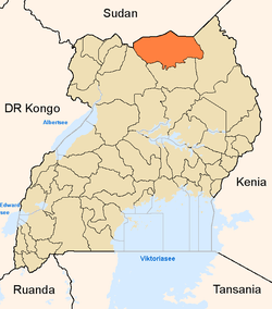
Kitgum District
| Kitgum District | |
|---|---|
| District | |
 | |
| Coordinates: 03°13′N 32°47′E / 3.217°N 32.783°E | |
| Country |
|
| Region | Northern Uganda |
| Sub-region | Acholi sub-region |
| Capital | Kitgum |
| Population (2010 Estimate) | |
| • Total | 220,000 |
| Time zone | EAT (UTC+3) |
| Website | Homepage |
Kitgum District is a district in Northern Uganda. It is named after its 'chief town' of Kitgum, where the district headquarters is located. It has suffered many deaths and social disruption resulting from the 20-year civil war within the region during the late 20th century. The government moved tens of thousands of residents were moved to internally displaced persons camps for their protection, where they were subject to raids by the rebels and also harsh conditions, including disease.
Location
Kitgum District is bordered by South Sudan to the north, Kaabong District to the east, Kotido District to the southeast, Agago District to the south, Pader District to the southwest and Lamwo District to the northwest.[1] The coordinates of the district are: 03 13N, 32 47E (Latitude:3.2222; Longitude:32.7777). Kitgum, the largest town in the district, is located approximately 452 kilometres (281 mi), by road, north of Uganda's capital, Kampala.[2] The district is composed of one county: Chua County. In 2010, Lamwo County was separated from Kitgum District to form Lamwo District. Kitgum District is a constituent part of Acholiland, home to an estimated 1.1 million Acholi, according the 2002 national census. The other six districts in the Acholi sub-region are:
Population
According to the Ugandan national census of 2002, Kitgum District, as constituted in 2011 had a population of 167,030, of whom 51.3% were females and 48.7% were males. Most are ethnic Acholi, who are Luo speaking. The annual population growth rate of the district was estimated at 3.5%. With those statistics, it is estimated that the population of the district in 2010, was approximately 220,000. See table below:
| Kitgum District Population Trends | |||||||||||||||||||||||||||||||||||
Economic activitiesAgriculture is the main economic activity in the district. Crops grown include: [3][4]
Cattle ranching is practiced in some areas, although not widely. Hepatitis epidemicDuring late 2007 and early 2008, as many of the residents of the Internally Displaced Persons (IDP) camps started to return to their home areas following peace talks, an outbreak of Hepatitis E engulfed the community, and soon spread to the entire district. As of August 2008, a total of 8,157 cases had been identified; 62% were female, while 38% were male. The case fatality ratio was 1.52%. Seventy two percent (72%) of the fatalities were female. The epidemic has been traced to unsanitary sources of drinking water.[5] By July 2009, the number of infected persons had increased to 10,243, of whom 162 died; a case fatality ratio of 1.58%.[6] Notable peoplePlus-size model Sunday Omony was born in the Kitgum District.[7] See also
References
External links
| |||||||||||||||||||||||||||||||||||