Kirchhain
| Kirchhain | ||
|---|---|---|
 | ||
| ||
 Kirchhain | ||
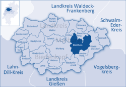
Location of Kirchhain within Marburg-Biedenkopf district  | ||
| Coordinates: 50°49′N 8°55′E / 50.817°N 8.917°ECoordinates: 50°49′N 8°55′E / 50.817°N 8.917°E | ||
| Country | Germany | |
| State | Hesse | |
| Admin. region | Gießen | |
| District | Marburg-Biedenkopf | |
| Founded | 1146 (first mentioned) | |
| Subdivisions | 13 Stadtbezirke | |
| Government | ||
| • Mayor | Jochen Kirchner (Ind.) | |
| Area | ||
| • Total | 90.92 km2 (35.10 sq mi) | |
| Elevation | 208 m (682 ft) | |
| Population (2012-12-31)[1] | ||
| • Total | 16,145 | |
| • Density | 180/km2 (460/sq mi) | |
| Time zone | CET/CEST (UTC+1/+2) | |
| Postal codes | 35274 | |
| Dialling codes | 06422 | |
| Vehicle registration | MR | |
| Website | www.kirchhain.de | |
Kirchhain is a town in Marburg-Biedenkopf district in Hesse, Germany.
Geography
Kirchhain is located in the heart of the state of Hesse in Marburg-Biedenkopf County. Geographically, it is surrounded by the Amöneburg Basin on the southeast edge of the Burgwald (a low mountain range) about 15 km east of Marburg on the rivers Ohm and Wohra.
Neighbouring communities
In the north, Kirchhain borders on the town of Rauschenberg, in the east on the town of Stadtallendorf, in the south on the town of Amöneburg and the community of Cölbe (all Marburg-Biedenkopf communities).
Town divisions
Besides the main centre of Kirchhain with about 8,300 inhabitants, 12 further constituent communities share another 8,900 people:
|
|
History
In prehistoric times a network of long-distance and connecting trails crossed back and forth over the area where the town of Kirchhain was later to be founded. Since the early New Stone Age, there is evidence of almost continuous settlement in the area through various epochs. The high point of the expansion of settlement was in the early Iron Age (5th century BC). The first territorial development however began only in the 12th century; in 1146 the settlement was first mentioned in a document under the name "Werphloh". The region belonged at that time to the landgravates of Thuringia and Hesse, whereas the neighbouring Amöneburg and vast parts of the surrounding lands belonged to the Archbishops of Mainz. Time and again, the Hessians and Mainzers came to blows over who had ascendancy over these lands. As of the 13th century, the landgraves of Hesse further upgraded Kirchhain as a Hessian bulwark against Mainz's centre of Amöneburg so that they could control the region. Kirchhain then developed into the economic centre of the Amöneburg Basin. Kirchhain was presumably given town rights before 1348, but without any earlier documentary proof, the year 1352 has come to be seen as the official year of the town's founding.
From the 15th century, the important Lange Hessen and Cologne-Leipzig trade roads made of Kirchhain a road hub and thereby spurred on the town's further economic development. Its good traffic connections, however, led to Kirchhain's being occupied a few times during the Thirty Years' War, becoming for a time the headquarters of various armies, and thereby having to suffer as troops were billeted in the town. In 1636, about 12,000 to 14,000 soldiers were being housed in and around the town. For the 1,000 or so townsfolk at that time, this was a tremendous burden.
Kirchhain likewise had to put up with such troubles in the Seven Years' War as its good traffic connections once again led troops to the town.
From 1821 on, Kirchhain was the district seat (Kreisstadt) of the newly created Kirchhain administrative district, until this was combined with the Marburg district in 1932.
Politics
Town council
As of municipal elections held on 26 March 2006, seats on town council are apportioned thus:
| CDU | 15 seats |
| SPD | 15 seats |
| Greens | 4 seats |
| FDP | 2 seats |
| UWG (citizens' coalition) | 1 seat |
Town partnerships
-
 Plomelin, Brittany, France (since 1966)
 -
 Doberlug-Kirchhain, Brandenburg (since 1989)
Buildings
- Town Hall (Rathaus), the town's landmark, built about 1450 with timber framing.
- The Haus „Zum blauen Löwen“, built 1612, birth house of the poet Eberhard Werner Happel
- Evangelische Stadtkirche St. Michael, a 15th-century church
- Transformatorenhäuschen in the borough Anzefahr
Sons and daughters of the town
- Eberhard Werner Happel (1657–1690), Poet
- Leo Strauss (1899–1973), Philosopher
- Wilhelm Noll (1926- ), Motorcycle-sidecar world champion
- Benedict Stilling Benedict Stilling (1810-1879), Surgeon
References
- ↑ "Die Bevölkerung der hessischen Gemeinden". Hessisches Statistisches Landesamt (in German). July 2013.
- This article incorporates information from the German Wikipedia.
External links
| Wikimedia Commons has media related to Kirchhain, Germany. |
| |||||||
