Kingston-On-Murray, South Australia
From Wikipedia, the free encyclopedia
| Kingston-On-Murray South Australia | |
|---|---|
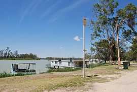
 Houseboats on the Murray River | |
 Kingston-On-Murray | |
| Coordinates | 34°13′0″S 140°20′0″E / 34.21667°S 140.33333°ECoordinates: 34°13′0″S 140°20′0″E / 34.21667°S 140.33333°E |
| Population | 257 (2006)[1] |
| Postcode(s) | 5331 |
| Location | |
| LGA(s) | District Council of Loxton Waikerie |
| State electorate(s) | Chaffey |
| Federal Division(s) | Barker |
Kingston-On-Murray is a town on the south bank of the Murray River in the Riverland region of South Australia. It was named after Charles Kingston who was Premier of South Australia from 1893-99. At the 2006 census, the town had a population of 257.[1]
The Sturt Highway now bypasses the town and crosses the Murray River over a bridge. Before the bridge was built in the 1970s, there were two vehicular cable ferries in the town to carry traffic over the river.
Kingston-On-Murray is in the District Council of Loxton Waikerie, the state electoral district of Chaffey and the federal Division of Barker.
References
| Wikimedia Commons has media related to Kingston-On-Murray, South Australia. |
- ↑ 1.0 1.1 Australian Bureau of Statistics (25 October 2007). "Kingston On Murray (State Suburb)". 2006 Census QuickStats. Retrieved 2010-01-22.
| |||||
This article is issued from Wikipedia. The text is available under the Creative Commons Attribution/Share Alike; additional terms may apply for the media files.