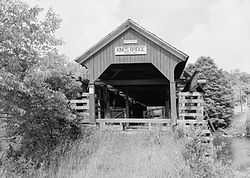
King's Bridge
From Wikipedia, the free encyclopedia
This article is about the bridge in Pennsylvania. For places named Kingsbridge, see Kingsbridge (disambiguation) .
|
King's Bridge | |
 | |
|
King's Bridge, June 2005 | |
 | |
| Location | West of Somerset off Pennsylvania Route 653, Middlecreek Township, Pennsylvania |
|---|---|
| Coordinates | 39°56′15″N 79°16′17″W / 39.93750°N 79.27139°WCoordinates: 39°56′15″N 79°16′17″W / 39.93750°N 79.27139°W |
| Area | 0.1 acres (0.040 ha) |
| Built | 1806 |
| Architectural style | Other, Kingpost truss |
| Governing body | Local |
| MPS | Covered Bridges of Somerset County TR |
| NRHP Reference # | 80003632[1] |
| Added to NRHP | December 11, 1980 |
The King's Bridge is a historic covered bridge in Middlecreek Township, Somerset County, Pennsylvania. It was built in 1806, and is a 127-foot-4-inch-long (38.81 m) Burr truss bridge, with an asbestos covered gable roof. The bridge crosses Laurel Hill Creek. It is one of 10 covered bridges in Somerset County.[2]
It was added to the National Register of Historic Places in 1980.[1]
See also
References
- ↑ 1.0 1.1 "National Register Information System". National Register of Historic Places. National Park Service. 2010-07-09.
- ↑ ""National Historic Landmarks & National Register of Historic Places in Pennsylvania"" (Searchable database). CRGIS: Cultural Resources Geographic Information System. Note: This includes Herb Berman and Susan M. Zacher (undated). "National Register of Historic Places Inventory Nomination Form: Covered Bridges of Somerset County Thematic Resources (King's Bridge)" (PDF). Retrieved 2011-12-08.
External links
- Historic American Engineering Record (HAER) No. PA-638, "King's Bridge", 5 photos, 2 data pages, 1 photo caption pages
| ||||||||||||||||||||
This article is issued from Wikipedia. The text is available under the Creative Commons Attribution/Share Alike; additional terms may apply for the media files.
