Kilteel
| Kilteel Cill Chéile | |
|---|---|
| country | |
 Kilteel | |
| Coordinates: 53°14′06″N 6°31′26″W / 53.235°N 6.524°W | |
| Province | Leinster |
| County | County Kildare |
| Elevation | 243.8 m (799.9 ft) |
| Population (2011) | |
| • Urban | 225 |
| Time zone | WET (UTC+0) |
| • Summer (DST) | IST (WEST) (UTC-1) |
| Historical population | ||
|---|---|---|
| Year | Pop. | ±% |
| 1841 | 923 | — |
| 1851 | 676 | −26.8% |
| 1871 | 477 | −29.4% |
| 1901 | 268 | −43.8% |
| 1951 | 181 | −32.5% |
| 2002 | 483 | +166.9% |
| [1] | ||
Kilteel (Irish: Cill Chéile) is the name of a townland, civil parish and village located in County Kildare, Ireland in the Barony of South Salt. The townland and village contain the ruins of both a Romanesque church and a 13th-century preceptory of the Knights Hospitaller in addition to a well-preserved 15th-century tower house. The settlement is located on the southwest corner of the English Pale and served an important function as a border fortresss during the medieval period.
Geography
The village of Kilteel is located on a low northeast-southwest ridge at the western edge of the Wicklow Mountains. The civil parish covers 3437 statute acres and contains the following townlands:
| Townland | Acreage | Irish Name |
|---|---|---|
| Blackchurch | 229 | - |
| Blackdown | 151 | - |
| Coolahocka | 119 | - |
| Cromwellstown | 240 | - |
| Cupidstown | 301 | - |
| Kilteel Lower | 259 | - |
| Kilteel Upper | 210 | - |
| Kilwarden | 364 | - |
| Newrow | 70 | - |
| Oldmiltown | 165 | - |
| Oldtown | 21 | - |
| Porterstown | 98 | - |
| Rathbane | 447 | -[2] |
The parish extends from the peak of Cupidstown Hill adjoining County Wicklow to the southeast, east to Cromwellstownhill where it borders Dublin County. To the north, west and south it borders with the Kildare parishes of Oughterard, Kill and Rathmore. The N7 crosses the townland of Blackchurch at the northern extent of the parish.
History
Prehistory and Early Medieval Period
The Record of Monuments and Places suggests a prehistoric barrow located northwest of the modern village may have functioned as an inauguration site.[3][4] The Ordnance Survey Placenames Commission identifies the original name as Cill Chéile or Cell Chéile.[5] A monastery was reputedly founded here by Celé Crist, who died in 721.[6][7] Excavations of the medieval church identified an 8th-century phase. An Early medieval D-shaped enclosure and a range of associated industrial features were also excavated in Blackchurch townland in 2004.[8] The townland name Rathbane, anglicised as Whitefort, suggests the presence of an early medieval ringfort, though no such site has yet been identified within the townland.[9]
Medieval Period
- Romanesque church
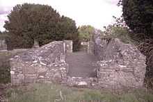
A ruined church with the decorated piers of a Romanesque chancel arch survives to the southwest of the village. Excavation of the church in 1977–78 dated the earliest structural elements remains to the 7th and 8th centuries with extensive additions in the 12th century. The carved Romanesque figures contained in the chancel arch include representations of Adam and Eve, David and Goliath and Samson. The church was rebuilt during the medieval period, became ruinous in the 16th century, was restored in the 17th century, and subsequently fell into disuse.[10][11][12] The decorated fragments of the chancel arch were recovered from the fabric of a farmhouse adjoining the castle and reinstated in 1935.[13] Fragments of a 12th-century sandstone High Cross survive to the north of the church.[14][15]
- Hospitaller preceptory
The priory of the Knights Hospitallers at Kilmainham founded a preceptory here before 1212.[16] No foundation charter or original grant of land survives, but the prior of the preceptory is referred to in the Justiciary Rolls of 1308.[17] The preceptory was one of only seventeen in Ireland. General chapters of the order were held in Kilteel in 1326, 1333 and 1334.[18] The surviving remains include traces of a large sub-rectangular earthen enclosure, 200 metres long and 150 metres wide, possibly the original enceinte, a substantial gatehouse containing a guardroom and the ruins of a second gatehouse.[19] A suit of armour was recovered from the ruins in the early 19th century.[20]
- Pale boundary
Kilteel occupied an important position as a border fortress on the marches of the English Pale under attack from the Gaelic O'Byrne and O'Toole families of Wicklow. In 1355 Edward III issued letters requiring those appointed for the defence of the marches to take up their duties in the wards of Kilteel, Rathmore and Ballymore. Similar letters chastising those who had failed to take up their duties in Tallaght and Bray note the 'depredations and burnings of Obryn and his accomplices' .[21] An act of the Irish Parliament of 1488 setting out the boundaries of 'the four obedient shires' of Louth, Meath, Dublin and Kildare describes the 'new ditch' forming the Pale boundary as passing through Kilteel and Rathmore.[22] A portion of this 15th-century earthen fortification is visible in aerial photographs a short distance southeast of the church.[23][24]
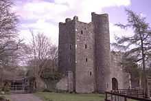
- Tower house
A substantial tower house was built to strengthen or replace the earlier defences in the 15th century. This rectangular, five-storied structure contains four floor levels above a barrel-vaulted basement with a second vault over fourth-floor level.[25][26] It is adjoined to the southwest by a gatehouse and was originally adjoined by a bawn.[27]
Early Modern Period
The Alen family of Norfolk obtained possession of a range of monastic property in Kildare after the dissolution of the monasteries. John Alen, later Lord Chancellor of Ireland, was granted the dissolved monastery of St. Wolstans in 1536. In 1539 his younger brother Thomas was granted the dissolved preceptory of Kilteel.[28][29] The troubled status of the area is reflected in a 1541 grant confirming his title:
| “ | In consideration that the Preceptory, lordship or manor of Kilheale, in Kildare county, is situated in the marches thereof near the Irish enemies, the Tholes (O'Tooles), where resistance and defence are required, grant to Thomas Alan and Mary his wife, the said lordship.[30] | ” |
A 1543 lease lists the possessions of the preceptory:
| “ | Lease to Thomas Alen of Kilester, of the manor of Kilheale, Cromwelleston, near Calliaghton, Kilwarnyng, near Castlewarnyng and Kilbride, near "The Three Castles" in the county of Dublin; Johnston, Rathmore, Sherlokeston and the Naas in the county of Kildare; all which came into the hands of the Crowne by the surrender of Sir John Rawson, Viscount of Clontarf, late Prior of the Hospital of Saint John of Jerusalem : to hold for 51 years. Rent, £6 13s. 4d - June 10. 34.[31] | ” |
Alen's wife, Mary, was the daughter of John Rawson.[29] The Alen family, whose primary seat was at St. Wolstans, adopted Kilteel as a second family seat in the 16th and early 17th century. In 1549 pardons were granted to John Alen of Alenscourte and Thomas Alen of 'Kylheale' , in 1560 and 1561 Thomas Alen of Kilteel was listed among the 'justices, commissioners and keepers of the peace' for Kildare and in 1626 Robert Allen, heir to the Alenscourt estates, was described as 'of Kilheale'.[32][33][34] The Allen family were still entitled to tithes from the parish in the 19th century.[35]
Kilteel was raided and burnt twice by Rory O'More in 1574.[36] In November 1580 during the Second Desmond Rebellion a force of 50 horseman and 100 foot soldiers were stationed at Kilteel to guard against the incursions of Fiach McHugh O'Byrne.[37] Fiach McHugh's son was stealing livestock from the 'mountain of Kilheele' in 1596.[38]
The Civil Survey of 1654–56, a survey of Catholic lands liable to confiscation after the Cromwellian conquest, records two divisions within the parish, Kilteel, 1540 plantation acres, and Kilwarning, 100 plantation acres. Other townlands are referred to in contemporary sources. In 1641 all lands in the parish were held by Robert Allen, an 'Irish papist'.[39] In 1654 the parish contained:
| “ | "One Castle...wch in the year 1640 was valued to be worth sixty pounds butt being since ruined is now valued at ffourty pounds....Two Mills wch in the year 1640 were valued to be worth Thirty pounds and ten shillings....one church and one decayd abbey....There is one stump of a castle called Blackchurche upon the Aforesaid lands of Kilwarneing...There is also one other ould castle upon the lands of Kilwarneing.[40] | ” |
The Archaeological Survey of Ireland notes the site of a 16th or 17th century house, location unidentified, within Blackchurch townland, presumably corresponding to one of the castles recorded in the Civil Survey.[41] The 1659 Census records 24 'Irish' and three 'English' living in Kilteel, five 'Irish' and two 'English' in Blackchurch, two 'English' and seven 'Irish' in Kilwarning. These figures represent an estimate of the population over 15, liable to poll-tax. A multiple of 2.5 can be applied to loosely estimate the total population.
Kilteel passed from the Alen family to Richard Talbot, Earl of Tyrconnell before 1669. Between 1669 and 1677 Tyrconnell leased out the Kilteel estate in several parcels: Jonathan Hayes and James Ashton held the 'millfarm' for 51 years from 1670; a 38 year lease of 'Porters-farme' to James Sharpe from 1670 passed to Daniel Reading before 1703; George Eaton held Cromwellstown for 39 years from 1670; William Palmer held a portion of Kilteel for 99 years from 1670 and in 1677 Thomas Cholmondley was granted a portion including the modern townland of Cupidstown for 51 years.[42]
Daniel Reading also held the lease of Kilteel Castle and a block of adjacent lands. After the Williamite Wars Tyrconnell was attainted and his lands were confiscated. The castle and 'Reading's farm, being part of Kilteele' encompassing 376 plantation acres, were purchased by the Hollow Sword Blade Company for £976 on 23 June 1703.[43] The castle was then sold to Sir William Fownes. In 1838 the estate was purchased from his heir, W.F. Fownes Tighe, by Sir John Kennedy. The castle was still in the possession of the Kennedy family in 1895.[44]
A Quaker community briefly flourished at Kilteel, possibly with the encouragement of Tyrconnell, who showed considerable sympathy towards the Quakers during the brief period of Catholic political ascendancy after the ascension of James II.[45] In 1678 James Ashton held the first Quaker meeting at his house in Kilteel. In 1704 'with the assistance of a few other friends in his neighbourhood' he built a Meeting House. The house was moved to Castlewarden in 1723.[46] In 1690 the Dublin Quaker community was administering relief to the Quaker community in Kilteel. In 1692 the Quaker Joshua Saunders of Kilteel was condemned for his relations with the servant of his father Thomas Saunders.[47] James Ashton's will of 1704 passed his share of the lease of the 'millfarm', and Kilwarden to his wife and daughter. His lease from Daniel Reading passed to his son, Thomas Ashton of Kilteel. Jonathan Hayes, described as a farmer of Millfarm, was a trustee of the will. The townland of Newrow may owe its name to Ashton or Hayes who held property in New Row, Dublin.[48] Thomas Cholmondley's holding of 178 plantation acres, 'alias Brians farme' , was bought by Joseph Maddock, a Quaker linen draper, on 2 June 1703.[49] Maddock's will of 1713 provided for the 'lands of Cupidstown together with Cholmondly's farm' to pass to his son Joseph.[50] In 1784 Mary Maddock granted a lease of the lands of Cupidstown, presumably with the modern townland of Cupidstownhill to Peter Fox, whose descendants held land there into the 19th century.[51][52]
Nineteenth and Twentieth Centuries
In 1766, Robert Green, vicar of the united parishes of Rathmore, Kilteel and Kilbride recorded five Protestant families and 33 Roman Catholic families within the parish of Kilteel.[53] In the 18th and 19th centuries the village had four annual fairs, on 1 May, 24 June, 29 September and 2 November.[54][55] The 1821 census estimated the population of the 'village' of Kilteel at 43 families, totalling 316 people in 36 houses.[56] In 1841 the civil parish contained 129 inhabited houses, declining to 112 inhabited houses in 1851.[57]
A National school, built in 1845, is recorded in the 1853 Primary Valuations and the 1911 Census and depicted on the Ordnance Survey maps, closed in 1968; the building, with the original datestone, survives adjacent to Brennan's Public House.[58][59] The school had 100 pupils in 1845.[60] A forge, recorded in the 1853 valuations but absent from the 1901 census, appears to have been located on the lane running northwest from the village.
'Old Mill' is marked as a placename on Noble and Keenan's 1752 map of Kildare. Presumably the mill was one of those noted in the Civil Survey of 1654–56 within the 'Millfarm' recorded in 1670.[61] The townland of Oldmilltown contains traces of the original millhouse and millrace depicted on the 1838 Ordnance Survey maps.
An Ordnance Survey trigonometrical station is located at the top of Cupidstownhill. Traces of a second station are visible within the prehistoric enclosure north of the village.[62]
A Royal Irish Constabulary barracks marked on the 1838 Ordnance Survey maps and recorded in the 1911 Census survives as a private dwelling.[63][64] A barracks was present from at least 1827, with one constable and three sub-constables in 1829.[65] In October 1920 the barracks came under attack during the Irish War of Independence; the officers were withdrawn to Naas and the building was burnt by the Kill Company of the Irish Republican Army.[66] A minor confrontation between Free State and Irregular forces took place at Kilteel in 1923 during the Irish Civil War.[67]
While the National Inventory of Architectural Heritage describes the Catholic church of St. Laurence O'Toole as dating from c. 1870, an Irish Times article of 1935 describes the construction and dedication of the chapel of ease in that year.[68][69] The church is not depicted on the 25 inch Ordnance Survey maps.[70]
Kilteel Wood, a small oak wood north of the village is depicted in its current location and extent on the 1838 Ordance Survey map.[71] The wood is a Proposed Natural Heritage Area (001394).[72]
Notable residents
- Marian Finucane, a broadcaster with Raidió Teilifís Éireann
Sport
- Sporting history
RIC records from 1890 show that Kilteel King O'Tooles club had 30 members.[73]
See also
- List of towns and villages in Ireland
- List of abbeys and priories in Ireland (County Kildare)
- List of castles in Ireland (County Kildare)
References
- ↑ http://ncg.nuim.ie/content/projects/famine/maps/pop/Kildare/
- ↑ http://www.thecore.com/seanruad/
- ↑ Record of Monuments and Places KD020-005: "A Registered Historic Monument. Shown as a circular feature in this general area on Taylor's Map of County Kildare (1783). Prominently sited on a wooded hilltop (OD 815 feet) with excellent views in all directions. A slightly raised, almost circular central area (diams. 25m E-W; 23m N-S; H 0.6-0.8m) has a small, low mound in its SW sector (diam 4.5m; H 0.6-0.7m), probably the remains of the Trigonometrical station shown on the OS 6-inch mapping, and is girdled by a broad, shallow fosse (Wth 6m), and a low outer bank (H 0.7m; Wth 2m). Intermittent traces of a possible second, narrow, shallow, outer fosse (Wth 1m; D 0.2m) may be a later feature. Some 4m to the SW, a large, roughly squared, stone block (dims. L 1.2m; Wth 1m; H 0.9m) appears to have been deliberately set in place, while two further, overgrown blocks to the SE are of uncertain significance. The monument may be a barrow which was subsequently modified for use as an inauguration site."
- ↑ http://maps.osi.ie/publicviewer/#V1,698231,721656,7,9
- ↑ http://logainm.ie/Viewer.aspx?text=kilteel&streets=yes
- ↑ Shearman, John Francis 1882. An Identification of Localities, Chiefly in Leinster, Visited by Saint Patrick and His Assistant Missionaries and of Some Contemporary Kings and Chieftains.Dublin. p. 192
- ↑ http://monasticon.celt.dias.ie/showrecord.php?id=2362
- ↑ http://www.excavations.ie/Pages/Details.php?Year=&County=Kildare&id=11725
- ↑ http://maps.osi.ie/publicviewer/#V1,699373,720613,6,7
- ↑ Manning, Conleth 1982. 'Excavations at Kilteel Church, Co. Kildare' in Journal of the County Kildare Archaeological Society, Volume XVI pp. 173-29
- ↑ Manning, Conleth. 1996. 'Kilteel Revisited' in Journal of the County Kildare Archaeological Society, Volume XVIII, pp. 297-300
- ↑ Record of Monuments and Places KD020-007002
- ↑ Leask, Harold 'Carved stones discovered at Kilteel, Co. Kildare' in JRSAI 65 (1935) 1-8.
- ↑ Record of Monuments and Places KD020-007005
- ↑ http://maps.osi.ie/publicviewer/#V1,698346,721334,7,9
- ↑ Barry, Terry 1989. The Archaeology of Medieval Ireland. Dublin. p. 162
- ↑ Wood, Herbert & Langman, Albert, 1956. Calendar of the Justiciary Rolls of Ireland:1308-1314. Dublin. Stationery Office - http://archive.org/stream/calendarofjustic03irel#page/44/mode/2up
- ↑ Litton Falkiner, C. 1907. ‘The Hospital of St. John of Jerusalem in Ireland’ in Proceedings of the Royal Irish Academy, Vol. 26 (1906–1907), pp 275-317, p. 310
- ↑ Record of Monuments and Places KD020-007003
- ↑ 'Kilteel Castle' in Dublin Penny Journal, No. 68, Vol. II, Oct. 19, 1833
- ↑ http://chancery.tcd.ie/roll/29-Edward-III/Patent
- ↑ D'Alton, John 1838. The History of the County of Dublin. Dublin. p. 34
- ↑ Record of Monuments and Places KD020-008: Description: "The area which would later be called 'The English Pale', from the Latin 'palus', a stake, and also possibly from the name of an earthen fortification at Calais in France (Lydon 1972, 261), originated in the 14th century when Norman settlers began fortifying their lands in counties Dublin, Kildare, Louth and Meath against attack by the native Irish. By 1435, ongoing attacks, probably primarily aimed at cattle theft (O'Riordáin 1971, 15), prompted the concept of an additional, linear defensive feature, the boundaries of which were defined in a 1488 Act of Parliament as extending, 'from Merrion inclusive to the waters of the Dodder, by the new ditch to Saggard, Rathcoole, Kilheel (Kilteel), Rathmore and Ballymore (Eustace), thence to the county of Kildare into Ballycutlan (Coghlanstown), Harristown and Naas, and so thence to Clane, Kilboyne, and Kilcock' (Mc Neill 1950, 250). In 1494, Parliament directed that, 'every inhabitant, earth tiller and occupier in said marches (borderlands), do build and make a double ditch six feet high above ground at one side or part which meareth next unto Irishmen between this and next Lammas (August 1st.), the said ditches to be kept up and repaired as long as they shall occupy said land.' However, Ellis (Ellis S. G. 'The emergence of the English Pale in Ireland' in Irish Historical Studies) points to a statute in Poyning's parliament in 1495 for 'ditches to be made aboute the Inglishe pale' as the first application of the term to Ireland. The Pale contracted eastwards in subsequent years and it is not certain if its original extent was ever completely ditched. By the 17th century the Pale had ceased to have any real political or defensive significance. Only a few short sections have been positively identified in Co Kildare; in Kilteel Upper/Cupidstown near Rathmore (KD020-008-----), in Bishopsland just SW of Ballymore Eustace (KD029-039----), at Castlebrown or Clongowes (KD010-021----/KD014-008----) and finally, the best preserved, semi-continuous portion which runs for c. 3365m through the townlands of Ballybrack, Ballyloughan, Clonduff, Clonfert South and Graiguepottle, c. 5km N of Clongowes (KD010-001----). In Kilteel Upper/Cupidstown, a 1966 aerial photograph (CUCAP APA 56) shows extensive earthworks around the early monastic foundation of 'Cell céli críst' (KD020-007002-) upon which a preceptory of Knights Hospitallers of St John of Jerusalem (KD020-007003-) was founded in the 13th century. Manning (1981–82, 213, 219) subsequently identified some of the earthworks which ran to the S and W of the preceptory as being part of the Pale Boundary (traceable L c. 1100m). The main line of the earthwork, to the S of the ecclesiastical remains, was a shallow ditch (Wth 3.5m; D 0.6m) with a broad, low earthen bank (Wth 6.5m; H 0.6m) 'outside', to S, and a low, earthen, bastion-like projection was also noted. A small, overgrown section of the earthwork c. 750m E of the ecclesiastical remains was subsequently excavated archaeologically as it lay on the line of the Cork-Dublin Gas-pipeline (O'Donnell 1987, 110; Cleary et al. 1987, 106-110). An earthen bank (H 1.27m; Wth 2m) had a shallow, 'outer' ditch (Wth 2.26m; D 0.23m) to SW, while second 'inner' ditch to NE had been recently recut. A palisade-trench (D 0.38m; Wth at top 0.34m; Wth at base 0.24m) was found running along the top of the bank."
- ↑ http://maps.osi.ie/publicviewer/#V1,698598,721052,7,0
- ↑ Record of Monuments and Places KD020-006 "Description: A National Monument (No. 275), standing at the W edge of the Kilteel Early Christain and medieval ecclesiastical complex (KD020-007001- to KD020-007012-), around which the Pale Ditch (KD020-008----) also runs, and associated both with a Preceptory of the Knights Hospitallers (KD020-007003-) and the subsequent defence of the Pale. On a narrow terrace near the top of the moderate, SE-facing slope of a minor valley through which a small stream flows SW, and overlooked by slightly higher ground WSW-N-NE. A probable 15th century, rectangular, five-storied, roofed structure (ext. dims. L 8.5m NE-SW; Wth 5.5m; av. wall T 1.05m) comprises four floor levels above a barrel-vaulted (NE-SW axis) basement with a second vault over fourth-floor level. Built of randomly coursed limestone blocks and flags with well-dressed quoins and voussoirs, it has a projecting D-shaped stairs tower (ext. diam. c. 3.2m; int. diam 1.6m) at the SW end of the NW sidewall, and is adjoined at SW by a gatehouse (KD020-006001-). The basement (int. dims. L 6.4m NE-SW; Wth 3.65m) is entered through a probably later doorway in the SW gable wall, and has a low, vaulted ceiling (H 2.1m). Lit by only two loops, with steeply plunging sills, flanking a probably inserted and now robbed-out fireplace in the NE gable wall, the basement contains wall-cupboards in the NW, SE and SW walls, and a small, stone drain near the SW end of the SE wall. A narrow (Wth 0.5m), square-headed doorway immediately to the left (NW) of the main doorway gives access to the spiral stairs in the projecting tower. A loop near ground level looks SW across the adjoining gate arch, and six more loops light the tower; a second near ground level and one at the top look NW, while in between, four loops in a vertical line look WNW. Plain, square-headed doorways give access off the stairs to the upper floors, and, from a cap house on the stairs tower, to wall-walk level. A doorway between first and second-floor levels gives access to the first floor of the adjoining gate house which is also accessed through doorways in the SW gable wall of the main building at second and third-floor levels. Floor levels are indicated by corbels in the NW and SE sidewalls and each floor is lit by plain, rectangular windows in large embrasures in each wall (some with window-seating), those in the NE and SE walls rising in a vertical line, one above the other. There are fireplaces and wall-cupboards on each floor, except the fourth. A former window in the NE gable wall on first-floor level was broken out to form a doorway, possibly to give access to a wall walk of a formerly adjoining bawn (KD020-006002-). The low, stone-slabbed, A-roof, the guttering and the crenelations have been restored and chimney stacks on the NW, NE and SE walls have been lowered and capped below crenelation height. In 2005, an archaeological assessment (Licence No. 05E0681: 'Excavations 2005' 2008, (No. 761) 186) and subsequent monitoring of topsoil removal in 2006 (Licence No. 06E2475, C159: 'Excavations 2006' 2009, (No. 965) 246) at a single-house development c. 80m SW of the monument uncovered some 20 sherds of pottery, 14 of which were medieval in date, including Leinster cooking ware, Dublin-type coarseware and Dublin-type fine ware, with the remainder being post-medieval date in date. (Killanin and Duignan 1967, 408; Harbison 1975, 123) Compiled by: Gearóid Conroy"
- ↑ http://maps.osi.ie/publicviewer/#V1,698311,721258,7,3
- ↑ Record of Monuments and Places KD020-006, KD020-006002
- ↑ Denny, H.L. Lyster. 'An account of the Family of Alen, of St. Wolstan's, country Kildare' in Journal of the County Kildare Archaeological Society, Vol. IV., pp. 95-110, 504, 1903–05; Vol. V, pp. 344-7, 1906–08
- ↑ 29.0 29.1 Nicholls 1994.Irish Fiants of the Tudor Sovereigns during the reigns of Henry VIII, Edward VI, Philip & Mary, and Elizabeth I.Dublin. Elizabeth No. 1087
- ↑ Joyce, Weston St. John 1922. The Neighbourhood of Dublin: Its Topography, Antiquities and Historical Associations. Dublin. p. 387
- ↑ Morrin, James 1861. Calendar of the Patent and Close Rolls of Chancery of Ireland of the Reigns of Henry VIII, Edward VI, Mary and Elizabeth:Volume I. Dublin, p. 92
- ↑ Nicholls 1994.Irish Fiants of the Tudor Sovereigns during the reigns of Henry VIII, Edward VI, Philip & Mary, and Elizabeth I.Dublin. Edward VI No. 445
- ↑ Nicholls 1994. Irish Fiants of the Tudor Sovereigns during the reigns of Henry VIII, Edward VI, Philip & Mary, and Elizabeth I. Dublin. Elizabeth Nos. 260, 381
- ↑ Kearney, H. F. 1956. The Court of Wards and Liveries in Ireland 1622–41. Proceedings of the Royal Irish Academy, Vol. 57, pp 29-69, 47-48
- ↑ http://www.libraryireland.com/topog/K/Kilteel-South-Salt-Kildare.php
- ↑ Hamilton, Hans Claude 1867. Calendar of the State Papers relating to Ireland of the Reign of Elizabeth 1574-1585 . HMSO. p. 53
- ↑ FitzGerald, Charles William 1862. The Earls of Kildare and Their Ancestors: From 1057 to 1773. Dublin, p. 209
- ↑ Atkinson, Ernest. Calendar of the State Papers Relating to Ireland of the Reign of Elizabeth, Volume 6, 1596-97. Dublin, p. 32
- ↑ Simington, Robert C. 1962. The Civil Survey AD 1654–56: Vol. VIII: County of Kildare. Irish Manuscripts Commission, Dublin. p. 29
- ↑ Simington 1962, pp. 29-30
- ↑ KD015-011
- ↑ Anonymous.1701. A List of the Claims As They are Entered with the Trustees at Chichester House on College Greene . Dublin, pp. 52, 93, 291
- ↑ Public Records of Ireland. Volume II, p. 376
- ↑ Burke, Dermot Robert Wyndham (7th Earl of Mayo) 1895, 'Kilteel Castle' in Journal of the County Kildare Archaeological Society, Vol. I pp. 34-37.
- ↑ Greaves, Richard L. 1997. God's Other Children: Protestant Non-Conformists and the Emergence of Denominational Churches in Ireland, 1660–1700.Dublin. pp. 139-140
- ↑ Wright, Thomas 1751. A History of the Rise and Progress of the People called Quakers in Ireland from the year 1653 to the year 1700. Dublin. pp 345, 347
- ↑ Greaves, Richard L. 1998. Dublin's Merchant Quaker: Anthony Sharp and the Community of Friends, 1643–1707. Stanford University Press. pp 183, 199
- ↑ http://www.failteromhat.com/quaker/page1.htm
- ↑ Public Records of IrelandVolume II, p. 351
- ↑ http://www.failteromhat.com/quaker/page13.htm
- ↑ Registry of Deeds, Vol. 366. P. 80, Memorial No.243893; http://freepages.genealogy.rootsweb.ancestry.com/~registryofdeeds/by_name/name282.htm
- ↑ http://sources.nli.ie/Record/MS_UR_033454
- ↑ Gurrin, Brian F. 2006, 'Three Eighteenth Century Surveys of County Wicklow' in Analecta Hibernica, No. 39, pp. 79-134, p 101
- ↑ Seward, William Wenman 1795.Topographia Hibernica; or the Topography of Ireland, Antient and Modern. Dublin
- ↑ http://www.libraryireland.com/topog/K/Kilteel-South-Salt-Kildare.php
- ↑ House of Commons 1824. Abstract of the answers and returns made pursuant to an act of the United Parliament, passed in the 55th year of the reign of His Late Majesty George the Third, intituled,"an act to provide for taking an account of the population of Ireland, and for ascertaining the increase or diminution thereof." Preliminary observations. Enumeration abstract. Appendix. M. DCCC. XXI. p. 36
- ↑ http://eppi.dippam.ac.uk/documents/13271/eppi_pages/161919
- ↑ http://www.census.nationalarchives.ie/reels/nai002587337/
- ↑ http://maps.osi.ie/publicviewer/#V1,698402,721508,7,9
- ↑ House of Commons 1846. Twelfth report of the Commissioners of National Education in Ireland, for the year 1845. Dublin. p. 113
- ↑ http://www.logainm.ie/eolas/Data/Brainse/kildare.jpg
- ↑ http://maps.osi.ie/publicviewer/#V1,698227,721652,7,7
- ↑ http://maps.osi.ie/publicviewer/#V1,698418,721464,7,7
- ↑ http://www.census.nationalarchives.ie/reels/nai002587338/
- ↑ House of Commons 1830. Constabulary, Ireland. Return of the constabulary police of Ireland, and, an account, in detail, of all expenses incurred on account of the Inspectors General of Police in Ireland, and resident magistrates, under the Constabulary Act, during each of the last three years. London. pp. 31-32
- ↑ http://www.bureauofmilitaryhistory.ie/reels/bmh/BMH.WS1571.pdf#page=8
- ↑ http://www.bureauofmilitaryhistory.ie/reels/bmh/BMH.WS1571.pdf#page=23
- ↑ http://www.buildingsofireland.ie/niah/search.jsp?type=record&county=KD®no=11902005
- ↑ Irish Times, 19 August 1935, p. 2
- ↑ http://maps.osi.ie/publicviewer/#V1,698562,721558,7,9
- ↑ http://maps.osi.ie/publicviewer/#V1,698147,721744,7,7
- ↑ http://www.npws.ie/media/npws/publications/nha/pNHA_Site_Synopsis_Portfolio.pdf
- ↑ Club History, Kill GAA (Kildare). Retrieved 14 January 2013.
External links
- Lewis's Topographical Dictionary (1837) - page for Kilteel
- Kildare's highest village
- Images of the Castle and ruins
- Images of Kilteel Church, Irish Stones. Retrieved 17 January 2013.
| ||||||||||||||||||||
