Kiltan
From Wikipedia, the free encyclopedia

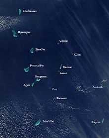
Satellite picture showing the atolls of the Lakshadweep except for Minicoy

Kiltan
Location of Kiltān Island in the Indian Ocean
| Native name: Kiltān | |
|---|---|
| Geography | |
| Location | Arabian Sea |
| Coordinates | 11°29′N 73°00′E / 11.483°N 73.000°ECoordinates: 11°29′N 73°00′E / 11.483°N 73.000°E |
| Area | 2.2 km2 (0.85 sq mi) |
| Country | |
|
India | |
| Union territory | Lakshadweep |
| Demographics | |
| Population | 4184 (as of 2009) |
Kiltan Island is a coral island belonging to the Amindivi Subgroup of islands of the Lakshadweep archipelago in India. It is located 47 km to the northeast of Amini Island and 37 km to the southeast of Chetlat Island. The reef and lagoon are located to the west of the island and the total length of the dry land area is 3.2 km.
Population
Most people from Kiltan, as in Amini and Kadmat, originally belonged to the Melacheri caste.[1] In the past, the island was part of an international trade route between the Persian Gulf and Ceylon.[2]
References
- ↑ R. H. Ellis, A short account of the Laccadive Islands and Minicoy, AES reprint 1992
- ↑ Mahatma Gandhi National Rural Employment Guarantee Act - Kiltan
External links
- Hydrographic Description (Indian Ocean Pilot)
- Lagoon sizes
- Kiltan - Geographical information
- Kiltān - Oceandots at the Wayback Machine (archived December 23, 2010)
- List of Atolls
- An ornithological expedition to the Lakshadweep archipelago
- Sources towards a history of the Laccadive Islands
- FAO - An analysis of the carrying Capacity of Lakshadweep Coral Reefs
This article is issued from Wikipedia. The text is available under the Creative Commons Attribution/Share Alike; additional terms may apply for the media files.