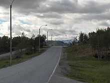
Kilpisjärvi
.jpg)

Kilpisjärvi (Northern Sami: Gilbbesjávri) is a village in the municipality of Enontekiö, Lapland, Finland. It is located in Finland's northern "arm" near the very northwesternmost point of Finland.
Although Kilpisjärvi is one of the largest villages in Enontekiö, it is still quite small. In 2000 its population was recorded as 114. Like most Lappish villages, Kilpisjärvi is built mainly around one major road, Käsivarrentie, or the "Arm Road" and Neljäntuulentie, or the "Four Winds' Road" — also known as E8. Near the Kilpisjärvi is the highest point of Finnish road network, at altitude of 528 m[citation needed].
Kilpisjärvi has its own school and a hotel, and the northernmost research station of the University of Helsinki is situated there, as well as the KAIRA research facility. The most famous tourist attractions in Kilpisjärvi are the Saana fell and the "three-country border point", a monument at the border point of Finland, Sweden and Norway, located at approximately 69°03′36″N 20°32′56″E / 69.06000°N 20.54889°E, roughly 2.5 km northwest from the end of Lake Kilpisjärvi.
In the music video for Röyksopp's Poor Leno, Leno's place of origin is listed as Kilpisjärvi.
Climate
| Climate data for Enontekiö Kilpisjärvi 1981-2010 | |||||||||||||
|---|---|---|---|---|---|---|---|---|---|---|---|---|---|
| Month | Jan | Feb | Mar | Apr | May | Jun | Jul | Aug | Sep | Oct | Nov | Dec | Year |
| Average high °C (°F) | −8.2 (17.2) |
−8.0 (17.6) |
−4.6 (23.7) |
0.5 (32.9) |
5.9 (42.6) |
12.1 (53.8) |
15.7 (60.3) |
13.7 (56.7) |
8.4 (47.1) |
1.9 (35.4) |
−4.1 (24.6) |
−7.0 (19.4) |
2.19 (35.94) |
| Daily mean °C (°F) | −12.9 (8.8) |
−12.5 (9.5) |
−9.3 (15.3) |
−3.9 (25) |
2.1 (35.8) |
7.5 (45.5) |
11.2 (52.2) |
9.6 (49.3) |
5.0 (41) |
−0.7 (30.7) |
−7.6 (18.3) |
−11.7 (10.9) |
−1.93 (28.53) |
| Average low °C (°F) | −18.0 (−0.4) |
−17.7 (0.1) |
−14.6 (5.7) |
−8.8 (16.2) |
−1.5 (29.3) |
3.6 (38.5) |
7.6 (45.7) |
6.3 (43.3) |
2.1 (35.8) |
−3.2 (26.2) |
−11.5 (11.3) |
−16.7 (1.9) |
−6.03 (21.13) |
| Precipitation mm (inches) | 50 (1.97) |
35 (1.38) |
31 (1.22) |
27 (1.06) |
27 (1.06) |
42 (1.65) |
73 (2.87) |
47 (1.85) |
36 (1.42) |
41 (1.61) |
34 (1.34) |
44 (1.73) |
487 (19.17) |
| Source: Climatological statistics for the normal period 1981–2010 [1] | |||||||||||||
References
Climatological statistics for the normal period 1981–2010 (PDF)
External links
![]() Media related to Kilpisjärvi at Wikimedia Commons
Media related to Kilpisjärvi at Wikimedia Commons
- Kilpisjärvi tourist information
- Kilpisjärvi school
- Eskelisen Lapinlinjat, offering daily bus trips to and from Kilpisjärvi
Coordinates: 69°02′57″N 20°47′40″E / 69.04917°N 20.79444°E
