Khoy
| Khoy خوی | |
|---|---|
| city | |
 | |
 Khoy | |
| Coordinates: 38°33′01″N 44°57′08″E / 38.55028°N 44.95222°ECoordinates: 38°33′01″N 44°57′08″E / 38.55028°N 44.95222°E | |
| Country |
|
| Province | West Azerbaijan |
| County | Khoy |
| Bakhsh | Central |
| Elevation[1] | 1,148 m (3,769 ft) |
| Population (2012) | |
| • Total | 200,985 |
| Time zone | IRST (UTC+3:30) |
| • Summer (DST) | IRDT (UTC+4:30) |
| Area code(s) | 0461 |
| Website | khoycity.ir |
Khoy (Persian: خوی, Azerbaijani: خوی/Xoy, Armenian: Խոյ, historical Հեր Her ; also Romanized as Khoi, Khvoy, Khowy, Khuy, and Xoy)[2][3][4] is a city in and the capital of Khoy County, West Azerbaijan Province, Iran. At the 2006 census, its population was 178,708, in 45,090 families.[5]
Khoy is located north of the province's capital and largest city Urmia, and 807 km north-west to Tehran. The region's economy is based around agriculture, particularly the production of fruit, grain, and timber. Khoy is nicknamed as the Sunflower city of Iran. As of 2006 census, the city had a population of 178,708, with an estimated 2008 population of 484,409. Azerbaijani is spoken in Khoy, while nearly all inhabitants can also converse in Persian. The main religion is Shia Islam.[6][7]
Nature
Khoy is located in the mountains, so the weather is very cold in winter and cool in summer. Spring weather in this city is very pleasant. The city is located in the vicinity of mountains such as Chelekhaneh Mount and Avrin Mount ( The highest mountain of West Azarbaijan Province ). Khoy was fortified at various times in its history, most recently by the Qajar dynasty in the Nineteenth Century. It is well known for the tomb of Shams Tabrizi, renowned Iranian poet and mystic.
After the death of Nadir Shah Afshar in 1747, Khoy broke away from central government of Iran like several other states, including Afghanistan and some of northern Caucasian Khanates, and become the Khanate of Khoy (1747–1813) which was loyal to central government only when it was powerful (like Karim Khan) and autonomous when the central role was weak . The returning of Khoy to central government of Iran was during the beginning of Qajar period. Khoy was attacked by Russia in 1827. Until 1828 Khoy had a large number of Armenian inhabitants.[citation needed] In the mid-1800s some of them immigrated to eastern Armenia in the Russian Empire. Just prior to and during World War I, Ottoman Turks killed much of the Armenian population in Khoy.[citation needed] Nowadays there is a small Armenian population living there.
In 1911 Khoy was occupied by Ottoman troops, followed in World War I by Russian troops, who withdrew in 1917. In World War II it was again occupied by Soviet troops, who remained until 1946.
Climate
Köppen-Geiger climate classification system classifies its climate as cold semi-arid (BSk).[8]
| Climate data for Khoy | |||||||||||||
|---|---|---|---|---|---|---|---|---|---|---|---|---|---|
| Month | Jan | Feb | Mar | Apr | May | Jun | Jul | Aug | Sep | Oct | Nov | Dec | Year |
| Average high °C (°F) | 2.8 (37) |
5.2 (41.4) |
11.6 (52.9) |
17.2 (63) |
23.9 (75) |
29.3 (84.7) |
32.6 (90.7) |
32.7 (90.9) |
28 (82) |
20.5 (68.9) |
13.1 (55.6) |
6.4 (43.5) |
18.61 (65.47) |
| Daily mean °C (°F) | −1.4 (29.5) |
0.6 (33.1) |
6.1 (43) |
11.2 (52.2) |
16.9 (62.4) |
21.4 (70.5) |
24.7 (76.5) |
24.5 (76.1) |
19.6 (67.3) |
13.6 (56.5) |
7.5 (45.5) |
1.9 (35.4) |
12.22 (54) |
| Average low °C (°F) | −5.6 (21.9) |
−4 (25) |
0.6 (33.1) |
5.3 (41.5) |
9.9 (49.8) |
13.5 (56.3) |
16.9 (62.4) |
16.3 (61.3) |
11.3 (52.3) |
6.7 (44.1) |
2 (36) |
−2.6 (27.3) |
5.86 (42.58) |
| Precipitation mm (inches) | 28 (1.1) |
20 (0.79) |
31 (1.22) |
47 (1.85) |
54 (2.13) |
21 (0.83) |
7 (0.28) |
5 (0.2) |
8 (0.31) |
22 (0.87) |
22 (0.87) |
19 (0.75) |
284 (11.2) |
| Source: Climate-Data.org, altitude: 1136m[8] | |||||||||||||
Sights


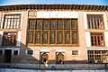
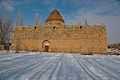
Famous places
| Wikimedia Commons has media related to Xoy. |
- Tomb of Shams Tabrizi, Shams Tabrizi Tower
- Bastam and Bolourabad Castles
- Khatoon Bridge
- Old Stone Gate
- Old Bazaar
- Motallebkhan Mosque
- Mount Avrin
- Ghotour Iron Bridge[9]
- St. Sourp Serkis Church
- Pourya-ye Vali
Famous people
- Grand Ayatollah Abul-Qassim Khoei
- Mohammad-Amin Riahi
- Abbas Zaryab Khoi
- Gholamreza Aghazadeh
- Behrouz Vossoughi
References
- ↑ "Xoy, Iran Page". Retrieved 7 July 2008.
- ↑ Khoy can be found at GEOnet Names Server, at this link, by opening the Advanced Search box, entering "-3071618" in the "Unique Feature Id" form, and clicking on "Search Database".
- ↑ van Donzel, E. J. (compiler) (1994) "Khoi" Islamic Desk Reference E.J. Brill, Leiden, p. 208 ISBN 90-04-09738-4
- ↑ "Khvoy, Iran" Falling Rain Genomics, Inc.
- ↑ "Census of the Islamic Republic of Iran, 1385 (2006)" (Excel). Islamic Republic of Iran. Archived from the original on 2011-11-11.
- ↑ "All things and news about Xoy," All things and news about Xoy .
- ↑ ""Khvoy". Archived from the original on 9 February 2013.," World Gazetteer.
- ↑ 8.0 8.1 "Climate: Khoy - Climate graph, Temperature graph, Climate table". Climate-Data.org. Retrieved 9 September 2013.
- ↑ "Ghotour Valley Bridge". American Bridge Company. Retrieved 2013-03-25.
External links
- The first portal fun of recreational and cultural city of Khoy
- Official website of Khoyee people's assembly
- Khoy government
- Khoy Municipality
- Nima Language Center
- Khoy journal
| |||||||||||||||||
