Hotan
| Hotan خوتەن 和田 | |
|---|---|
| County-level city | |
和田市 | |
 | |
 Hotan | |
| Coordinates: 37°06′N 80°01′E / 37.100°N 80.017°ECoordinates: 37°06′N 80°01′E / 37.100°N 80.017°E | |
| Country | People's Republic of China |
| Region | Xinjiang |
| Prefecture | Hotan |
| Area | |
| • Total | 85,035 km2 (32,832 sq mi) |
| Elevation | 1,382 m (4,534 ft) |
| Population | |
| • Total | 364,796 |
| • Density | 4.3/km2 (11/sq mi) |
| Time zone | China Standard (UTC+8) |
| Postal code | 839000 |
| Area code(s) | 0903 |
| Website | hts.gov.cn |
Hotan (Uyghur: خوتەن, ULY: Xoten, UYY: Hotǝn?),[1] Hetian (Chinese: 和田; pinyin: Hétián, formerly: simplified Chinese: 和阗; traditional Chinese: 和闐; pinyin: Hétián) or Khotan[2] is the seat of Hotan Prefecture in southwestern Xinjiang, People's Republic of China. It was previously known in Chinese as Yutian (simplified Chinese: 于窴; traditional Chinese: 於窴; pinyin: Yútián) and to 19th-century European explorers as Ilchi.
With a population of 114,000 (2006), Hotan is an oasis town lying in the Tarim Basin, just north of the Kunlun Mountains, which are crossed by the Sanju Pass, and the Hindu-tagh, and Ilchi passes. The town, located southeast of Yarkand and populated almost exclusively by Uyghurs, is a minor agricultural center. An important station on the southern branch of the historic Silk Road, Hotan has always depended on two strong rivers - the Karakash River and the Yurungkash River, the Black and White Jade rivers respectively - to provide the water needed to survive on the southwestern edge of the vast Taklamakan Desert. The Yurungkash still provides water and irrigation for the town and oasis.[3][4]
History

The oasis of Hotan is strategically located at the junction of the southern (and most ancient) branch of the “Silk Route” joining China and the West with one of the main routes from ancient India and Tibet to Central Asia and distant China. It provided a convenient meeting place where not only goods, but technologies, philosophies, and religions were transmitted from one culture to another.
Tocharians lived in this region over 2000 years ago. Several of the Tarim mummies were found in the region. At Sampul, to the east of the city of Hotan, there is an extensive series of cemeteries scattered over an area about a kilometre wide and 23 km (14 mi) long. The excavated sites range from about 300 BCE - 100 CE. The excavated graves have produced a number of fabrics of felt, wool, silk and cotton and even a fine bit of tapestry showing the face of Caucasoid man which was made of threads of 24 shades of colour. The tapestry had been cut up and fashioned into trousers worn by one of the deceased. An Anthropological study of 56 individuals showed a primarily Caucasoid population.[5][6] DNA testing on the mummies found in the Tarim basin showed that they were an admixture of Western Europeans and East Asian.[7]
There is a relative abundance of information on Hotan readily available for study. The main historical sources are to be found in the Chinese histories (particularly detailed during the Han[8] and early Tang dynasties) when China was interested in control of the Western Regions, the accounts of several Chinese pilgrim monks,[9] a few Buddhist histories of Hotan that have survived in Tibetan, and a large number of documents in Khotanese and other languages discovered, for the most part, early this century at various sites in the Tarim Basin and from the hidden library at the “Caves of the Thousand Buddhas” near Dunhuang.
Buddhist Khotan
The ancient Kingdom of Khotan was one of the earliest Buddhist states in the world and a cultural bridge across which Buddhist culture and learning were transmitted from India to China.[10] Its capital was located to the west of the modern city of Hotan. The inhabitants of the Kingdom of Khotan, like those of early Kashgar and Yarkand, spoke the Iranian Saka tongue. Khotan's indigenous dynasty (all of whose royal names are Indian in origin) governed a fervently Buddhist city-state boasting some 400 temples in the late 9th/early 10th century—four times the number recorded by Xuan Zang around the year 630. The Buddhist kingdom was independent but was intermittently under Chinese control during the Han and Tang Dynasty.

After the Tang Dynasty, Khotan formed an alliance with the rulers of Dunhuang. Khotan enjoyed close relations with the Buddhist centre at Dunhuang: the Khotanese royal family intermarried with Dunhuang élites, visited and patronised Dunhuang's Buddhist temple complex, and donated money to have their portraits painted on the walls of the Mogao grottos. Through the 10th century, Khotanese royal portraits were painted in association with an increasing number of deities in the caves.
In the 10th century, the Iranian Buddhist Khotan began a struggle with the Turkic Islamic Karakhanids.[11] The Karakhanid ruler, Sultan Satuq Bughra Khan, had previously converted to Islam:
Satuq's son, Musa, began to put pressure on Khotan in the mid-10th century, and sometime before 1006 Yusuf Qadir Khan of Kashgar besieged and took the city. This conquest of Buddhist Khotan by the Muslim Turks—about which there are many colourful legends—marked another watershed in the Islamicisation and Turkicisation of the Tarim Basin, and an end to local autonomy of this southern Tarim city state.—[12]

Some Khotanese Buddhist works were unearthed.[13][14][15]
Islamic Khotan
Yūsuf Qadr Khān was a brother or cousin of the Muslim ruler of Kāshgar and Balāsāghūn, Khotan lost its independence and between 1006 and 1165, became part of the Kara-Khanid Khanate. Later it fell to the Kara Kitai, after which it was ruled by the Mongols.
When Marco Polo visited Khotan in the 13th century, he noted that the people were all Muslim. He wrote that:
Khotan was "a province eight days’ journey in extent, which is subject to the Great Khan. The inhabitants all worship Mahomet. It has cities and towns in plenty, of which the most splendid, and the capital of the province, bears the same name as that of the province…It is amply stocked with the means of life. Cotton grows here in plenty. It has vineyards, estates and orchards in plenty. The people live by trade and industry; they are not at all warlike".[16][17]
The town suffered severely during the Dungan revolt against the Qing Dynasty in 1864–1875, and again a few years later when Yaqub Beg of Kashgar made himself master of East Turkestan.[18][19]
Modern Hotan
In June 2011, Hotan opened its first passenger-train service to Kashgar, which is a special economic zone.
Geography and climate
Hotan has a temperate zone, continental desert climate (Köppen BWk), with a mean annual total of only 36.5 millimetres (1.44 in) of precipitation falling on 17.3 days of the year. Due to its southerly location in Xinjiang just north of the Kunlun Mountains, during winter it is one of the warmest locations in the region, with average high temperatures remaining above freezing throughout the year. The monthly 24-hour average temperature ranges from −4.4 °C (24.1 °F) in January to 25.6 °C (78.1 °F) in July, and the annual mean is 12.54 °C (54.6 °F). The diurnal temperature variation is not large for a desert, averaging 12.3 °C (22.1 °F) annually. Although no month averages less than half of possible sunshine, the city only receives 2,587 hours of bright sunshine annually, which is on the low end for Xinjiang.
| Climate data for Hotan (1971−2000) | |||||||||||||
|---|---|---|---|---|---|---|---|---|---|---|---|---|---|
| Month | Jan | Feb | Mar | Apr | May | Jun | Jul | Aug | Sep | Oct | Nov | Dec | Year |
| Average high °C (°F) | 0.8 (33.4) |
5.9 (42.6) |
14.8 (58.6) |
23.5 (74.3) |
27.6 (81.7) |
31.0 (87.8) |
32.4 (90.3) |
31.4 (88.5) |
27.2 (81) |
20.2 (68.4) |
11.1 (52) |
2.6 (36.7) |
19.0 (66.3) |
| Average low °C (°F) | −9 (16) |
−4.4 (24.1) |
3.0 (37.4) |
10.2 (50.4) |
14.6 (58.3) |
17.7 (63.9) |
19.3 (66.7) |
18.3 (64.9) |
13.5 (56.3) |
6.0 (42.8) |
−0.9 (30.4) |
−7.1 (19.2) |
6.8 (44.2) |
| Precipitation mm (inches) | 1.6 (0.063) |
2.0 (0.079) |
1.3 (0.051) |
1.5 (0.059) |
6.6 (0.26) |
8.2 (0.323) |
5.7 (0.224) |
4.9 (0.193) |
1.8 (0.071) |
1.3 (0.051) |
.1 (0.004) |
1.5 (0.059) |
36.5 (1.437) |
| Avg. precipitation days (≥ 0.1 mm) | 2.0 | 1.7 | .7 | 1.1 | 1.9 | 2.6 | 2.9 | 1.8 | .8 | .3 | .3 | 1.2 | 17.3 |
| % humidity | 54 | 46 | 35 | 29 | 35 | 38 | 43 | 45 | 44 | 43 | 45 | 55 | 42.7 |
| Mean monthly sunshine hours | 167.8 | 163.9 | 185.8 | 208.3 | 234.5 | 253.2 | 242.5 | 231.2 | 240.0 | 260.5 | 221.1 | 178.2 | 2,587 |
| Percent possible sunshine | 55 | 54 | 50 | 53 | 54 | 58 | 54 | 55 | 65 | 75 | 72 | 60 | 58 |
| Source: China Meteorological Administration [20] | |||||||||||||
Transportation

Air
Hotan Airport serves the city.
Road
Hotan is served by China National Highway 315, which runs along the southern Tarim Basin from Ruoqiang to Kashgar, and the Trans-Taklamakan Desert Highway, which run north to Luntai.
Rail
Hotan is connected to the rest of China's rail network via the Kashgar-Hotan Railway, which opened to freight traffic in December 2010. Passenger train service on this line is limited, with only one train per day, local service 5828/5825, linking the city with Urumqui.
Buses
Regular bus services link Hotan with Kashgar. There is also an express bus to Aksu via the 430 km (270 mi) 'Hotan-Aksu Cross-Desert Highway' which was opened in 2007, travels alongside the intermittent Hotan River, and which takes about 5 or 6 hours. This same bus then goes on to Urumchi taking a total of about 21 hours from Hotan.[21]
Products


Nephrite Jade
Chinese historical sources indicate that Hotan was the main source of the nephrite jade used in ancient China. For several hundred years, until they were defeated by the Xiongnu in 176 BCE, the trade of Hotanese jade into China was controlled by the nomadic Yuezhi. The Chinese still refer to the Yurungkash as the White Jade River, alluding to the white jade recovered from its alluvial deposits. Most of the jade is now gone, with only a few kilos of good quality jade found yearly. Some is still mined in the Kunlun Mountains to the south in the summer,[22] but it is generally of poorer quality than that found in the rivers.[23][24]
Fabrics and carpets
Khotanese textiles were mentioned by Xuanzang, who visited the oasis in 644 CE. In his Biography it is stated: "It produced carpets and fine felt, and the felt-makers also spun coarse and fine silk."[25]
Ancient Chinese-Khotanese relations were so close that the oasis emerged as one of the earliest centres of silk manufacture outside China. There are good reasons to believe that the silk-producing industry flourished in Hotan as early as the 5th century.[26] According to one story, a Chinese princess given in marriage to a Khotan prince brought to the oasis the secret of silk-manufacture, "hiding silkworms in her hair as part of her dowry", probably in the first half of the 1st century CE.[27][28] It was from Khotan that the eggs of silkworms were smuggled to Persia, reaching Justinian's Constantinople in 551 AD.[29] Silk production is still a major industry employing more than a thousand workers and producing some 150 million metres of silk annually. Silk weaving by Uighur women is a thriving cottage industry, some of it produced using traditional methods.[22] Khotan Silk Factory is one of the notable silk producers in Hotan.
Atlas is a traditional Uyghur clothes which Uyghur women wears. Meaning of Atlas in Uyghur language is "tie-dyed silk fabric". It is soft, light and graceful fabric. It comes various colours, the brighter and rich colours are for small child to young ladies. The gray and dark colours are for elderly women.
The oldest piece of kilim which we have any knowledge was obtained by M. A. Stein, the archaeological explorer; a fragment from an ancient settlement near Khotan, which was buried by sand drifts about the fourth century CE. The weave is almost identical with that of modern kilims.
Khotanese pile carpets are still highly prized and form an important export.[30][31]
Gallery
-
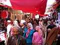
Market in Khotan
-
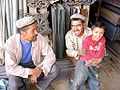
Uyghur people at Sunday market
-

Carpet weaving in Khotan
-

Silk weaving in Khotan
-

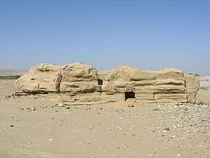
Entrance to the Hotan Cultural Museum
-

Local "mutton fat" nephrite jade displayed in Hotan Cultural Museum lobby
See also
Footnotes
- ↑ The official spelling is "Hotan" according to Zhōngguó dìmínglù 中国地名录 (Beijing, SinoMaps Press 中国地图出版社 1997); ISBN 7-5031-1718-4; p. 312.
- ↑ "Hotan - Ancient Kingdom of Jade and Silk". Central Asia Traveler. Retrieved 2012-01-16.
- ↑ Marc Aurel Stein. (1907) Ancient Khotan: Detailed Report of Archaeological Explorations in Eastern Turkestan. Oxford. Pages 123-126.
- ↑ Bonavia, Judy. The Silk Road: Xi'an to Kashgar. Revised by Christopher Baumer (2004), pp. 306-319. Odyssey Publications. ISBN 962-217-741-7.
- ↑ Mallory, J. P. and Mair, Victor H. 2000. The Tarim Mummies: Ancient China and the Mystery of the Earliest Peoples from the West, pp. 132, 155-156. Thames & Hudson. London. ISBN 0-500-05101-1.
- ↑ Bonavia, Judy. The Silk Road: Xi'an to Kashgar. Revised by Christopher Baumer (2004), p. 317. Odyssey Publications. ISBN 962-217-741-7.
- ↑ Chunxiang Li, Hongjie Li, Yinqiu Cui, Chengzhi Xie, Dawei Cai, Wenying Li, Victor H Mair, Zhi Xu, Quanchao Zhang, Idelis Abuduresule, Li Jin, Hong Zhu and Hui Zhou (2010). "Evidence that a West-East admixed population lived in the Tarim Basin as early as the early Bronze Age". BMC Biology 8 (15). doi:10.1186/1741-7007-8-15. PMC 2838831. PMID 20163704.
- ↑ Hill (2009), "The Kingdom of Yutian 于窴 (Khotan)", pp. 17-19 and nn.
- ↑ 《大唐大慈恩寺三藏法師傳》
- ↑ "Khotan - Britannica Online Encyclopedia". Britannica.com. Retrieved 2012-04-06.
- ↑ Sri Visa Sura and the Ta-Uang
- ↑ Page55 Eurasian crossroads By James A. Millward
- ↑ Mark J. Dresden, The Jatakastava or 'Praise of the Buddha's Former Births' Philadelphia, 1955
- ↑ Buddhist Khotanese Texts
- ↑ 賢愚經
- ↑ Latham, Ronald (1958). Marco Polo: the travels. p. 80.
- ↑ Wood, Frances (2002). The Silk Road: two thousand years in the heart of Asia. p. 18.
- ↑ Stein, Aurel M. (1907). "Ancient Khotan: Detailed report of archaeological explorations in Chinese Turkestan, 2 vols., p. 180. Clarendon Press. Oxford".
- ↑ Bonavia, Judy. The Silk Road: Xi'an to Kashgar. Revised by Christopher Baumer (2004), p. 309. Odyssey Publications. ISBN 962-217-741-7.
- ↑ "中国地面国际交换站气候标准值月值数据集(1971-2000年)" (in Simplified Chinese). China Meteorological Administration. Retrieved 2010-05-04.
- ↑ Harper et al (2009), p. 840.
- ↑ 22.0 22.1 Bonavia, Judy. The Silk Road: Xi'an to Kashgar. Revised by Christopher Baumer (2004), pp. 307-308. Odyssey Publications. ISBN 962-217-741-7.
- ↑ Marc Aurel Stein. (1907) Ancient Khotan: Detailed Report of Archaeological Explorations in Eastern Turkestan. Oxford. Pages 132-133.
- ↑ Laufer, Berthold. Jade: A Study in Chinese Archaeology & Religion. (1912) Reprint: Dover Publications, New York, N.Y. (1974), pp. 24, 26, 291-293, 324. ISBN 0-486-23123-2.
- ↑ A Biography of the Tripiṭaka Master of the great Ci'en Monastery of the Great Tang Dynasty. Śramaṇa Huili and Shi Yancong. Translated by Li Rongxi. Numata Center for Buddhist Translation and Research. (1995), p. 163. ISBN 1-886439-00-1.
- ↑ Whitfield, Susan. The Silk Road: Trade, Travel, War and Faith. Serindia Publications Inc., 2004. ISBN 1-932476-12-1. Page 47.
- ↑ Hill (2009), "Appendix A: Introduction of Silk Cultivation to Khotan in the 1st Century CE", pp. 466-467.
- ↑ Sarah Underhill Wisseman, Wendell S. Williams. Ancient Technologies and Archaeological Materials . Routledge, 1994. ISBN 2-88124-632-X. Page 131.
- ↑ " From Khotan, silk culture is believed to have passed by way of Kashmir to India and then westwards into central Asia and Persia". Quoted from Chambers's Encyclopaedia, Oxford University Press, 1950, article "Silk".
- ↑ Bennett, Ian. Rugs & Carpets of the World. (1978). Ferndale Edition (1981). Quarto Publishing, London, pp.182-189. ISBN 0-905746-24-4.
- ↑ "Khotan rug - Britannica Online Encyclopedia". Britannica.com. Retrieved 2012-04-06.
References
- Harper, Damian et al. (2009). Lonely Planet China: 11th Edition. Lonely Planet. ISBN 978-1-74104-866-7.
- Hill, John E. 1988. "Notes on the Dating of Khotanese History." Indo-Iranian Journal 31 (1988), pp. 179–190. See: springerlink.com Updated version of this article is available for free download (with registration) at: independent.academia.edu
- Hill, John E. 2004. The Peoples of the West from the Weilüe 魏略 by Yu Huan 魚豢: A Third Century Chinese Account Composed between 239 and 265 CE. Draft annotated English translation. depts.washington.edu
- Hill, John E. (2009) Through the Jade Gate to Rome: A Study of the Silk Routes during the Later Han Dynasty, 1st to 2nd Centuries CE. BookSurge, Charleston, South Carolina. ISBN 978-1-4392-2134-1.
- Hulsewé, A. F. P. (1979). China in Central Asia: The Early Stage 125 BC − AD 23: an annotated translation of chapters 61 and 96 of the History of the Former Han Dynasty. E. J. Brill, Leiden. ISBN 90-04-05884-2.
- Legge, James 1886. A Record of Buddhistic Kingdoms: Being an account by the Chinese Monk Fa-Hien of his travels in India and Ceylon (A.D. 399-414) in search of the Buddhist Books of Discipline. Oxford, Clarendon Press. Reprint: New York, Paragon Book Reprint Corp. 1965.
- Mallory, J. P. and Mair, Victor H. 2000. The Tarim Mummies: Ancient China and the Mystery of the Earliest Peoples from the West. Thames & Hudson. London. 2000.
- Montell, Gösta, Sven Hedin’s Archaeological Collections from Khotan: Terra-cottas from Yotkan and Dandan-Uiliq, The Bulletin of the Museum of Far Eastern Antiquities 7 (1936), pp. 145–221.
- Montell, Gösta, Sven Hedin’s Archaeological Collections from Khotan II (appendix by Helmer Smith (pp. 101–102)), The Bulletin of the Museum of Far Eastern Antiquities 10 (1938), pp. 83–113.
- Puri, B. N. Buddhism in Central Asia, Motilal Banarsidass Publishers Private Limited, Delhi, 1987. (2000 reprint).
- Stein, Aurel M. 1907. Ancient Khotan: Detailed report of archaeological explorations in Chinese Turkestan, 2 vols. Clarendon Press. Oxford. dsr.nii.ac.jp
- Stein, Aurel M. 1921. Serindia: Detailed report of explorations in Central Asia and westernmost China, 5 vols. London & Oxford. Clarendon Press. Reprint: Delhi. Motilal Banarsidass. 1980. dsr.nii.ac.jp
- Watters, Thomas 1904–1905. On Yuan Chwang’s Travels in India. London. Royal Asiatic Society. Reprint: Delhi. Mushiram Manoharlal. 1973.
- Yu, Taishan. 2004. A History of the Relationships between the Western and Eastern Han, Wei, Jin, Northern and Southern Dynasties and the Western Regions. Sino-Platonic Papers No. 131 March 2004. Dept. of East Asian Languages and Civilizations, University of Pennsylvania.
External links
| Wikimedia Commons has media related to Khotan. |
- Official government site (in Chinese)
- Silk Road Seattle - University of Washington (The Silk Road Seattle website contains many useful resources including a number of full-text historical works)
- Site devoted to the Buddhism of Khotan with a copy of Sir Aurel Stein's map of the Tarim Basin and Khotan region
- Satellite image of region which can be enlarged
- China: Taklamakan - Desert With No Ocean Underground
| |||||||||||||||||||||||||||||||||||||||||||||||||||||||||||||
| |||||||||||