Khilji, Nepal
From Wikipedia, the free encyclopedia
| Khilji/खिल्जी Nepal Khiljee | |
|---|---|
| Village development committeeगाबिस | |
|
[[file:Template:Location map khilji,Nepal|300px|Khilji, Nepal is located in Template:Location map khilji,Nepal]]<div style="position: absolute; top: Expression error: Unrecognized punctuation character "[".%; left: Expression error: Unrecognized punctuation character "[".%; height: 0; width: 0; margin: 0; padding: 0;"> [[File:Template:Location map khilji,Nepal|6x6px|Khilji/खिल्जी Nepal|link=|alt=]] Khilji/खिल्जी Nepal | |
| Coordinates: 27°59′N 83°02′E / 27.98°N 83.03°ECoordinates: 27°59′N 83°02′E / 27.98°N 83.03°E | |
| Country |
|
| Zone | Lumbini Zone |
| District | Arghakhanchi District |
| Population (1991) | |
| • Total | 2,883 |
| • Religions | Hindu |
| Time zone | Nepal Time (UTC+5:45) |
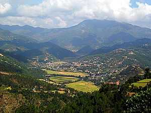
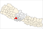
Khilji is a village in Arghakhanchi District in the Lumbini Zone of southern Nepal. At the time of the 1991 Nepal census it had a population of 2,883 and had 546 houses in the village.[1]
References
- ↑ "Nepal Census 2001". Nepal's Village Development Committees. Digital Himalaya. Retrieved 2008-08-23.
http://www.nepgis.com/VDC%20Map/detail%20vdc%20map/arghakanchi/Khilji.html
This article is issued from Wikipedia. The text is available under the Creative Commons Attribution/Share Alike; additional terms may apply for the media files.

