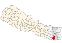
Khanar
| Khanar खनार | |
|---|---|
| Village development committee | |
 Khanar | |
| Coordinates: 26°38′N 87°17′E / 26.63°N 87.28°ECoordinates: 26°38′N 87°17′E / 26.63°N 87.28°E | |
| Country |
|
| Zone | Koshi Zone |
| District | Sunsari District |
| Population (2011) | |
| • Total |
20,323 Population male = 10,217 Population female = 10,106 |
| Time zone | Nepal Time (UTC+5:45) |
Khanar is a model VDC village development committee in Sunsari District in the Koshi Zone of south-eastern Nepal. At the time of the 2011 Nepal census it had a population of 20,323 people living in 5,130 individual households.[1][2] It lies 4 km south from Itahari Municipality and 6 km north from Duhabi vdc. Khanar is an industrial vdc with hundreds of industries. It is divided into 9 wards.
History
There are many arguments about the naming of Khanar. Some argue that the name of Khanar was named after the former King Khankar, who used to rule here long time ago. The Tharu community is the oldest community of Khanar. There is no specific date but they have been living at Khanar for a long time. They are concentrated mainly in 1, 2, 3,4,5,6, 7,8 and 9 number wards.
Geography
Located in the Eastern Region of Nepal, Khanar VDC is developing so rapidly because of high industries here.
Education & Literature
Shree Sharda Higher Secondary School is considered as the main educational foundation of Khanar, which was established in 2007 B.S. There are couple elementary and middle schools in Khanar. There are like half dozen of private schools too.
Industries
Khanar is also known for its industries. There are dozens of small and big industries. Reliance Spinning Mills Ltd,[3][4] Ami Apparels (P) Ltd [5] and several other industries are located.
References
- ↑ http://dl.dropbox.com/u/42763410/Archive%20Data/NPHC2011/index.htm
- ↑ http://census.gov.np/index.php?option=com_content&view=article&id=22&Itemid=22
- ↑ http://www.facebook.com/pages/Reliance-Spinning-Mills-Ltd-Khanar-4-Sunsari-Nepal/145496672166081
- ↑ http://www.relitex.com/profile.html
- ↑ http://www.amiapparels.com/
Template:Koshi-geo-stub
