Kexbrough
From Wikipedia, the free encyclopedia
Coordinates: 53°35′N 1°32′W / 53.58°N 1.54°W
| Kexbrough | |
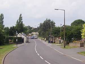
 The main high street in Kexbrough heading west towards High Hoyland |
|
 Kexbrough | |
| Metropolitan borough | Barnsley |
|---|---|
| Metropolitan county | South Yorkshire |
| Region | Yorkshire and the Humber |
| Country | England |
| Sovereign state | United Kingdom |
| Post town | BARNSLEY |
| Postcode district | S75 |
| Dialling code | 01226 |
| Police | South Yorkshire |
| Fire | South Yorkshire |
| Ambulance | Yorkshire |
| EU Parliament | Yorkshire and the Humber |
| UK Parliament | Barnsley West and Penistone |
Kexbrough is a village in the metropolitan borough of Barnsley (part of South Yorkshire, England), on the border with West Yorkshire.
Kexbrough lies directly to the west of Darton off the A637 road. It is located at approximately 53° 35' North, 1° 32' 30" West, at an elevation of around 110 metres above sea level.
Main roads
The main road that runs through the village is the A637 Huddersfield Road, although the other main roads that run through it are Churchfield Lane, which runs across the top of the M1 and Bence Lane, which also runs directly overhead on the motorway, except that this road is a housing estate.
External links
| Wikimedia Commons has media related to Kexbrough. |
- Y-Pas fish and chip shop (contains link to old photographs of Kexbrough)
This article is issued from Wikipedia. The text is available under the Creative Commons Attribution/Share Alike; additional terms may apply for the media files.