Ket River

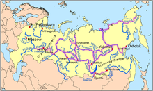
Ket River (Russian: Кеть), also known in its upper reaches as the Big Ket River (Russian: Большая Кеть) is a river in the Krasnoyarsk Krai and Tomsk Oblast in Russia, a right tributary of the Ob River. The length of the Ket River is 1,621 km. The area of its basin is 94,200 km². It freezes up in late October - early November and stays under the ice until late April - early May. Its main tributaries are the Sochur, Orlovka, Lisitsa, Little Ket, Mendel, Yelovaya, and Chachamga.
A fort was established at Ketsk in 1602 and at Makovsk on the upper Ket in 1618. In the late 19th century, the Ket-Kas Canal was built to connect the Ket with the Greater Kas River that flows into the Yenisei. This project would make the Ket a part of the waterway connecting the Ob River basin with the Yenisei. Unfortunately, being shallow, long, inconveniently located, and frozen the greater part of the year, the canal was not competitive with the Trans-Siberian Railway, and was abandoned around 1921.
This article includes content derived from the Great Soviet Encyclopedia, 1969–1978, which is partially in the public domain.
Coordinates: 58°53′56″N 81°33′30″E / 58.8989°N 81.5583°E