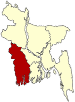
Keshabpur Upazila
| Keshabpur কেশবপুর | |
|---|---|
| Upazila | |
 Keshabpur | |
| Coordinates: 22°54.3′N 89°34′E / 22.9050°N 89.567°ECoordinates: 22°54.3′N 89°34′E / 22.9050°N 89.567°E | |
| Country |
|
| Division | Khulna Division |
| District | Jessore District |
| Area | |
| • Total | 258.53 km2 (99.82 sq mi) |
| Population (1991) | |
| • Total | 200,229 |
| • Density | 774/km2 (2,000/sq mi) |
| Time zone | BST (UTC+6) |
| Website | Official Map of Keshabpur |
Keshabpur (Bengali: কেশবপুর) is an Upazila of Jessore District in the Division of Khulna, Bangladesh.
Geography
Keshabpur is located at 22°54′15″N 89°34′00″E / 22.9042°N 89.5667°E. It has 37,513 individual households and a total area of 258.53 km². The distance from Jessore City is 32 km.
Demographics
As of the 1991 Bangladesh census, Keshabpur has a population of 200,229. Males constitute 51.16% of the population, and females 48.84%. This Upazila's eighteen up population is 103,794. Keshabpur has an average literacy rate of 55.5% (in those aged seven and above), while the national average is 68.4%. The Keshabpur Pilot School & College is the pride of Keshabpur Upazilla, Keshabpur College is one of the best colleges of the Jessore district and Keshabpur Bahrul Ulum Kamil Madrasha is the best Islamic Biddapith of south Bengal.[citation needed]
Administrative
Keshabpur Upazila (jessore district) has an area of 258.53 km2 and is bounded by Manipampur upazila to the north, Tala and Dumuria upazilas to the south, Dumuria upazila to the east, and Kalaroa upazila to the west. The main rivers are Harthar and Chengral; Beels 20.
Keshabpur (Town) consists of seven mouzas. The area of the town is 18.46 km². The town has a population of 20,697; male 50.88%, female 49.12%. Population density is 1121 per km2. The literacy rate within the town is 32.9%.
Keshabpur thana was turned into an upazila in 1983. It consists of 9 union parishads, 142 mouzas and 143 villages.
Heritage
Archaeological heritage and relics include remnants of the Bharatvhainabazar Rajbari ( Vhani Family-দেউলটি গুপ্ত যুগের খ্রিষ্টীয় ২য় শতকে নির্মিত হয়েছে বলে অনুমান করা হয় ), the residence of Nawab Mir Jumla (17th century), the residence of poet Madhusudan Dutt at Sagardari, and remnants of an ancient fort at village Bidhyanandikathi.
1971
Marks of the War of Liberation Memorial 1.
Population 200,229; male 51.16%, female 48.84%; Muslim 80.14%, Hindu 19.5% and others 0.36%.
Religious institutions Mosque 320, temple 81, most noted of which is Nawab Bari Mosque at Sheikhpara.
Pir Mohammad Vhani was an organizer of 1971
Education
Literacy and educational institutions Average literacy 31.7%; male 33.5% and female 29.8%. Educational institutions: college 5, high school 32, madrasa 97, government primary school 70, non-government primary school 85. Noted educational institutions: Keshabpur Degree College (1967), Keshabpur Pilot Collegiate School, Keshabpur Girls' School, Panjia High School, Biddyanandkati Rasbihari Institution.
Cultural org
Cultural organisations Press club 1, theatre group 3, cinema hall 2, public library 1, literary society 1, women's organisation 3, playground 10, Madhusudan Academy 1, Madhusudan Museum 1.
Land
Main occupations Agriculture 47.84%, agricultural labourer 26.52%, wage labourer 2.27%, commerce 9.43%, service 3.45%, industry 1.54%, transport 2.62% and others 6.33%.
Land use Total cultivable land 20404.28 hectares; fallow land 297.86 hectares; single crop 28%, double crop 61% and treble crop 21%. Cultivable land under irrigation 63%.
Land control among the peasants: 12% are landless, 64% small, 22% intermediate and 2% rich; cultivable land per head 0.12 hectare.
Value of Land Market value of land of the first grade is approximately Tk 6000 per 0.01 hectare.
Produce
Main crops: Paddy, wheat, jute, potato, betel leaf, sugarcane, oil seed, chilli, turmeric, vegetables.
Extinct or nearly extinct crops: Local varieties of paddy, arahar, khesari.
Main fruits: Mango, jackfruit, black berry, betel nut and coconut.
Fisheries, poultries: Poultry 382, hatchery 1 and fishery 647.
Communication
Communication facilities - Roads: pucca 41 km, semi pucca 5 km and mud road 374 km; waterways: 9-nautical-mile (17 km).
Traditional transport: Palanquin and bullock cart. These means of transport are either extinct or nearly extinct.
Cottage industries: Weaving 328, goldsmith 50, blacksmith 72, potteries 203, wood work 83, tailoring 125 and welding 12.
Haat Bazar
Hats, bazars and fairs: Total number of hats and bazars are 23, fair 5, most noted of which are Bharat Bhaina, Panjia, Katakhali, Mangalkot, Chigra Bazar, Saraskathi, Trimhani Kobadak Snan Mela, Sagardari Madhu Mela.
Main exports: Paddy, jute, jackfruit, wheat and date molasses.
NGOs
NGO activities: Operationally important NGOs are brac, asa, grameen bank, caritas, Samadhan, Samaj Kalyan Sangstha, Dhaka Ahsania Mission, Sheba Samaj Kallyan Sangstha, UNNAYAN, Gono Uddok Forum, Banful, MSWO(Michel Social Welfare Organization)
Places to visit
Sagardari is a village in the Keshabpur Upazila, built on the bank of the Kopotakho River, where the poet Michael Madhusudan Dutt was born on the 25 January 1824. Tourists from all over the world visit "Modhu Palli" and "Modhu Mela", a fair in memory of Modhusudan's Birthday, is held every year.
References
I like Your Keshabpur Upazila for different side of view and historical place. Thanks a lot to WIKIPEDIA as well as Khulna Division for presenting this website from M.Hasan.
