Kelso Mountains
From Wikipedia, the free encyclopedia
| Kelso Mountains | |
|---|---|
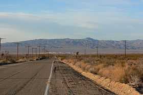
 Kelso Mountains seen from Kelbaker Road south of Kelso | |
| Highest point | |
| Elevation | 1,226 m (4,022 ft) |
| Geography | |
<div style="padding:2px 2px 5px 2px;> | |
| Country | United States |
| State | California |
| District | San Bernardino County |
| Range coordinates | 35°05′21″N 115°44′23″W / 35.0892°N 115.7397°WCoordinates: 35°05′21″N 115°44′23″W / 35.0892°N 115.7397°W |
| Topo map | USGS Kelso |
The Kelso Mountains are located just north of the small community of Kelso and the Kelso Dunes, in the Mojave National Preserve in southeastern California. The town of Baker, near Interstate 15, lies approximately 18 miles (29 km) to the northwest of the mountain range. Kelso Peak, at 4,764 feet (1,452 m), is the principal peak of the range. Like most of the Mojave Desert, the range is characterized by little rainfall, and usually receives less than 5–6 inches (125–150 mm) of precipitation in a normal year.
References
- ↑ "Kelso Mountains". Geographic Names Information System, U.S. Geological Survey. Retrieved 2009-05-04.
- Allan, Stuart (2005). California Road and Recreation Atlas. Benchmark Maps. p. 87. ISBN 0-929591-80-1.
This article is issued from Wikipedia. The text is available under the Creative Commons Attribution/Share Alike; additional terms may apply for the media files.