Kawfakha
| Kawfakha | ||
| ||
 Kawfakha |
||
| Arabic | كوفخة | |
| Also Spelled | Kaufakha | |
| Subdistrict | Gaza | |
| Coordinates | 31°28′41.66″N 34°39′41.82″E / 31.4782389°N 34.6616167°ECoordinates: 31°28′41.66″N 34°39′41.82″E / 31.4782389°N 34.6616167°E | |
| Population | 500 (1945) | |
| Area | 8569 dunams | |
| Date of depopulation | May 25, 1948[1] | |
| Cause(s) of depopulation | Military assault by Yishuv forces | |
| Current localities | Nir Akiva | |
Kawfakha' (Arabic: كوفخة) was a Palestinian village located 18 kilometers (11 mi) east of Gaza that was depopulated during the 1948 Arab-Israeli war.
Location
The village stood on a stretch of sandy, rolling land in the northern Negev. A network of secondary roads linked it to the highways between Gaza and Julis, which ran parallel to the coastal highway.[2]
History
The village contained ruins of Khirbat al-Kawfakha which included remnants of cisterns, marble columns, a Corinthian capital, mosaic walkways, and pottery.[3]
Kawfakwa was founded in the late nineteenth century by Gaza city residents who came to cultivate the surrounding land. In its center was a mosque that was well known in the region, built in the reign of the Ottoman sultan Abd al-Hamid II (1876–1909).[2]
Kawfakha had an elementary school and some small shops. The villagers, who all were Muslim, obtained water for domestic use from two wells inside the village. The land on the northern side of the village was planted with fruit trees, such as apricots, olives, almonds, grapes and figs. On the other sides of the village grain was grown. In 1944/45 a total of 97 dunums was irrigated or used for orchards, and 7,768 dunums (of public land) were allotted to cereals.[4][5]
1948 and after
During the 1948 Arab-Israeli War, the villagers of Kawfakha repeatedly asked to surrender, accept Jewish rule and be allowed to stay, all to no avail.[6] Kawfakha, together with al-Muharraqa, was raided by the Palmach's Negev Brigade on May 27–28, and the inhabitants of both villages were expelled or driven out.[7] On May 30, a New York Times correspondent reported that the two villages had been captured.[8]
The Israeli settlement of Nir Akiva was established in 1953 on village lands, southwest of the village site.[8]
According to Khalidi, by 1992 the village remaining structures on the village land were:
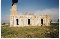
"Only the mosque remains, and it is used as a storehouse for animal fodder and as a horse stable. It is a stone structure with arched entrances and windows on all sides; its roof is topped by three shallow domes. The site, which contains piles of rubble and is overgrown with cactuses and other desert plants, has been fenced in and serves as a pasture. There is a citrus grove west of it, and grain is grown by Israeli farmers on part of the surrounding land."[8]
The village mosque was inspected in 1994, and found to be built of ashlar stones (approximately 0.2m x 0.4 m) with the corners emphasised by a slight offset. At the north-west corner there was a thick square minaret 10–15 meters high with chamfered corners. There are three doorways on the north side, two of which lead into the prayer hall, whilst the east door leads into a separate room. At the time of the inspection, the mosque was used as a storehouse for a nearby farm ("Avi´s Ranch").[9]
See also
- List of Arab towns and villages depopulated during the 1948 Arab-Israeli War
References
- ↑ Morris, 2004, p. xx village #368. Also gives the cause of depopulation.
- ↑ 2.0 2.1 Khalidi, 1992, p. 119
- ↑ Conder and Kitchener, 1883, SWP III , p. 283. Quoted in Khalidi, 1992, p.120
- ↑ Khalidi, 1992, p.119-120
- ↑ Hadawi, 1970, p. 87
- ↑ Morris, 2004, p. 258. Citing from Palmah and Israel State Archives.
- ↑ Morris, 2004, p, 258
- ↑ 8.0 8.1 8.2 Khalidi, 1992, p. 120
- ↑ Petersen, 2002, p. 195-6.
Bibliography
| Wikimedia Commons has media related to Kawfakha. |
- Barron, J. B., ed. (1923). Palestine: Report and General Abstracts of the Census of 1922. Government of Palestine.
- Conder, Claude Reignier; Kitchener, H. H. (1883). The Survey of Western Palestine: Memoirs of the Topography, Orography, Hydrography, and Archaeology 3. London: Committee of the Palestine Exploration Fund.
- Dauphin, Claudine (1998). La Palestine byzantine, Peuplement et Populations, Vol. III : Catalogue. BAR International Series 726. Oxford: Archeopress. (p.955)
- Hadawi, Sami (1970). Village Statistics of 1945: A Classification of Land and Area ownership in Palestine. Palestine Liberation Organization Research Center. (Population; p. 46, cultivated land; p.87, non-cultivated land; p. 137)
- Khalidi, Walid (1992). All that Remains. Washington DC: Institute for Palestine Studies. ISBN 0-88728-224-5.
- Mills, E., ed. (1932). Census of Palestine 1931. Population of Villages, Towns and Administrative Areas. Jerusalem: Government of Palestine.
- Morris, Benny (2004). The Birth of the Palestinian Refugee Problem Revisited. Cambridge University Press. ISBN 0-521-00967-7.
- Palmer, E. H. (1881). The Survey of Western Palestine: Arabic and English Name Lists Collected During the Survey by Lieutenants Conder and Kitchener, R. E. Transliterated and Explained by E.H. Palmer. Committee of the Palestine Exploration Fund.
- Petersen, Andrew (2001): A Gazetteer of Buildings in Muslim Palestine: Volume I (British Academy Monographs in Archaeology)
