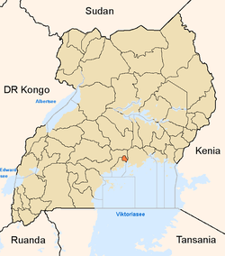
Kawempe
| Kawempe | |
|---|---|
 Kawempe | |
| Coordinates: 00°22′45″N 32°33′27″E / 0.37917°N 32.55750°E | |
| Country |
|
| Region | Central Uganda |
| District | Kampala Capital City Authority |
| Division | Kawempe Division |
| Time zone | EAT (UTC+3) |
Kawempe is an area in the city of Kampala, Uganda's capital. It is also the location of the headquarters of Kawempe Division, one of the five (5) administrative divisions of Kampala. The five divisions are:
Location
Kawempe is located on the northwestern edge of Kampala. It is bordered by Nabweru to the north, Kisaasi to the east, Bwaise to the south, Kazo to the southwest and Nansana in Wakiso District to the west. The coordinates of Kawempe are: 00°22′45″N, 32°33′27″E (Latitude:0.3792; Longitude:32.5574). The road distance between Kampala's central business district and Kawempe is approximately 8.5 kilometres (5.3 mi).[1]
Overview
Kawempe lies on the main highway between Kampala and Masindi. It began as a trading center in the 1950s but has mushroomed into a busy, albeit disorganized, metropolitan area with businesses, small industries, retail shops and a thriving farmers market. Many of the surrounding villages have been turned into low income housing. Arguably, Kawempe has the lowest income per capita of all the city's five divisions, it is also the langest division in kampala
Landmarks
Kawempe boasts of the following landmarks:
- Headquarters of Kawempe Division
- Bugisu Industries Limited - Manufactures packaging materials
- Harris International Stores
- Kawempe Muslim High School - One of the best in Uganda
- A branch of Bank of Baroda
- A branch of Barclays Bank
- A branch of Equity Bank
- A branch of Orient Bank - A member of the Bank PHB Group
- A branch of Stanbic Bank
- A branch of Opportunity Uganda Limited - A Tier II Financial Institution.[2]
- A branch of Pride Microfinance Limited - A Tier III Financial Institution
- Kawempe Central Market
- Kawempe General Hospital - A public hospital under the administration of the Uganda Ministry of Health
External links
See also
References
Coordinates: 00°22′45″N 32°33′27″E / 0.37917°N 32.55750°E
