Katzenbuckel
From Wikipedia, the free encyclopedia
| Katzenbuckel | |
|---|---|
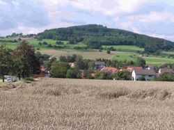 View to the Katzenbuckel | |
| Elevation | 626 m (2,054 ft) |
| Translation | Cat's arched back (German) |
| Location | |
 Katzenbuckel | |
| Location | Baden-Württemberg, Germany |
| Range | Odenwald |
| Coordinates | 49°28′15″N 9°02′28″E / 49.47083°N 9.04111°ECoordinates: 49°28′15″N 9°02′28″E / 49.47083°N 9.04111°E |
The Katzenbuckel (626 metres) is an extinct volcano and the highest elevation of the Odenwald. The mountain is located eastwards of Eberbach, near the village of Waldbrunn.
This article is issued from Wikipedia. The text is available under the Creative Commons Attribution/Share Alike; additional terms may apply for the media files.