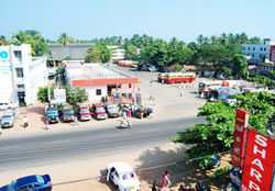
Karunagappalli
| Karunagappally കരുനാഗപ്പള്ളി Karunagappally | |
|---|---|
| town | |
 | |
 Karunagappally | |
| Coordinates: 9°3′16″N 76°32′7″E / 9.05444°N 76.53528°ECoordinates: 9°3′16″N 76°32′7″E / 9.05444°N 76.53528°E | |
| Country |
|
| State | Kerala |
| District | Kollam |
| Government | |
| • Body | Karunagappally Municipality |
| • Chairman | M. Ansar |
| • Vice Chairman | Lekshmi Mohan |
| Area | |
| • Total | 66.34 km2 (25.61 sq mi) |
| Elevation | 14 m (46 ft) |
| Population (2011) | |
| • Total | 410,514 |
| • Density | 856/km2 (2,220/sq mi) |
| Languages | |
| • Official | Malayalam, English |
| Time zone | IST (UTC+5:30) |
| PIN | 690518 |
| Telephone code | +91 (0)4762 |
| Vehicle registration | KL-23 |
| Nearest city | Kollam (27 km) |
| Sex ratio | 999 ♂/♀ |
| Literacy | 94.26% |
| Planning agency | Karunagappally Development Authority |
| Civic agency | Karunagappally Municipality |
| Climate | Am/Aw (Köppen) |
| Avg. annual temperature | 27.2 °C (81.0 °F) |
| Avg. summer temperature | 35 °C (95 °F) |
| Avg. winter temperature | 24.4 °C (75.9 °F) |
Karunagappalli is a municipality in Kollam district, Kerala, India. Karunagappally is situated in 27 km north from Kollam.
Karunagappally municipality consist of Alappad, Ochira, Adinad, Karunagappally, Thazhava, Pavumba, Thodiyoor, Kallalibhagom, Thevalakkara, Chavara, Neendakara, Clappana, Kulasekharapuram, Thekkumbhagam, Ayanivelikulangara, Panmana and Vadakumthala. The Municipality is bound on the north by Kayamkulam, east by Kunnathur taluk, south by Kollam and on the west by the Arabian Sea.
Legend
There however is another claim that 'Palli' is a term with Buddhist roots and that Karungappally was a Buddhist settlement in early times and that the name has its origin in a famous Buddhist education centre in the area. It is also argued that nearby Karthigappally and Mynagappally too were Buddhist centres of learning. Remnants suggesting a Buddhist past of the place have been found in many locations here. [citation needed] . Amritapuri also situated in karunagappally.
Demographics
The 2001 India census puts the population of Karungappally Taluk at 610,514 of which 299494 are males and 311,020 females. As with the rest of the state the population of the Taluk is a heterogenous mix of Hindus, Muslims and Christians. The high literacy of Kerala is reflected in Karunagappally as well with 89.50% of the population classified as literate as against the national average of 60.50%.
Economy
Karungappally used to be an agrarian economy until the late 19th century with coconut, banana, tapioca and paddy as the main crops grown. With rapid urbanization and the consequent pressure on land the reliance on agriculture has dwindled. Several cottage and small industries have now come up in the area in brick making, engineering and electronics. Proximity to Kollam (27 km) and the excellent road and rail infrastructure have helped in this transition. [citation needed]
The area also receives substantial foreign remittances from the large number of people from here working in the Gulf countries. Fishing forms the major source of livelihood for the coast dwellers [citation needed]
Environment
Karunagappally is known for high background radiation from thorium-containing monazite sand. In some coastal panchayats, median outdoor radiation levels are more than 4 mGy/yr and, in certain locations on the coast, it is as high as 70 mGy/yr.[1]
Transport
Main transport is provided by State owned Kerala State Road Transport Corporation (KSRTC) and private transport bus operators. Karunagappally Bus Station is on National Highway 47. Buses ply from Karunagappally to Thiruvananthapuram, Alappuzha, Kumily, Kollam, Chavara and Sasthamkotta. Local services are also available to various places in the district. The station operates super fast, fast passenger and ordinary buses. KSRTC Bus stand is situated in the heart of the town. Road transport is also supported by private taxis and autorickshaws also called autos.
Karunagappally Railway Station, situated in Edakkulangara falls on the Thiruvananthapuram-Ernakulam railway line.Mumbai(lokamanyathilak)-Thiruvananthapuram-Netravathy express, Kanyakumari-Bangalore Island Express, Parasuram Express, Venad Express, Malabar Express, Amritha Express and Thiruvananthapuram-Ernakulam Express are the main train connections. Station Code: KPY.
Trivandrum International Airport is the nearest airport.

Politics
Karunagapally assembly constituency is part of Alappuzha Lok Sabha constituency.[2]
Industries
The major employers in the public sector are Indian Rare Earths Limited (IRE), Kerala Minerals and Metals Limited (KMML) at Shankaramangalam, KERAFED Puthiyakavu, House Boat Manufacturing Alumkadavu & Kozhikode.The state owned Kerala Feeds Ltd.located at Kallelibhagom is also a major industry. Cashew nut industry plays a vital role. Coconut, Paddy, tapioca, Banana etc. are the other main agricultural crops. Prominent small scale and cottage industries are based on bricks, well rings making, engineering and electronics items handicrafts etc.
References
- ↑ Nair RR, Rajan B, Akiba S, Jayalekshmi P, Nair MK, Gangadharan P, Koga T, Morishima H, Nakamura S, Sugahara T. (January 2009). "Background radiation and cancer incidence in Kerala, India-Karanagappally cohort study.". Health Physics.
- ↑ "Assembly Constituencies - Corresponding Districts and Parliamentary Constituencies". Kerala. Election Commission of India. Retrieved 2008-10-20.
External links
| Wikimedia Commons has media related to Karunagappally. |
 |
Alappuzha district | Pathanamthitta district | | |
| Arabian Sea | |
Tirunelveli district, Tamil Nadu | ||
| ||||
| | ||||
| Thiruvananthapuram district |
| ||||||||||||||||||||||