Karori
| Karori | |
|---|---|
| Basic information | |
| Local authority | Wellington City |
| Date established | 1840 |
| Population | 14,013[1] (2006) |
| Facilities | |
| Surrounds | |
| Northeast | Wilton |
| East | Northland |
| Southeast | Highbury, Taitville |
| Northwest | Makara |
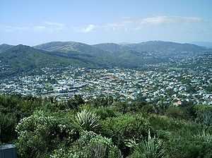
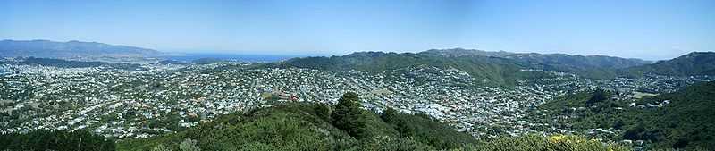
Karori is a suburb located at the western edge of the urban area of Wellington, New Zealand, some 4 km from the city centre.
Karori is significantly larger than most other Wellington suburbs, having a population of over 14,000 at the time of the 2006 census.[1]
History

The first settlers came to Karori in 1840, having bought the land from the New Zealand Company. Karori was originally established as a separate settlement, not an extension of Wellington proper. As such, it had a separate political existence, and was officially established as a borough in 1891. Both Wellington and Karori expanded towards each other, the two urban areas becoming gradually connected (aided by the construction of the Karori tunnel in 1901), and the Borough of Karori was amalgamated into the City of Wellington in 1920.[2]
Features of Karori
Karori is home to Zealandia (formerly called the Karori Wildlife Sanctuary), an enclosed restoration project focusing on the flora and fauna that inhabited the valley before human settlement. Other conservation activities in Karori are undertaken by FROKS - Friends and Residents of Karori Stream.[3] a volunteer group restoring the banks of Karori Stream. Several other parks and reserves can be found on the hills surrounding Karori, as well as the headwaters of the Kaiwharawhara Stream.[4] Wrights Hill Fortress, a network of tunnels and gun emplacements overlooking the valley, is an important historical site.
The centre of Karori contains a shopping mall, new public library and café, and other amenities. Karori is also home to a campus of Victoria University of Wellington, formerly the Wellington College of Education, and Helen Lowry Hall of Residence. There are three primary schools in Karori. St Teresa's School, which is an integrated school, serves the Catholic population of the suburb. Karori Normal School in Donald Street serves the eastern and central part of the suburb. Karori West Normal School in Allington Road serves the western end of the suburb. Karori Normal and St Teresa's School are ranked as Decile 10 schools by the New Zealand Ministry of Education while Karori West is Decile 8.
Karori Normal School, founded in 1857, is one of the largest primary schools in New Zealand with 850 pupils attending. It has an artificial turf, two playgrounds, 34 classrooms in approximately four buildings, a concrete field, and a grass field. Students from Year 1-8 attend. The author Katherine Mansfield attended the school from 1895–98 and there is a memorial to her at the school on a concrete field called the Katherine Mansfield field, located in front of a tree she wrote about in one of her stories.
Samuel Marsden Collegiate School, a private Anglican girls' school, is in Karori Road at Marsden Village. It offers classes from new entrants to Year 13.
The full length of Karori Road is served by the Karori Park trolley bus route, which replaced the former tram service in 1954. For many years vehicles ran as route 12 to Courtenay Place, but are now designated as route 3 and through-routed to and from Lyall Bay via the city. The weekday 10-minute service is the most-frequent of all Wellington routes.
Karori Cemetery is the second largest cemetery in New Zealand. Opened in 1891, it replaced the cemetery at Bolton Street as the main burial ground for the inhabitants of Wellington. It covers 100 acres / 40 hectares. The Small Chapel contains excellent stained glass windows designed by Wilhelmina Geddes. The cemetery contains the war graves of 267 Commonwealth service personnel of World War I and 123 of World War II, in separate plots for each war,[5] the plots being linked by the Wellington Provincial Memorial (in the form of a marble archway) which commemorates 65 World War I and 20 World War II military personnel from the Wellington Military District who died abroad and have no known grave (most were buried at sea).[6] Karori Cemetery "closed" in 1965 for the establishment of new burial plots but interments in established graves continues.
Futuna Chapel, located in Karori, is one of New Zealand's most significant pieces of 20th century architecture, having been recognised by the New Zealand Institute of Architects.
References
- ↑ 1.0 1.1 The population is the aggregate for the Census areas of Karori North (Quickstats about Karori North), Karori Park (Quickstats about Karori Park, Karori East (Quickstats about Karori East) and Karori South (Quickstats about Karori South)
- ↑ "Karori". Wellington Local History. Wellington City Libraries. Retrieved 2010-11-11.
- ↑
- ↑ Greater Wellington - Kaiwharawhara catchment
- ↑ CWGC Cemetery Report.
- ↑ CWGC Cemetery Report.
Coordinates: 41°17′05″S 174°44′12″E / 41.284855°S 174.736795°E