Kangping County
From Wikipedia, the free encyclopedia
| Kangping County 康平县 | |
|---|---|
| County | |
 | |
 Kangping | |
| Coordinates: 42°45′N 123°21′E / 42.750°N 123.350°ECoordinates: 42°45′N 123°21′E / 42.750°N 123.350°E | |
| Country | People's Republic of China |
| Province | Liaoning |
| Sub-provincial city | Shenyang |
| County seat | Kangping Town (康平镇) |
| Area | |
| • Total | 2,173 km2 (839 sq mi) |
| Elevation | 111 m (364 ft) |
| Population (2010) | |
| • Total | 353,061 |
| • Density | 160/km2 (420/sq mi) |
| Time zone | China Standard (UTC+8) |
| Postal code | 110500 |
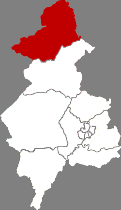
Kangping (Chinese: 康平; pinyin: Kāngpíng) is a county in northern Liaoning province, People's Republic of China, bordering Inner Mongolia to the northwest, and is under the administration of the provincial capital, Shenyang, the downtown of which is 104 km (65 mi) to the south. As of 2010, it has a population of 353,061 residing in an area of 2,173 km2 (839 sq mi). It lies just off of G25 Changchun–Shenzhen Expressway.
Administrative divisions
The county includes 7 towns, 4 townships, and 4 ethnic townships.[1]
|
Towns:
|
Townships:
|
References
- ↑ "2011年统计用区划代码和城乡划分代码:康平县" (in Simplified Chinese). National Bureau of Statistics of the People's Republic of China. Retrieved 2012-07-17.
External links
| ||||||||||||||||||||||||||||||||||||||||||||||||||||||
This article is issued from Wikipedia. The text is available under the Creative Commons Attribution/Share Alike; additional terms may apply for the media files.