Kandalama Reservoir
From Wikipedia, the free encyclopedia
| Kandalama Reservoir | |
|---|---|
 | |
| Country | Sri Lanka |
| Location | Kandalama |
| Coordinates | 07°52′38″N 80°42′00″E / 7.87722°N 80.70000°ECoordinates: 07°52′38″N 80°42′00″E / 7.87722°N 80.70000°E |
| Purpose | B |
| Status | Operational |
| Owner(s) | Mahaweli Authority |
| Dam and spillways | |
| Type of dam | Embankment dam |
| Length | 1,600 m (5,200 ft) |
| Height | 21 m (69 ft) |
| Reservoir | |
| Total capacity | 33,300,000 m3 (1.18×10⁹ cu ft) |
| Catchment area | 102 km2 (39.4 sq mi) |
| Max. length | 4.8 km (3.0 mi) |
| Max. width | 2.3 km (1.4 mi) |
The Kandalama Reservoir (also erroneously known as the Kandalama Lake) is a reservoir in Kandalama, Sri Lanka. The reservoir is created by the 21 m (69 ft) high and 1,600 m (5,200 ft) wide Kandalama Dam. Water from the dam is used for irrigation purposes in the region, extending up to Kekirawa.[1]
The reservoir measures 4.8 km (3.0 mi) and 2.3 km (1.4 mi) at its longest length and width respectively, with a catchment area of 102 km2 (39.4 sq mi) and a volume of 33,300,000 m3 (1.18×10⁹ cu ft). Due to its scenic surroundings, and year-round water availability, the reservoir is a very popular tourist destination in Sri Lanka.[1][2]

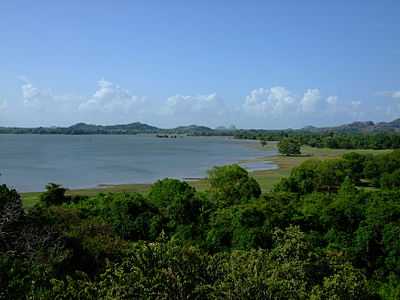
Northern region of the Kandalama Reservoir, as seen from Heritance Kandalama in June 2008.
See also
| Wikimedia Commons has media related to Kandalama Reservoir. |
Refereneces
- ↑ 1.0 1.1 "Kandalama Reservoir". DamSafety.lk. Retrieved 1 January 2014.
- ↑ Gamini Warushamana (16 September 2012). "Drought helps expedite renovation work on Kalawewa tank". Sunday Observer. Retrieved 18 January 2014.
External links
- "Man drowns in Kandalama reservoir". Daily News. 8 August 2013. Retrieved 18 January 2014.
| |||||||||||||||||||||||||||||||||||
This article is issued from Wikipedia. The text is available under the Creative Commons Attribution/Share Alike; additional terms may apply for the media files.