Kafue River
| Kafue | |
| River | |
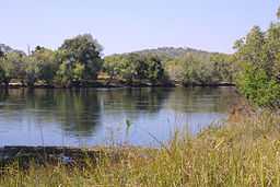 Kafue River, Chamufumbu, near Lubungu Pontoon, Zambia | |
| Country | Zambia |
|---|---|
| Source | |
| - location | near Munyanshi Swamp (Zambian border with the Democratic Repuplic of Congo, Zambia |
| - elevation | 1,350 m (4,429 ft) |
| - coordinates | 13°S 27°E / 13°S 27°E |
| Mouth | Zambesi |
| - location | near Chirundu, Zambia |
| - coordinates | 16°S 28°E / 16°S 28°E |
| Length | 960 km (597 mi) |
| Basin | 155,000 km2 (59,846 sq mi) |
| Discharge | |
| - average | 320 m3/s (11,301 cu ft/s) |
The Kafue River is a major tributary of the Zambezi, and of Zambia's principal rivers, it is the most central and the most urban, and the longest and largest lying wholly within Zambia.[1]
Dimensions
The Encyclopædia Britannica reports the course of the Kafue River as 960 km long,[2] however, having to follow intricate meanders, a boat trip would be about 2000 km.[3]
The river drains a basin of 155,000 km² and has a mean flow rate of 320 m³/s through its lower half, with high seasonal variations. It discharges 10 km³ per year into the Zambezi River.[4]
Course of the river
Source
The Kafue River rises at an elevation of 1350 m on the relatively flat plateau just south the border of Zambia and the Democratic Republic of the Congo, 120 km north-west of Chingola in the Copperbelt Province. The area is Miombo woodland on the Congo-Zambezi watershed, with many branching dambos lying 10 to 20 m lower than the highest ground, producing a very gently undulating topography. The river starts as a trickle from the marshy dambos (the Munyanshi Swamp is a tributary) and with little slope to speed up river flow, it meanders south-eastwards sluggishly and within 50 km has the character of a mature river. The area receives about 1200 mm rain in the rainy season, and the river's channel soon reaches 100 m wide with a floodplain of fluvial dambos 1–2 km wide.[5]
Through the Copperbelt
Before the river reaches the Copperbelt towns, however, it loses its wide floodplain, the channel narrows to 30–40 m and it meanders less, in a shallow valley only 40 m or so lower than the surrounding plateau. It flows close to the Copperbelt towns of Chililabombwe, Chingola and Mufulira, and through the outskirts of Nchanga and Kitwe.[6] The popular picnic spot the Hippo Pool north of Chingola is protected as a national monument.
In the Copperbelt, water is taken from the river to irrigate small farms and market gardens. At Kitwe it changes course to the south-west and flows through forests and areas of flat rock over which it floods in the wet season, keeping to a channel about 50 m wide in the dry season.[5]
The Lukanga Swamp
It then again develops intricate meanders and a maze of channels in a swampy floodplain, with oxbow lakes and lagoons. It flows 20 km west of the permanent part of the Lukanga Swamp which fills a circular depression, and which drains through a channel into the Kafue. The area between the swamp and river is flood plain and when that and surrounding areas are inundated in the rainy season, the combined wetland exceeds 6000 km².[5] This is the first of the three main wildlife areas of the river, and the least surveyed and protected.
Through Kafue National Park
The character of the river changes again, as it forms a less meandering dry-season channel with sandy banks and islands. Continuing south-west it enters the Kafue National Park, second largest national park in Africa, where it receives its two largest tributaries, the Lunga and Lufupa rivers, also from the north.[6] The Kafue skirts the south-east edge of the Busanga Plain, one of Africa’s premier wildlife areas, known for large herds of cape buffalo, zebra and antelope. In the rainy season the Lufupa floods the plain.[1]
Itezhi-Tezhi Gap
Like the upper Zambezi, Okavango and Cuando rivers, the Kafue used to flow south all the way to Lake Makgadikgadi and the Limpopo River, but the land in that area was uplifted. A rift valley formed running due east of where the Kafue National Park is now, and the Kafue river, eroding a channel called the Itezhi-Tezhi Gap through a ridge of 100 m high hills, became diverted eastwards. The Itezhi-Tezhi Dam was built in 1977 at the gap and now forms a reservoir 50 km long and up to 10 km wide.[1]
Kafue Flats
In its journey east, the river flows sluggishly across a flat plain called the Kafue Flats (formerly Butwa after the Twa people) and for the third time develops intricate meanders in a maze of swampy channels and lagoons. This time however it also has an immense shallow flood plain which no roads or railways cross, 240 km long and about 50 km wide,[5] flooded to a depth of less than a metre in the rainy season (deeper in some lagoons and permanently swampy areas), and drying out to a clayey black soil in the dry season. The Kafue Flats are the third major wildlife area of the river. Tens of thousands of Kafue Lechwe live on the Kafue Flats and are adapted to wading the flood. The area also has one of the greatest variety and concentrations of birds in the world. The Lochinvar and Blue Lagoon National Parks have been established on the flats.[1]
Around Mazabuka and as the river gets closer to the town of Kafue, sugar plantations and other large agricultural estates have been established on the fertile black soil and use water from the river in the dry season.[1]
Kafue Gorge and Dam
The Kafue Flats end at Kafue town and from there, as the rift valley gets deeper, the river drops 550 m over 60 km through the Kafue Gorge.[5] A second dam, the Kafue Gorge Dam, with a smaller reservoir, generates electricity. The lower Zambezi (originally a separate river) cut back through the rift valleys and eventually captured the Kafue. Their confluence is about 20 km north of Chirundu.[6]
Environmental issues for the Kafue River
Pollution
As it flows through the Copperbelt the Kafue River is at great risk of pollution, not just from urban waste but from copper mine tailings.[7] The swampy areas west of the Lukanga Swamp help silt and pollution settle out so that the river becomes clear downstream. A report in April 2002 said: . . .natural wetlands are quite effective at controlling water pollution from mining in the Copperbelt . . . Tests show the Kafue to be clean of mining pollutants downstream from the Copperbelt.[8]
In the Kafue flats, discharge of phosphates in excess fertiliser run-off from commercial farming and the Nakambala Sugar Estate can cause algal blooms and weed growth, reducing fish populations.[4]
Governance issues emanating from pollution
Effluent from mining activities consisting of cadmium, lead and mercury have degraded the Kafue River[9] Water supply had to be suspended when Kafue River turned blue due to slurry discharge [10] The Zambian government acknowledges that water pollution is a critical issue and the state cannot cope [11]
A shift in the governance paradigm that is inclusive and participatory can mitigate this deficit and broaden space
for compliance monitoring.
The Kafue pollution indicates that water governance cannot be solved by the state alone. Graham et al. (2003)[12] highlight that, governance opens up the possibilities of other groups in society such as communities and the voluntary sector to participate in solving problems. Further, local communities are often powerless to articulate their concerns hence the issue of power is critical in governance.Graham et al. further outlined that governance is fundamentally about power, relationships and accountability and practically determines who has influence, who decides, and how decision-makers are held accountable.
Participatory governance
The involvement of non governmental stakeholders and the public in policy making and implementation has been recognised as an important feature in environmental governance.[13] The United Nations Millennium Development Goals recognises the participation of non state actors in all levels of governance because they act as a resource pool of local knowledge in project implementation, strengthen institutions of accountability, encourage the efficient use of resources, among others.[14] Participatory governance has been defined as "the active involvement of citizens in government decision-making".[15] The running and management of public affairs is not limited to the government and public administration, but involves cooperation between state institutions and civil society groups who participate in decision-making and implementation.[16] Participatory governance is a key attribute of good governance, especially in states that have economies in transition, are newly democratic, or are engaging in governance reforms because it integrates all stakeholders irrespective of their status and capacity in society, and it is essential in implementing equitable sustainable development.[17] Participation by stakeholders allows discussion of different policies and objectives within sustainable development,[18] participation between different stakeholders encourages openness, transparency and the transference of information.[14] Policy makers should be willing to share information on projects and policy, and non-state actors should be willing to share their local knowledge and experiences on relevant issues because of the voluntary nature of participatory governance.
Because of its size and geographic location, the Kafue River basin is an ecosystem that provides services and support to communities and industries that have different and sometimes conflicting interests in usage of the river resources. "In 1999, the World Wildlife Fund (WWF) initiated dialogue between the Zambian Government, the Zambia Electricity Supply Corporation (ZESCO) and local people to restore a more natural flow pattern to water releases from the Itezhi-tezhi dam built on the Kafue River".[19] This project heavily influenced development of Zambian Government policy on water resources. In February 2010, the Zambian Cabinet approved a revised National Water policy that "aims to improve water resources management by establishing institutional coordination, engaging in modern methods of integrated water resource management while decentralising government policy to address diverse interests within the water sector".[20] Despite the initiatives, management of the river basin resources remains a challenge. For effective participation in governance, good governance practices should exist between the local government institutions that manage resources and non-state actors.[21] A review done by The Water Resources Action Programme (WRAP) to implement water sector reform noticed "weak linkages between institutions, lack of legislation and policy in managing water resources, and that local communities are not well informed about water management and planning, thus their participation is lacking".[22] Among all users of the Kafue River Basin, the local communities are most marginalised in the decision-making and governance processes yet they have the strongest cultural and economic links to the river basin. Levelling the playing field in participatory governance by increasing access to information and equating all decisions among stakeholders should increase participation from non-state actors, and make the decisions more impartial.[22]
Conclusion
Zambia faces the challenge of translating aspects of international governance into workable solutions due, to resource constraints and entrenched interests that make it difficult for policy change to be effective. Horizontal governance cannot be successful without the political will to reform the external environment which is market driven and places emphasis on property rights against traditional community rights.
Itezhi-Tezhi and Kafue Gorge Dams
These have had major negative environmental effects on the river[4] — see main article on the Itezhi-Tezhi Dam.
Water for irrigation
Commercial plantations especially those bordering the Kafue flats take large quantities of water for irrigation. Chief of these is the Nakambala Sugar Estate, which draws in excess of 720,000 m³ per day to irrigate 134.13 square kilometres of land to grow sugar cane.[4]
References and external links
- ↑ 1.0 1.1 1.2 1.3 1.4 Camerapix: "Spectrum Guide to Zambia." Camerapix International Publishing, Nairobi, 1996.
- ↑ Encyclopædia Britannica online, “Kafue River”, accessed 1 March 2007.
- ↑ A figure of 1577 km is given in the Chabwela & Mumba (1996) paper included in these references, but such measurements are often made by plotting points at 1 km intervals along the main channel, which with very meandering rivers like the Kafue underestimates the distance a boat would have to travel. The figure of 2000 km is obtained by assuming the meanders double the Encyclopædia Britannica figure.
- ↑ 4.0 4.1 4.2 4.3 American Association for the Advancement of Science website: H N. Weza Chabwela & Wanga Mumba, “Integrating Water Conservation and Population Strategies on the Kafue Flats”, Report of a Workshop on Water and Population Dynamics, Montreal, Canada, October 1996.
- ↑ 5.0 5.1 5.2 5.3 5.4 Google Earth accessed 1 March 2007.
- ↑ 6.0 6.1 6.2 Terracarta/International Travel Maps, Vancouver Canada: "Zambia, 2nd edition", 2000
- ↑ Visit Zambia website: "Kafue Province Campaigners consider suing KCM, Zambian Government over Kafue River Pollution." Accessed 1 March 2007.
- ↑ Blacksmith Institute website: Zambia Country Report (April 2002) accessed 1 March 2007.
- ↑ Munnick V. (2007) Solidarity for Environmental Justice in Southern Africa, Report for Ground Work. See also ACTSA, Christian Aid, SCIAF (2007). Undermining Development: Copper Mining in Zambia
- ↑ Fraser, A. and Lungu, J. 2006: For Whom the Windfalls? Winners and losers in the privatisation of Zambia’s copper mines. Civil Society Trade Network of Zambia and the Catholic Centre for Justice, Development and Peace, Zambia
- ↑ IRIN (online) ZAMBIA: Mining companies accused of environmental negligence http://www.irinnews.org/Report.aspx?ReportId=76144(Assessed on 10 April 2011)
- ↑ Graham, J., Bruce, A. & Plumptree, T. (2003) Principles of good governance in the 21st Century, Policy Brief No 15, Institute on Governance, Canada
- ↑ Bulkeley, H; Mol, A. (2003). "Participation and Environmental Governance: Consensus, Ambivalence and Debate". Environmental Values 12 (2): 143–154.
- ↑ 14.0 14.1 United, Nations. "Participatory Governance and the Millennium Development Goals (MDG's)". United Nations.
- ↑ O'Leary, R; Gerrard, C., Blomgen-Bingham, L. (2006). "Introduction to the Symposium on Collaborative Management". Public Administration Review 66: 6–9. doi:10.1111/j.1540-6210.2006.00661.x.
- ↑ Kjaer, A.M. "Central Government Intervention as an Obstacle to Local Participatory Governance: The case of Uganda". Retrieved 7 November 2011.
- ↑ United Nations Development Programme. "Third Kenya Human Development Report". United Nations Development Programme. Retrieved 7 November 2011.
- ↑ Papadakis, K. "Socially sustainable development and participatory governance: legal and political aspects". International Institute for Labour Studies. Retrieved 7 November 2011.
- ↑ United, Nations. "Innovations for Sustainable Development: Local case studies from Africa.". United Nations. Retrieved 7 November 2011.
- ↑ "Global Dimensions of Change in River Basins: Threats Linkages and Adaptation". Global Systems Water Project. Retrieved 7 November 2011.
- ↑ Chabwela, H; Haller, T. (August 2010). "Governance issues, potentials and features of participatory collective action in the Kafue flats". International Journal of the Commons 4 (2): 621–642.
- ↑ 22.0 22.1 Uhlendahl, T; Salian, P., Casarotto, C., Doetsch, J. (2011). "Good governance and IWRM in Zambia: Challenges and Chances". Water Policy 13 (6): 845–862. doi:10.2166/wp.2011.155.