Kabile Island
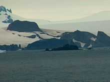 Kabile Island from English Strait. | |
 Location of Greenwich Island in the South Shetland Islands. | |
| Geography | |
|---|---|
| Location | Antarctica |
| Coordinates | 62°26′26″S 59°56′35″W / 62.44056°S 59.94306°W |
| Archipelago | South Shetland Islands |
| Area | 19 ha (47 acres)[1] |
| Length | 0.7 km (0.43 mi) |
| Country | |
| Demographics | |
| Population | 0 |
| Additional information | |
| Administered under the Antarctic Treaty System | |
Kabile Island (Ostrov Kabile 'os-trov ka-bi-'le) is an Antarctic island extending 700 m (770 yd) in south-north direction and 450 m (490 yd) wide, situated off the north coast of Greenwich Island in the South Shetland Islands, Antarctica. Surface area 19 hectares (47 acres).[1]
Named after the ancient Thracian town of Kabile near the present Bulgarian city of Yambol.[2]
Location
The island is located at 62°26′30″S 59°56′33″W / 62.44167°S 59.94250°W which is 950 m (1,040 yd) east of Pavlikeni Point, 1 km (0.62 mi) north of Crutch Peaks, 200 m (220 yd) northwest of Miletich Point, and 2.5 km (1.6 mi) west-southwest of Ongley Island (Chilean mapping in 1966, British mapping in 1968 and Bulgarian in 2009).
See also
- Composite Antarctic Gazetteer
- List of Antarctic islands south of 60° S
- SCAR
- Territorial claims in Antarctica
References
- ↑ 1.0 1.1 L.L. Ivanov. Antarctica: Livingston Island and Greenwich, Robert, Snow and Smith Islands. Scale 1:120000 topographic map. Troyan: Manfred Wörner Foundation, 2009. ISBN 978-954-92032-6-4
- ↑ SCAR Composite Antarctic Gazetteer: Kabile Island.
External links
This article includes information from the Antarctic Place-names Commission of Bulgaria which is used with permission.