K-43 (Kansas highway)
| ||||
|---|---|---|---|---|
 | ||||
| Route information | ||||
| Maintained by KDOT | ||||
| Length: | 20.718 mi[1] (33.342 km) | |||
| Existed: | c. 1932[2] – present | |||
| Major junctions | ||||
| South end: |
| |||
| North end: |
| |||
| Location | ||||
| Counties: | Dickinson | |||
| Highway system | ||||
| ||||
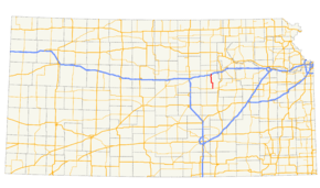
K-43 is a 20.718-mile-long (33.342 km) state highway in the U.S. state of Kansas. The highway runs from K-4 in Hope north to Interstate 70 (I-70) and U.S. Route 40 (US-40) north of Detroit. The entire highway is located within Dickinson County. K-43 is maintained by the Kansas Department of Transportation (KDOT), and is a relatively minor highway. K-43 is not part of the National Highway System. The highway was established around 1932, with the northern terminus being the now decommissioned US-40S. In 1962, the route was extended north a bit to a new diamond interchange with I-70.
Route description
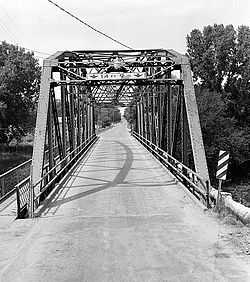
K-43 begins at an intersection with K-4 at the northern city limit of Hope. The highway heads north for about seven miles (11 km) before turning west and entering the small community of Navarre. The route crosses the BNSF Railway[3] and turns to the north, continuing through flat farmland. The highway crosses the railway again before entering the city of Enterprise. In Enterprise, K-43 turns east along 5th Street, then north onto Factory Street. The highway curves northwest and crosses the BNSF Railway a third time before crossing the Smoky Hill River on a 160-foot-long (49 m) truss bridge constructed in 1924.[4]
Upon crossing this bridge, K-43 leaves Enterprise. The route bends to the north and crosses the BNSF Railway a fourth and final time. Continuing north through level plains, K-43 meets a railroad operated by Union Pacific[3] and comes to an intersection with its former northern terminus at an old alignment of US-40.[2] At this intersection, the route turns to the northeast and travels through the community of Detroit before turning back to the north. North of here, K-43 meets its northern terminus at a diamond interchange with I-70 and US-40.[5][6]

K-43 is maintained by the Kansas Department of Transportation (KDOT). The traffic numbers on the route in 2012, measured in annual average daily traffic, were relatively low compared to other state highways. Between 185 and 1900 vehicles traveled the highway each day, including between 30 and 95 trucks. The most traffic was present in the segment of the highway between Enterprise and Detroit.[7] No segment of K-43 is included in the National Highway System,[8] a system of highways considered to be important to the nation's defense, economy, and mobility.[9]
History
K-43 first appears on the 1932 state highway map. At that time it followed largely the same alignment it does today, running from K-4 in Hope to an intersection with what was then US-40S. Most of the road was dirt, but it was paved with gravel from Enterprise north to its northern terminus.[2] By 1936, the whole route had been upgraded to gravel pavement.[10][11] In 1945, the portion north of Enterprise was paved.[12][13] The entire highway had been paved by 1956.[14][15] In 1962, the highway was extended slightly to the north, moving its northern terminus from US-40 to an interchange with the newly constructed I-70.[16][17] The route has not changed significantly since 1962.[18]
Major intersections
The entire route is in Dickinson County.
| Location | Mile[1] | km | Destinations | Notes | |
|---|---|---|---|---|---|
| Hope | 0.000 | 0.000 | |||
| Center Township | 20.718 | 33.342 | |||
| 1.000 mi = 1.609 km; 1.000 km = 0.621 mi | |||||
References
- ↑ 1.0 1.1 "2009 Condition Survey Report". Pavement Management System. Kansas Department of Transportation. Retrieved February 27, 2011.
- ↑ 2.0 2.1 2.2 State Highway Commission of Kansas. Kansas State Highway System (Map) (1932 ed.). http://www.ksdot.org/burtransplan/maps/HistoricStateMaps/1932Mapside.pdf. Retrieved February 5, 2013.
- ↑ 3.0 3.1 "Kansas Railroad Map 2011". Kansas Department of Transportation. April 1, 2011. Retrieved February 9, 2013.
- ↑ "Enterprise Parker Truss Bridge". Historical American Engineering Record. National Park Service. Retrieved February 9, 2013.
- ↑ Kansas Department of Transportation (2010). Dickinson County, Kansas General Highway Map (Map). http://www.ksdot.org/burtransplan/maps/county-dgn/dickinson.jpg. Retrieved February 27, 2011.
- ↑ Google Inc. "K-43 (Kansas highway)". Google Maps (Map). Cartography by Google, Inc. http://maps.google.com/maps?f=d&source=s_d&saddr=KS-43+N&daddr=KS-43+N%2FMink+Rd%2FMink+Rd+1500&hl=en&geocode=FXx0TgIdXL42-g%3BFS10UgIdRzE2-g&mra=me&mrsp=1,0&sz=18&sll=38.957411,-97.111797&sspn=0.002165,0.006866&ie=UTF8&ll=38.83008,-97.055283&spn=0.277613,0.878906&t=h&z=11. Retrieved February 27, 2011.
- ↑ "2012 Traffic Flow Map of the Kansas State Highway System". Kansas Department of Transportation. Retrieved February 8, 2013.
- ↑ "National Highway System: Kansas". Federal Highway Administration. October 1, 2012. Retrieved February 8, 2013.
- ↑ Natzke, Stefan; Neathery, Mike; Adderly, Kevin (September 26, 2012). "What is the National Highway System?". National Highway System. Federal Highway Administration. Retrieved January 15, 2013.
- ↑ "Kansas State Highway System" (1933 ed.). State Highway Commission of Kansas. Retrieved February 7, 2013.
- ↑ "Kansas State Highway System" (1936 ed.). State Highway Commission of Kansas. Retrieved February 5, 2013.
- ↑ "Kansas State Highway System" (1941 ed.). State Highway Commission of Kansas. Retrieved February 7, 2013.
- ↑ "Kansas State Highway System" (1945 ed.). State Highway Commission of Kansas. Retrieved February 6, 2013.
- ↑ "Official 1953 Kansas Highway Map". State Highway Commission of Kansas. Retrieved February 7, 2013.
- ↑ "Official 1956 Kansas Highway Map". State Highway Commission of Kansas. Retrieved February 6, 2013.
- ↑ "Official 1961 Kansas Highway Map". State Highway Commission of Kansas. Retrieved February 7, 2013.
- ↑ "Official 1962 Kansas Highway Map". State Highway Commission of Kansas. Retrieved February 7, 2013.
- ↑ Kansas Department of Transportation. Kansas Official State Transportation Map (Map) (2013-14 ed.). http://www.ksdot.org/burtransplan/maps/HistoricStateMaps/2013-14Mapside.pdf. Retrieved February 7, 2013.
External links
Route map: Google / Bing| KML file (edit) |
