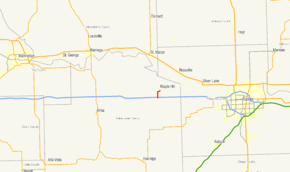
K-30 (Kansas highway)
| ||||
|---|---|---|---|---|
 | ||||
| Route information | ||||
| Maintained by KDOT | ||||
| Length: | 1.950 mi[1] (3.138 km) | |||
| Existed: | 1950[2] – present | |||
| Major junctions | ||||
| South end: |
| |||
| North end: | Southern city limit of Maple Hill | |||
| Highway system | ||||
| ||||
K-30 is a 1.95-mile-long (3.14 km) state highway running from Interstate 70 (I-70) north to the southern city limit of Maple Hill. A previous designation existed in the late 1920s which was removed by 1932. It existed in Jefferson County. The current route was established in the early 1950s.
Route description
The route begins at an interchange with I-70, which also carries US 40, at that freeway's exit 341.[3] The road continues southward as Windy Hill Road toward Eskridge. From I-70, K-30 crosses the Mill Creek before intersecting Waterman Crossing Road.[4] The road then crosses a railroad owned by Union Pacific before abruptly turning to the east.[5] K-30 warps slightly northeast, running parallel to the railway line. Following an intersection with Sunset Lane, the highway picks up the name of Elm Street as it runs along the southern city limit of Maple Hill. The roadway ends near an intersection with Main Street.[6]
The route is maintained by the Kansas Department of Transportation (KDOT). In 2010, KDOT calculated that the route's annual average daily traffic was 1420 vehicles, including 85 trucks.[7] No segment of the highway is part of the National Highway System.[8]
History
A previous designation for K-30 was brought into the Kansas state highway system by 1927. The route connected US 40 in Tonganoxie to US 73W in Oskaloosa. At that time, it was only a graded road.[9] This designation was removed by 1932.[10] The current designation of K-30 was established in 1950, from K-10 to Maple Hill, when it was only a gravel road.[2] In 1953, the route was paved.[11][12] In 1960, I-70 was completed through the region, replacing K-10.[13] Since then, the route has not been realigned.[6]
Major intersections
The entire route is in Maple Hill Township, Wabaunsee County.
| Mile[1] | km | Destinations | Notes | ||
|---|---|---|---|---|---|
| 0.000 | 0.000 | Interchange, southern terminus | |||
| 1.950 | 3.138 | Maple Hill city limit | Northern terminus | ||
| 1.000 mi = 1.609 km; 1.000 km = 0.621 mi | |||||
References
- ↑ 1.0 1.1 Kansas Department of Transportation. "2010 Condition Survey Report for Wabaunsee County, Kansas". Retrieved March 31, 2011.
- ↑ 2.0 2.1 Kansas State Highway Commission (1950-1951). Kansas State Highway Map (Map).
- ↑ Federal Highway Administration. "NBI Structure Number 999903000990871". National Bridge Inventory. Retrieved March 31, 2011.
- ↑ Federal Highway Administration. "NBI Structure 999903000990791". National Bridge Inventory. Retrieved March 31, 2011.
- ↑ Kansas Department of Transportation (April 1, 2011). Kansas State Railroad Map (Map). Cartography by Bureau of Transportation Planning. http://www.ksdot.org/BurTransPlan/maps/RRStateMap.asp. Retrieved April 1, 2011.
- ↑ 6.0 6.1 Google Inc. "K-30". Google Maps (Map). Cartography by Google, Inc. http://maps.google.com/maps?f=d&source=s_d&saddr=KS-30+N&daddr=Elm+St&hl=en&geocode=FQb3UwIdAo5G-g%3BFYhTVAIdhb9G-g&mra=me&mrsp=1,0&sz=18&sll=39.081407,-96.027085&sspn=0.00294,0.004823&ie=UTF8&ll=39.066581,-96.026516&spn=0.047048,0.077162&z=14. Retrieved April 1, 2011.
- ↑ Kansas Department of Transportation (2011). Traffic Flow Map of the Kansas State Highway System (Map). Cartography by Bureau of Transportation Planning.
- ↑ Federal Highway Administration (PDF). National Highway System: Kansas (Map). http://www.fhwa.dot.gov/planning/nhs/maps/ks/ks_kansas.pdf. Retrieved March 30, 2011.
- ↑ Rand McNally, retrieved from David Rumsey Map Collection (1927). Junior Auto Road Map of Kansas (Map). http://www.davidrumsey.com/luna/servlet/detail/RUMSEY~8~1~33758~1171474:Rand-McNally-junior-auto-road-map-K?sort=Pub_List_No_InitialSort%2CPub_Date%2CPub_List_No%2CSeries_No&qvq=w4s:/when/1927/;q:Kansas;sort:Pub_List_No_InitialSort%2CPub_Date%2CPub_List_No%2CSeries_No;lc:RUMSEY~8~1&mi=0&trs=2. Retrieved April 1, 2011.
- ↑ Kansas State Highway Commission (April 1, 1932). Kansas State Highway System (Map). Cartography by D. P. Walker.
- ↑ Kansas State Highway Commission (1952). Kansas Official Highway Map (Map). Section C10.
- ↑ Kansas State Highway Commission (1953). Kansas Official Highway Map (Map). Section C10.
- ↑ Kansas State Highway Commission (1960). Kansas Official Highway Map (Map). Section C10.
External links
Route map: Google / Bing| KML file (edit) |
