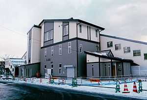
Kōma Station (Iwate)
Kōma Station 好摩駅 | |
 | |
|---|---|
| Kōma Station in December 2011 | |
| Location | |
| Prefecture | Iwate (See other stations in Iwate) |
| City | Morioka |
| Ward | Tamayama |
| Neighborhood etc. | Kōma-aze Kamiyama 2-14 |
| Postal code | 028 - 4125 |
| (in Japanese) | 岩手県盛岡市玉山区好摩字上山2-14 |
| History | |
| Year opened | 1891 |
| Rail services | |
| Operator(s) | Iwate Ginga Railway JR East |
| Line(s) | Iwate Ginga Railway Line Hanawa Line |
| Statistics | 2,096 passengers/day (FY2012) |
Kōma Station (好摩駅 Kōma-eki) is a union railway station in Morioka, Iwate Prefecture Japan, jointly operated by East Japan Railway Company (JR East) and the Iwate Ginga Railway Company.
Lines
Kōma Station is a terminal station on the Hanawa Line, and is located 106.9 rail kilometers from the opposing terminus of the line at Ōdate Station in Akita Prefecture. However, most trains continue on to Morioka Station. It is also a station on the Iwate Ginga Railway Line, and is located 21.3 rail kilometers from the terminus of the line at Morioka Station.
Station layout
Kōma Station is an elevated station with a single side platform and single island platform serving three tracks.
Platforms
| 1 | ■■Iwate Ginga Railway Line | For Morioka |
| ■Hanawa Line | For Ōbuke, Araya-Shinmachi and Kazuno-Hanawa | |
| 2 | ■Iwate Ginga Railway Line | For Iwate-Numakunai, Ninohe and Hachinohe |
| 3 | ■Iwate Ginga Railway Line | For Morioka and Kitakami |
Adjacent stations
| « | Service | » | ||
|---|---|---|---|---|
| Iwate Ginga Railway | ||||
| Shibutami | Express | Iwate-Kawaguchi | ||
| Shibutami | Local | Iwate-Kawaguchi | ||
| Hanawa Line | ||||
| Ōbuke | Rapid Hachimantai | Terminus | ||
| Higashi-Ōbuke | Local | Terminus | ||
History
Kōma Station opened on September 1, 1891 serving the village of Tamayama, Iwate. A new station building was completed in May 2011.
Surrounding area
- National Route 4
- Kōma Post office
References
External links
| Wikimedia Commons has media related to Kōma Station (Iwate). |
- Iwate Ginga Railway Station information (Japanese)
- JR East Station information (Japanese)
| |||||
| |||||
Coordinates: 39°52′27.2″N 141°10′24.5″E / 39.874222°N 141.173472°E