Königsbrunn
From Wikipedia, the free encyclopedia
| Königsbrunn | ||
|---|---|---|
| ||
 Königsbrunn | ||
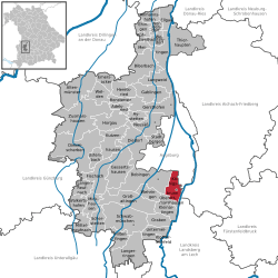
Location of Königsbrunn within Augsburg district  | ||
| Coordinates: 48°16′8″N 10°53′27″E / 48.26889°N 10.89083°ECoordinates: 48°16′8″N 10°53′27″E / 48.26889°N 10.89083°E | ||
| Country | Germany | |
| State | Bavaria | |
| Admin. region | Schwaben | |
| District | Augsburg | |
| Government | ||
| • Mayor | Ludwig Fröhlich (CSU) | |
| Area | ||
| • Total | 18.40 km2 (7.10 sq mi) | |
| Elevation | 516 m (1,693 ft) | |
| Population (2012-12-31)[1] | ||
| • Total | 27,177 | |
| • Density | 1,500/km2 (3,800/sq mi) | |
| Time zone | CET/CEST (UTC+1/+2) | |
| Postal codes | 86343 | |
| Dialling codes | 08231 | |
| Vehicle registration | A | |
| Website | www.koenigsbrunn.de | |
Königsbrunn is a municipality and the largest town in the district of Augsburg, in Bavaria, Germany. It is situated on the left bank of the Lech, approx. 10 km south of Augsburg.
History
Königsbrunn is one of the youngest settlements in Bavaria. It became an independent commune in 1842 and obtained the municipal law 125 years later, in 1967. In 1688 the bishop built a custom house at the crossroad of Via Claudia, which is called the "Neuhaus" (meaning new house). It is the oldest building of the young city.
Politics
Seating in the city council (Since local elections 2008):
- CSU: 17 seats
- SPD: 4 seats
- Freie-Wähler-Gruppe: 4 seats
- GRÜNE: 3 seats
- FDP/Bürgerforum: 2 seats
Ludwig Fröhlich (CSU)is mayor of Königsbrunn since 1996.
Attractions
- Mercateum, the worlds biggest globe to rely on a historical map
- Mithräum
References
- ↑ "Fortschreibung des Bevölkerungsstandes". Bayerisches Landesamt für Statistik und Datenverarbeitung (in German). 31 December 2012.
External links
This article is issued from Wikipedia. The text is available under the Creative Commons Attribution/Share Alike; additional terms may apply for the media files.
