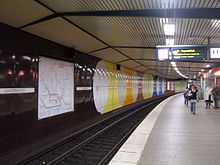
Jungfernstieg station
Rapid transit transport hub | |||||||||||||||||||||||||||||||||||||||||
|---|---|---|---|---|---|---|---|---|---|---|---|---|---|---|---|---|---|---|---|---|---|---|---|---|---|---|---|---|---|---|---|---|---|---|---|---|---|---|---|---|---|
 Jungfernstieg station, entrance Alsterarkaden. | |||||||||||||||||||||||||||||||||||||||||
| Station statistics | |||||||||||||||||||||||||||||||||||||||||
| Address |
Neuer Wall Hamburg, Germany | ||||||||||||||||||||||||||||||||||||||||
| Connections |
Bus, U3 (Rathaus), Alster boat trips | ||||||||||||||||||||||||||||||||||||||||
| Levels | 3 | ||||||||||||||||||||||||||||||||||||||||
| Platforms | 4 | ||||||||||||||||||||||||||||||||||||||||
| Tracks | 6 | ||||||||||||||||||||||||||||||||||||||||
| Baggage check | No | ||||||||||||||||||||||||||||||||||||||||
| Other information | |||||||||||||||||||||||||||||||||||||||||
| Opened |
U-Bahn: (U1 line) 25 March 1931 S-Bahn: 1 June 1975 | ||||||||||||||||||||||||||||||||||||||||
| Electrified |
U Bahn: 750 volts DC system Bottom-contact third rail S-Bahn: 1200 volts DC system Third rail | ||||||||||||||||||||||||||||||||||||||||
| Station code |
S-Bahn: ds100: AJUS DB station code: 3086 Type: Hp Category: 4[1] | ||||||||||||||||||||||||||||||||||||||||
| Owned by |
Hamburger Hochbahn S-Bahn Hamburg plc | ||||||||||||||||||||||||||||||||||||||||
| Fare zone | 000 | ||||||||||||||||||||||||||||||||||||||||
| Services | |||||||||||||||||||||||||||||||||||||||||
| |||||||||||||||||||||||||||||||||||||||||
| Location | |||||||||||||||||||||||||||||||||||||||||
 Jungfernstieg station Jungfernstieg station (Hamburg)
| |||||||||||||||||||||||||||||||||||||||||
Jungfernstieg is an underground railway station[1] in the city centre of Hamburg, Germany, serviced by the underground railway (U-Bahn) and the City S-Bahn line of the suburban railway (S-Bahn). The station is located in the Hamburg-Mitte borough under the artificial lake Binnenalster and named after a street of the same name.
History
On 25 March 1931, the underground railway line Kellinghusenstr–Jungfernstieg — now part of the U1 — was opened. In 1958, the underground platforms between the Circle Line's Rathaus station (now U3) and Jungfernstieg station were connected. In 1973, the diameter line U2 was completed between Gänsemarkt and Hauptbahnhof Nord, and on 1 June 1975, the Hamburg S-Bahn opened the first section of their so-called "City-S-Bahn" between Hauptbahnhof and Landungsbrücken.
Layout
It is an underground station with two island platforms and two side platforms on three different levels. The rapid transit trains of the Hamburg S-Bahn system serve one island platform, the other island platform is served by the Hamburg U-Bahn line U1, and the line U2 serves the two side platforms. The U3 Rathaus underground station is connected with a pedestrian underpass.[2] Toilets and shops are located at the station, but the station is not accessible for handicapped persons.[3]
-
Jungfernstieg S-bahn
-

Jungfernstieg
-
Line U4 Jungfernstieg station
-

Platforms for line U2 and U4
Services
No personnel is attending the station, but there are ticket machines, CCTV, and SOS / information telephones.[3]
Trains
The lines S1, S2 and S3 of the Hamburg S-Bahn and the lines U1 and U2 of the Hamburg U-Bahn serve the Jungfernstieg station.[4]
It is planned to open the new U-Bahn line U4 to the HafenCity quarter in 2011. It will serve the platforms at the deepest level side by side with U2 line.
Buses
Several bus routes call at bus stops on the streets above the station.[2][3]
See also
References
- ↑ 1.0 1.1 Name, station code and category: Liste Bahnhofskategorie 2008, DB Station&Service AG, Köthener Straße 2, 10963 Berlin (2008) (German)
- ↑ 2.0 2.1 Tunnelplan (in German), www.nimmbus.de, 2007, retrieved 2009-03-26
- ↑ 3.0 3.1 3.2 DB-Konzern Jungfernstieg (in German), Deutsche Bahn, 2009, retrieved 2009-03-26
- ↑ Rapid Transit/Regional Rail, Hamburger Verkehrsverbund, 2008-12-14, retrieved 2009-03-26
External links
| Wikimedia Commons has media related to Schnellbahnknoten Jungfernstieg. |
- U-Bahn Hamburg line U4 website (German)
| ||||||||||||||
Coordinates: 53°33′13″N 9°59′33″E / 53.55361°N 9.99250°E

