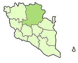
Jerantut
| Jerantut ﺟﺮﻧﺘﻮﺕ | |
|---|---|
| District of Malaysia | |
 | |
| Country |
|
| State |
|
| Seat | Jerantut |
| Government | |
| • District officer | Roslan |
| Area | |
| • Total | 7,561 km2 (2,919 sq mi) |
| Population (2004) | |
| • Total | 90,000 |
| • Density | 12/km2 (31/sq mi) |
Jerantut is a major town in central Pahang, Malaysia. It is located 200 kilometres from Kuala Lumpur, and 180 km from Kuantan. Jerantut is also the capital of the district of the same name. Located in the north of Pahang state, Jerantut is the main entrance to the National Park. Being the largest district in Pahang, it bounds the northern states of Kelantan and Terengganu, in the south, Temerloh and Maran district, in the west, Lipis and Raub district and in the east, Kuantan district. Tembeling River, the main river in this district is the exciting way to National Park and the surrounding villages in Ulu Tembeling. The joining of Tembeling and Jelai river forms the Pahang river where it flows right through the Royal Pekan town and then through the South China Sea.
Federal Parliament and State Assembly Seats
Jerantut district representative in the Federal Parliament (Dewan Rakyat)
| Parliament | Seat Name | Member of Parliament | Party |
|---|---|---|---|
| P81 | Jerantut | Cikgu Ahmad Nazlan | BN |
List of Jerantut district representatives in the State Legislative Assembly (Dewan Undangan Negeri)
| Parliament | State | Seat Name | State Assemblyman | Party |
|---|---|---|---|---|
| P81 | N9 | Tahan | Wan Amizan Wan Abdul Razak | BN |
| P81 | N10 | Damak | Lau Lee | BN |
| P81 | N11 | Pulau Tawar | Ahmad Shukri Ismail | BN |
Subdistricts
Jerantut has 10 mukim or subdistricts.
- Hulu Tembeling (416,897 Ha)
- Tembeling Tengah (135,718 Ha)
- Pulau Tawar (84,435 Ha)
- Tebing Tinggi (33,400 Ha)
- Hulu Cheka (29,000 Ha)
- Pedah (24,600 Ha)
- Burau (12,120 Ha)
- Kuala Tembeling (10,778 Ha)
- Teh (9,563 Ha)
- Kelola (6,248 Ha)
Recreational park
Jerantut is a gateway to Taman Negara, the first national park in Malaysia. It is also possible to visit another nearby nature park - Kenong Rimba Park.
The Kota Gelanggi caves are about 25 kilometre east of Jerantut. Many of these caves are archaeological sites, and several caves are now open to the public. As well as caves, there are other tourist attractions such as Lata Meraung Waterfall, Orang Asli Settlement, Gunung Tahan, Gunung Benom and Rafflesia Conservation Center.
Transportation
The Jerantut KTM railway station is one of the major stations of KTM's East Coast Line. KTM intercity and express trains stop at this station. Visitors to Taman Negara can disembark from here.
Villages
- Mukim Pulau Tawar
- Mukim Ulu Tembeling
- Mukim Kuala Tembeling
- Mukim Teh
- Mukim Damak
- Mukim Pedah
- Mukim Ulu Cheka
- Mukim Burau
- Felda Kota Gelanggi 1
- Felda Kota Gelanggi 2
- Felda Kota Gelanggi 3
- Felda Kota Gelanggi 4
- Felda Agriculture Kota Gelanggi 5&6
- Felda Sungai Tekam
- Felda Sungai Tekam Utara
Schools
Primary schools
- Sekolah Rendah Jenis Kebangsaan Cina Sg. Jan Jerantut
- Sekolah Kebangsaan Bandar Jerantut
- Sekolah Kebangsaan Perian
- Sekolah Kebangsaan Pulau Tawar
- Sekolah Kebangsaan Pulau Mansok
- Sekolah Kebangsaan Bukit Nikmat
- Sekolah Kebangsaan Temin
- Sekolah Kebangsaan Jerantut
- Sekolah Kebangsaan Damak
- Sekolah Kebangsaan Pawang Nong, Hulu Cheka
- Sekolah Kebangsaan Felda Padang Piol
- Sekolah Kebangsaan Felda Sungai Retang
- Sekolah Kebangsaan Kuala Tahan
- Sekolah Rendah Jenis Kebangsaan Cina Damak
- Sekolah Kebangsaan Felda Sungai Tekam Utara & Sungai Tekam Getah
- Sekolah Kebangsaan Kota Gelanggi (1,2 & 3)
- Sekolah Kebangsaan Kampung Baru
- Sekolah Rendah Jenis Kebangsaan Cina batu balai
- Sekolah Rendah Jenis Kebangsaan Cina jeransong
- Sekolah Kebangsaan batu balai
Secondary schools
- Sekolah Menengah Kebangsaan Jerantut.
- Sekolah Menengah Kebangsaan Padang Saujana (SMKPS or Saujana)
- Sekolah Menengah Temin
- Sekolah Menengah Agama Pulau Tawar
- Sekolah Menengah Pulau Tawar
- Sekolah Menengah Kebangsaan Damak
- Sekolah Menengah Inderapura
- Sekolah Menengah Kebangsaan Agama Tengku Ampuan Hajah Afzan Pahang (TAHAP)
- Sekolah Menengah Kebangsaan Felda Padang Piol
- Sekolah Menengah Kebangsaan Felda Sungai Retang
- Sekolah Menengah Kebangsaan Jubli Perak Sultan Haji Ahmad Shah
- Sekolah Menengah Kota Gelanggi 2
External links
| |||||||||||||||||||||||
Coordinates: 3°56′N 102°22′E / 3.933°N 102.367°E