Jawor
From Wikipedia, the free encyclopedia
For other places with the same name, see Jawor (disambiguation).
| Jawor | ||
|---|---|---|
 | ||
| ||
 Jawor | ||
| Coordinates: 51°03′N 16°12′E / 51.050°N 16.200°E | ||
| Country |
| |
| Voivodeship | Lower Silesian | |
| County | Jawor County | |
| Gmina | Jawor (urban gmina) | |
| Government | ||
| • Mayor | Artur Mieczysław Urbański | |
| Area | ||
| • Total | 18.8 km2 (7.3 sq mi) | |
| Population (2006) | ||
| • Total | 24,347 | |
| • Density | 1,300/km2 (3,400/sq mi) | |
| Time zone | CET (UTC+1) | |
| • Summer (DST) | CEST (UTC+2) | |
| Postal code | 59-400 | |
| Car plates | DJA | |
| Website | http://www.jawor.pl | |
Jawor [ˈjavɔr] (German: Jauer) is a town in south-western Poland with 24,347 inhabitants (2006). It is situated in Lower Silesian Voivodeship (from 1975–1998 it was in the former Legnica Voivodeship). It is the seat of Jawor County, and lies approximately 61 kilometres (38 mi) west of the regional capital Wrocław.
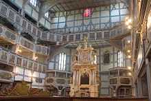
In the town can be found a Protestant Church of Peace. It was named a UNESCO World Heritage Site in 2001.
The name Jawor is Polish for "sycamore". Prior to 1945, the town was part of Poland, Bohemia, Austria, Prussia and Germany.
-

Church of Peace
-

Church of Peace, interior
-
Buildings in Jawor
-
Jawor old market square
External links
- Official site
- Local flags
- Jewish Community in Jawor on Virtual Shtetl
- Church Of Peace in Jawor - photo gallery
| Wikimedia Commons has media related to Jawor. |
Coordinates: 51°03′N 16°12′E / 51.050°N 16.200°E
| |||||||||||||
This article is issued from Wikipedia. The text is available under the Creative Commons Attribution/Share Alike; additional terms may apply for the media files.


