Jakobselva (Sør-Varanger)
From Wikipedia, the free encyclopedia
| Jakobselva | |
| Ворьема / Vuoremijoki / Vuorján | |
| River | |
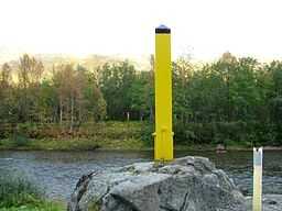
 View of the border markers along the river | |
| Countries | Norway, Russia |
|---|---|
| Regions | Finnmark county, Murmansk Oblast |
| Source | Vuorjánláđvi |
| - location | Grensefjellet, Finnmark, Norway |
| - elevation | 344 m (1,129 ft) |
| - coordinates | 69°32′47″N 30°42′09″E / 69.54639°N 30.70250°E |
| Mouth | Varangerfjorden |
| - location | Grense Jakobselv, Finnmark, Norway |
| - elevation | 0 m (0 ft) |
| - coordinates | 69°46′53″N 30°49′08″E / 69.78139°N 30.81889°E |
| Length | 45 km (28 mi) |
| Basin | 236.44 km2 (91 sq mi) |
| Discharge | |
| - average | 4.13 m3/s (146 cu ft/s) |
Jakobselva or Grense Jakobselv River (English: Jacob's River, Russian: Ворьема, Finnish: Vuoremijoki, Northern Sami: Vuorján) is a river that runs along the Russia-Norway border. The river runs along the border of Sør-Varanger Municipality in Finnmark county, Norway, and Pechengsky District in Murmansk Oblast, Russia. The river discharges into the Varangerfjorden, a bay off the Barents Sea.[1]
This river is known as a superb salmon fishing river, but where the river forms the border only Norwegian citizens and long-term residents of Norway are permitted to fish, and then only on the Norwegian side of the river.[2]
The Jakobselva lends its name to the small village of Grense Jakobselv, near the mouth of the river in Norway.
References
- ↑ Store norske leksikon. "Jakobselva" (in Norwegian). Retrieved 2013-03-16.
- ↑ "Conduct and Travel at the Norwegian - Russian Border". Norges Grensekommissær.
This article is issued from Wikipedia. The text is available under the Creative Commons Attribution/Share Alike; additional terms may apply for the media files.