Jaci, São Paulo
From Wikipedia, the free encyclopedia
Coordinates: 20°52′56″S 49°34′12″W / 20.88222°S 49.57000°W
| Map | |
|---|---|
 | |
| Statistics | |
| State: | São Paulo |
| Meso-region: | São Jose do Rio Preto |
| Micro-Region: | São Jose do Rio Preto |
| Founded: | April 8, 1875 |
| Location: | 20.98/20° 52' 56" S lat. 49.6705/49° 34' 12" W long. |
| Area: | 144.4 km² |
| Population (2003): - Total - Change - Density | 4,568 - 31.53/km² |
| Elevation: | 545 m |
| Postal code: | 90-xxx |
| Distance from the capital: | - |
| Website: | www.jaci.sp.gov.br |
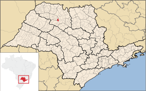
Jaci is a municipality in the state of São Paulo in Brazil. The population in 2004 was 4,568 and the area is 144.88 km². The elevation is 545 m. The place name comes from the Tupi language.
Demographics
The 2000 population was 5,117, of which 3,973 were urban and 1,144 were rural. The life expectancy was 73.8 years. The literacy rate was at 87.42%.
Population
| Year | Population | Change | Density |
|---|---|---|---|
| 2000 | 5,117 | - | 28.51/km² |
| 2004 | 4,568 | -549 or -10.73% | 31.53/km² |
Other
Jaci has a school or a collegiate, churches and a few squares and parks.
External links
- http://www.citybrazil.com.br/sp/jaci/ (Portuguese)
This article is issued from Wikipedia. The text is available under the Creative Commons Attribution/Share Alike; additional terms may apply for the media files.