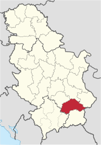
Jablanica District
| Jablanica District Јабланички округ Jablanički okrug | |
|---|---|
| District of Serbia | |
 | |
| Country |
|
| Administrative centre | Leskovac |
| Government | |
| • Commissioner | n/a |
| Area | |
| • Total | 2,769 km2 (1,069 sq mi) |
| Population (2011 census) | |
| • Total | 215,463 |
| • Density | 77.8/km2 (202/sq mi) |
| Municipalities | 5 and 1 city |
| Settlements | 336 |
| – Cities and towns | 7 |
| – Villages | 329 |
The Jablanica District (Serbian: Јабланички округ / Jablanički okrug) expands in the south eastern parts of Serbia. It has a population of 215,463. The administrative centre of the district is Leskovac, the biggest settlement in south Serbia.
Municipalities
The district encompasses the municipalities of:
Ethnic groups (2002 census)
- Serbs = 225,092
- Roma = 9,900
- Albanians = 2,841
- others
History and culture
Famous cultural-historic monuments in this District are: the Roman necropolis in Mala Kopasnica originating from 2nd century AD, a late Roman-early Byzantine (6th century AD) town of Caričin Grad or Iustiniana Prima, the Jasunjski Monasteries dedicated to the Virgin of Transfiguration and St. John the Baptist, built in 1499 as the endowment of monastery sister Ksenija, as well as the church of St. John the Baptist from 16th century, being a true pearl among monuments.
Economy
Holders of economic development of the Jablanički District are: Pharmaceutical and chemical industry Zdravlje A.D., plastified tin-plate factory Pobeda, Tomako, meat producer Mesokombinat, "Letex" textile industry, "Nevena" cosmetics industry and others.
See also
| Wikimedia Commons has media related to Jablanica District. |
- Districts of Serbia
- Administrative divisions of Serbia
References
- Note: All official material made by the Government of Serbia is public by law. Information was taken from www.srbija.gov.rs.
 |
|
|
|
 |
| |
|
| ||
| ||||
| | ||||
| |
- ↑ Kosovo is the subject of a territorial dispute between the Republic of Serbia and the Republic of Kosovo. The latter declared independence on 17 February 2008, but Serbia continues to claim it as part of its own sovereign territory. Kosovo's independence has been recognised by 107 out of 193 United Nations member states.
| ||||||||||||||||||||
Coordinates: 43°00′N 21°57′E / 43.000°N 21.950°E