Jēkabpils
| Jēkabpils | |||
|---|---|---|---|
| City | |||
 | |||
| |||
 Jēkabpils | |||
| Coordinates: 56°29′58″N 25°52′42″E / 56.49944°N 25.87833°ECoordinates: 56°29′58″N 25°52′42″E / 56.49944°N 25.87833°E | |||
| Country |
| ||
| Town rights | 1670 | ||
| Government | |||
| • Mayor | Leonīds Salcevičs | ||
| • Number of city council members | 13 | ||
| Area | |||
| • Total | 26.284 km2 (10.148 sq mi) | ||
| Population (1 January 2012)[1] | |||
| • Total | 25,883 | ||
| • Density | 980/km2 (2,600/sq mi) | ||
| Time zone | EET (UTC+2) | ||
| • Summer (DST) | EEST (UTC+3) | ||
| Postal code | LV-52(01–06) | ||
| Calling code | (+371) 652 | ||
| Website | www.jekabpils.lv | ||
Jēkabpils (![]() pronunciation (help·info); German: Jakobstadt; Polish: Jakubów) is a city in southeastern Latvia roughly halfway between Riga and Daugavpils and spanning the Daugava River. Historic Jēkabpils lies on the left bank, in Selonia while historic Krustpils (German: Kreutzburg) lies on the right bank, in Latgale. The two cities were united during Soviet rule in 1962 under the Jēkabpils name, but retain their distinct regional character.
pronunciation (help·info); German: Jakobstadt; Polish: Jakubów) is a city in southeastern Latvia roughly halfway between Riga and Daugavpils and spanning the Daugava River. Historic Jēkabpils lies on the left bank, in Selonia while historic Krustpils (German: Kreutzburg) lies on the right bank, in Latgale. The two cities were united during Soviet rule in 1962 under the Jēkabpils name, but retain their distinct regional character.
Jēkabpils was also formerly home to a Soviet air base.
History
A stone cross-castle — Cruczeborch (German: Kreutzburg) – was built in 1237 by the bishop of Rīga. Archeological excavations on the nearby Asote mound indicate that this place was a busy trading centre for the Latgalians, one of the Latvian tribes, and had been inhabited since 1,000 BC. An adjoining settlement already existed when the castle was first built; it grew up around the castle as the village of Krustpils. The village was often destroyed during local wars, such as Polish-Swedish battles, but was always rebuilt afterward.
During the 17th century persecuted Old Believers from Russia settled along the Daugava river. In 1670 this settlement gradually growing around the Salas tavern became known as Jēkabpils (Jakobstadt in German) in honor of the Duke of Courland, Jacob Kettler, who granted it its city charter.
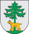
A local legend about the town's origin states that the duke was hunting one day but became lost. At the Daugava River he simultaneously spotted a lynx underneath a fir tree as well as a town at the same time. This image of the lynx underneath a fir tree is the town's coat of arms.
Jēkabpils and Krustpils merged in 1962.
Geography
The population of Jēkabpils town is 29,100. The two historical parts of Jēkabpils — Krustpils and historic Jēkabpils — are connected by the bridge across the Daugava River.
Demographics
As of 1 January 2013, the city had a population of 25,883.
Sights
Jēkabpils
In the oldest part of the town the older buildings have been preserved.
Jēkabpils District
One of the Struve Geodetic Arc original station points is located in Strūves park. In Tadenava, not far from Jēkabpils itself, there is a memorial museum to the great Latvian poet Rainis. There are also the Justine and Dignaja castle sites. The highest point of Selonia – Ormaņkalns — is in Klauce area. Between Nereta and Aknīste there is a memorial museum "Riekstiņi" of famous Latvian writer Jānis Jaunsudrabiņš.
-
Jēkabpils city council
-
Old believers church in Jēkabpils
-
.jpg)
Jēkaba street and Holy Spirit Monastery elements
-
Jēkabpils central square
-
Krustpils railway station in Jēkabpils
-
.jpg)
Krustpils Castle
-

Pļaviņu iela (street) and Daugava River levee
References
- ↑ "Latvijas iedzīvotāju skaits pašvaldībās 01.01.2012. (PDF)". PMLP.gov.lv. Retrieved April 29, 2012. (Latvian)
- ↑
| ||||||||


..JPG)