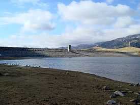
Isabella Dam
| Isabella Dam | |
|---|---|
 Isabella Dam under construction | |
| Location | Kern County, California |
| Coordinates | 35°38′46″N 118°28′56″W / 35.64611°N 118.48222°WCoordinates: 35°38′46″N 118°28′56″W / 35.64611°N 118.48222°W |
| Construction began | 1948 |
| Opening date | 1953 |
| Dam and spillways | |
| Impounds | Lower Kern River |
| Length | 1,695 ft (517 m) |
| Height | 185 ft (56 m) |
| Spillways | Ungated concrete overflow |
| Spillway capacity | 49,000 cu ft/s (1,400 m3/s) |
| Reservoir | |
| Creates | Lake Isabella |
| Total capacity | 568,000 acre·ft (0.701 km3) |
| Catchment area | 2,074 sq mi (5,370 km2) |
| Surface area | 11,000 acres (4,500 ha) |
| Power station | |
| Installed capacity | 12 MW |
Isabella Dam is an embankment dam located about halfway down the Kern River, between the towns of Kernville and Lake Isabella in Kern County, California. Isabella Dam serves agricultural, hydroelectric, and flood control uses.[1]
History
In 1948, Congress appropriated funds to build a dam to prevent flooding of Bakersfield. The city had been flooded in 1867 and 1893. In 1950, while the dam was under construction, they experienced flooding measuring 30,000 cubic feet (850 m3) of water per second.[2] The dam was completed in March 1953.[1][2]
Construction
Isabella Dam actually consists of two dams, a "main dam", and an “auxiliary dam”. The main dam is of earthen build, 1,695 feet (517 m) long and 98 feet (30 m) tall, and owned and maintained by the U.S. Army Corps of Engineers.[1] Normal release from the main dam is 3,000 cubic feet per second (80 m³/s),[2] maximum historical releases were 7,200 ft³/s (200 m³/s) in 1983.[3]
The auxiliary dam is part of the Borel hydroelectric project. The canal for the Borel project diverts water from 5.5 miles (8.9 km) upstream of Isabella Dam.[4]
The reservoir that Isabella Dam creates is called Lake Isabella. Water from Lake Isabella can be used in any of three ways. It is released into the Lower Kern River from the main dam, through the hydroelectric project in the main dam, or through the hydroelectric project in the auxiliary dam. The design capacity of the release channel (the Lower Kern River) is over 8,000 ft³/s (230 m³/s). If Lake Isabella is above 110,000 acre feet (140,000,000 m3), the water can also be diverted into the Borel project at the main dam.[4]
2006 seepage

As of April 28, 2006, a seepage problem was found in the Isabella Auxiliary Dam. Officials determined that it would be necessary to restrict the maximum reservoir elevation to 20 feet (6.1 m) below the spillway, or normal "full" pool. The dam's releases through the outlet were increased, allowing the water to flow at 4,500 ft³/s (130 m³/s).[3]
In May 2006, due to more than average rainfall and snowpack in the mountains,[5] and warmer than average temperatures in the area, the Upper Kern River was filling Lake Isabella faster than officials could lower it. The Lower Kern River was also running higher than normal, and flowing at up to 20 miles per hour (32 km/h) in some parts. State Route 178, which travels through the canyon between Bakersfield and Lake Isabella, became unstable, and one lane was closed due to the high water levels.[6] Some flooding was reported by property owners along the river. Emergency management officials warned that if Isabella Dam were to fail when the reservoir was full, a large part of Bakersfield would be inundated within 2 to 4 hours.
After the news of the seepage, the dam came under further attention due to being situated on a fault line. The fault line was thought to be inactive, but in February 2007, a study by the U.S. Army Corps of Engineers found evidence of at least one earthquake in the last 5,000 years, and therefore judged the fault line as active. With the new information about the fault line, the study said the dam was not likely to be in danger.[7] On November 9, 2007, the Corps of Engineers released the Isabella Dam Consensus Report, that confirmed the high-risk classification of the dam, ranking Isabella Dam among the 6 highest risk and highest priority dams in America,[8] and later elevated it to the highest priority.
On March 12, 2008, local officials brought in a team of emergency response experts, and began work on an evacuation plan in case Isabella Dam were to fail.[9]
See also
References
- ↑ 1.0 1.1 1.2 Lakes Online - Lake Isabella Dam Information
- ↑ 2.0 2.1 2.2 Maturango Museum - Some History of the Indian Wells Valley and surrounding areas in Kern, Inyo, and Mono Counties
- ↑ 3.0 3.1 Kern Valley Sun, Perspective: Lower Kern River not yet as high as in 1983, May 10, 2006
- ↑ 4.0 4.1 USGS, 1996 California Hydrologic Data Report, Borel Canal, 1996
- ↑ KERO-TV, Kern River Especially Dangerous This Year, May 17, 2006
- ↑ Kern Valley Sun, Canyon road along river cracks, May 17, 2006
- ↑ KERO 23, Fault Beneath Isabella Dam Active, February 28, 2007
- ↑ U.S. Army Corps of Engineers, Corps of Engineers Releases External Review Report on Isabella Dam, Release No. PA-07-14, November 9, 2007
- ↑ KBAK-TV, Work starts on evacuation plans in case of Isabella Dam failure, March 12, 2008
External links
- Lakes Online - Lake Isabella Dam Information
- Kern River Valley Revitalization KRVR.org - Lake Isabella Dam Safety Forum
| |||||||||||||||||
| ||||||||||||||