Iringa Airport
From Wikipedia, the free encyclopedia
| Iringa / Nduli Airport Uwanja wa Ndege wa Iringa / Nduli (Swahili) | |||
|---|---|---|---|
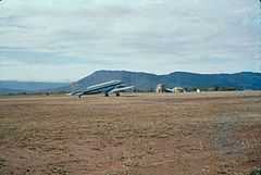 | |||
| Aerodrome in 1960s | |||
| IATA: IRI – ICAO: HTIR – WMO: 63887 | |||
| Summary | |||
| Airport type | Public | ||
| Owner | Government of Tanzania | ||
| Operator | Tanzania Airports Authority | ||
| Serves | Iringa | ||
| Location | Nduli, Tanzania | ||
| Elevation AMSL | 4,678 ft / 1,426 m | ||
| Coordinates | 07°40′10″S 35°45′07″E / 7.66944°S 35.75194°ECoordinates: 07°40′10″S 35°45′07″E / 7.66944°S 35.75194°E | ||
| Map | |||
 IRI | |||
| Runways | |||
| Direction | Length | Surface | |
| m | ft | ||
| 02/20 | 1,670 | 5,479 | Asphalt |
Iringa Airport (IATA: IRI, ICAO: HTIR) is an airport in Tanzania serving Iringa and the surrounding Iringa Region. It is located about 17 kilometres (11 mi) northeast of the municipality. The airport's single runway lies parallel to the A104 trunk road.[1]
Airlines and destinations
| Airlines | Destinations |
|---|---|
| Auric Air | Dar es Salaam, Mbeya[2] |
| Flightlink | Dar es Salaam, Dodoma, Mbeya[3] |
References
- ↑ "List of Aerodromes in Tanzania" (PDF). Tanzania Civil Aviation Authority. Retrieved 5 April 2013.
- ↑ "Flight Schedule" (PDF). Auric Air. 16 December 2012. Retrieved 23 January 2013.
- ↑ "Flight Schedule" (PDF). Flightlink. 1 June 2012. Retrieved 23 January 2013.
External links
| Wikimedia Commons has media related to Iringa Airport. |
| |||||||||||||||||
This article is issued from Wikipedia. The text is available under the Creative Commons Attribution/Share Alike; additional terms may apply for the media files.