Iowa Highway 9
| ||||
|---|---|---|---|---|
 | ||||
| Route information | ||||
| Maintained by Iowa DOT | ||||
| Length: | 295.088 mi[1] (474.898 km) | |||
| Existed: | 1920[2] – present | |||
| Major junctions | ||||
| West end: |
| |||
|
| ||||
| East end: |
| |||
| Location | ||||
| Counties: | Lyon, Osceola, Dickinson, Emmet, Kossuth, Winnebago, Worth, Mitchell, Howard, Winneshiek, Allamakee | |||
| Highway system | ||||
| ||||

Iowa Highway 9 is the most northern of Iowa's east–west highways, traversing the entire northern tier of counties. It runs from the eastern terminus of South Dakota Highway 42 at the South Dakota border east of Sioux Falls, South Dakota near Benclare, to the Wisconsin border at Lansing where it continues as Wisconsin Highway 82. It is largely rural in character, bypassing any large city. Making a few dips north and south, the highway largely follows a very straight east–west alignment.
Route description

Iowa Highway 9 enters from South Dakota as a continuation of South Dakota Highway 42, northwest of Larchwood in Lyon County. It runs south of Lester, at the northern edge of Rock Rapids and south of Little Rock. Crossing into Osceola County, Iowa Highway 60 crosses it just north and slightly west of Sibley. Continuing west, is runs to the north of Ocheyedan. Entering Dickinson County, the highway passes south of Silver Lake and then across the Little Sioux River, into Spirit Lake where it briefly joins U.S. Route 71. It dips southeasterly as it enters Emmet County, continuing into Estherville where it crosses Iowa Highway 4 and a tributary of the Des Moines River. Passing just south of Armstrong it has an intersection with Iowa Highway 15.
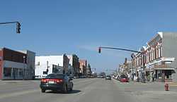
In Kossuth County, it passes through Swea City. East of Swea City, it is joined by U.S. Route 169. It passes north of Lakota, where US 169 turns north. Travelling through Buffalo Center in Winnebago County, takes a slight southwesterly dip to pass northeast of Thompson, continues east, and then south to join U.S. Route 69 at the northern edge of Forest City where it again turns east.

In Worth County, it travels past the northern edges of Fertile and Hanlontown, where it soon crosses Interstate 35. West of I-35, it passes through the south side of Manly.
In Mitchell County, it makes a straight run to and through Osage. It swings back north and resumes going west to Riceville, crossing the Wapsipinicon River in the process.
In Howard County, the highway makes a transition into the Driftless Area of Iowa, with progressively more rugged terrain evident as one travels east. West of Cresco, and south of Lime Springs, it crosses U.S. Route 63 before going through Cresco. In the process, it crosses two tributaries of the Turkey River.
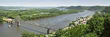
In Winneshiek County, it runs southeasterly, straightening out to go through Decorah in the valley of the Upper Iowa River. In Decorah, it crosses U.S. Route 52. It again takes a southeasterly drift. In Allamakee County, the highway becomes crooked. Just east of the county line, Iowa Highway 51 meets its northern terminus. Running south of Waukon, it then turns north through Waukon, briefly joined by Iowa Highway 76. In the northern part of Waukon, it curves north and east, into Lansing, through the valley of Clear Creek and downtown Lansing. Just before crossing the Mississippi River, it meets the southern terminus of Iowa Highway 26. It then turns onto the Black Hawk Bridge, where it joins Wisconsin Highway 82.
Major intersections
| County | Location | Mile[1] | km | Destinations | Notes |
|---|---|---|---|---|---|
| Lyon | Sioux Township | 0.000 | 0.000 | ||
| Larchwood Township / Logan Township | 7.263 | 11.689 | |||
| Riverside Township / Rock Township | 19.030 | 30.626 | West end of US 75 overlap | ||
| Rock Rapids | 20.021 | 32.221 | East end of US 75 overlap | ||
| Osceola | Wilson Township / East Holman Township | 43.270 | 69.636 | ||
| 46.812 | 75.337 | ||||
| Dickinson | Diamond Lake Township / Lakeville Township | 70.095 | 112.807 | ||
| Spirit Lake | 72.898 | 117.318 | West end of US 71 overlap | ||
| Superior Township / Richland Township | 79.985 | 128.723 | East end of US 71 overlap | ||
| Emmet | Estherville | 88.640 | 142.652 | ||
| Armstrong | 106.496 | 171.389 | West end of Iowa 15 overlap | ||
| 106.611 | 171.574 | East end of Iowa 15 overlap | |||
| Kossuth | Harrison Township | 119.995 | 193.113 | West end of US 169 overlap | |
| Lakota | 126.407 | 203.432 | East end of US 169 overlap | ||
| Winnebago | Newton Township | 149.787 | 241.059 | West end of US 69 overlap | |
| Forest City | 156.810 | 252.361 | East end of US 69 overlap | ||
| Worth | Danville Township | 171.920 | 276.678 | ||
| Manly | 178.931 | 287.962 | |||
| Mitchell | Osage | 199.093 | 320.409 | West end of US 218 overlap | |
| Burr Oak Township | 202.740 | 326.278 | East end of US 218 overlap | ||
| Howard | Howard Center Township | 229.659 | 369.600 | ||
| Vernon Springs Township | 240.645 | 387.281 | |||
| Winneshiek | Decorah | 257.655 | 414.656 | ||
| Allamakee | Ludlow Township | 271.230 | 436.502 | ||
| Jefferson Township | 275.898 | 444.015 | West end of Iowa 76 overlap | ||
| Waukon | 277.903 | 447.242 | East end of Iowa 76 overlap | ||
| Lansing | 294.925 | 474.636 | |||
| Black Hawk Bridge | 295.088 | 474.898 | |||
1.000 mi = 1.609 km; 1.000 km = 0.621 mi
| |||||
References
- ↑ 1.0 1.1 "2011 Volume of Traffic on the Primary Road System of Iowa" (PDF). Iowa Department of Transportation. January 1, 2011. Retrieved January 15, 2011.
- ↑ Rand McNally (1921). Official Auto Trails Map (Map). 1:1,081,344. p. 330-331.
- Iowa Atlas and Gazeteer, 3rd edition, DeLorme, 2004.
- 2007 Transportation Map, Iowa Department of Transportation, 2007.