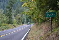
Indiola, Oregon
From Wikipedia, the free encyclopedia
| Indiola | |
|---|---|
| Unincorporated community | |
 | |
 Indiola | |
| Coordinates: 44°8′50″N 123°47′28″W / 44.14722°N 123.79111°WCoordinates: 44°8′50″N 123°47′28″W / 44.14722°N 123.79111°W | |
| Country | United States |
| State | Oregon |
| County | Lane |
| Elevation | 200 ft (60 m) |
| Time zone | Pacific (PST) (UTC-8) |
| • Summer (DST) | PDT (UTC-7) |
| ZIP code | 97453 |
| GNIS feature ID | 1989138 |
Indiola is an unincorporated community in Lane County, Oregon, United States.[1] It is located on Oregon Route 36 about 10 miles (16 km) east of its junction with Oregon Route 126 in Mapleton, near the Siuslaw River.
References
- ↑ "Indiola". Geographic Names Information System, U.S. Geological Survey. July 10, 2003. Retrieved October 5, 2011.
This article is issued from Wikipedia. The text is available under the Creative Commons Attribution/Share Alike; additional terms may apply for the media files.
