Imbabura Province
| Imbabura | |||
|---|---|---|---|
| Province | |||
| Province of Imbabura | |||
 | |||
| |||
 | |||
 | |||
| Country |
| ||
| Capital | Ibarra | ||
| Government | |||
| • Provincial Prefect | Gustavo Pareja (PRIAN) | ||
| Area | |||
| • Total | 4,616 km2 (1,782 sq mi) | ||
| Population (2010)[1] | |||
| • Total | 400,359 | ||
| • Density | 87/km2 (220/sq mi) | ||
| • Population 2001 | 350,946 | ||
| Time zone | ECT | ||
Imbabura is a province in Ecuador. The capital is Ibarra. The people of the province speak Spanish and the Imbaburan Quechua language.
Imbabura Volcano is located in the province. Best reached from the town of La Esperanza, the 4,609-meter-high mountain can be climbed in a single day.
Cantons
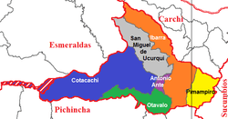
The province is divided into six cantons. The following table lists each with its population as of the 2001 census, its area in square kilometres (km²), and the name of the cantonal seat or capital.[2]
| Canton | Pop. (2001) | Area (km²) | Seat/Capital |
|---|---|---|---|
| Antonio Ante | 36,053 | 81 | Atuntaqui |
| Cotacachi | 37,215 | 1,726 | Cotacachi |
| Ibarra | 153,256 | 1,093 | Ibarra |
| Otavalo | 90,188 | 500 | Otavalo |
| Pimampiro | 12,951 | 437 | Pimampiro |
| San Miguel de Urcuquí | 14,381 | 779 | Urcuquí |
See also
References
- ↑ http://www.inec.gob.ec/preliminares/base_presentacion.html
- ↑ Cantons of Ecuador. Statoids.com. Retrieved 4 November 2009.
Otavalo Indigenous Market: Otavalo is a small city of about 50,000 inhabitants. It lies at 8,300 ft (2,500 m) above sea level in a spring-like valley, situated between the Imbabura volcano (15,118 ft) and the Cotacachi volcano (16,200 ft). The most famous indigenous market in Ecuador is held here. Although the market is bigger on Saturdays, you can visit it any day and find an impressive variety of all kinds of Ecuadorian handcrafts. At dawn you may see indigenous people arriving the market place from many mountain trails surrounding the city. They come from nearby villages and towns such as Peguche, Agato and Iluman, to sell their products. One may visit the workshops of these local weavers working on back strap and Spanish treadle looms, as well as other artisans at work making felt hats, knitting sweaters or weaving straw mats.
- "Volcán Imbabura" (in Spanish). Archived from the original on 2006-08-22.
Coordinates: 0°21′N 78°08′W / 0.350°N 78.133°W

