Ilhéu das Cabras
From Wikipedia, the free encyclopedia
For the island in Guam, see Cabras Island.
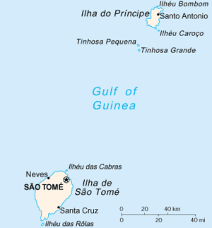 Map of São Tomé and Príncipe with Ilhéu das Cabras north of the island of São Tomé | |
| Geography | |
|---|---|
| Location | north of São Tomé near the urban area of São Tomé, São Tomé and Príncipe |
| Coordinates | 0°24′29″N 6°42′54″E / 0.408°N 6.715°ECoordinates: 0°24′29″N 6°42′54″E / 0.408°N 6.715°E |
| Country | |
| Demographics | |
| Population | 0 |
| Density | 0 /km2 (0 /sq mi) |
| Additional information | |
| Stratovolcano | |
Ilhéu das Cabras is an island in the Gulf of Guinea and is one of the smaller islands of São Tomé and Príncipe. The islet is located just north of the coast of the island of São Tomé north of the city of and east of the island's northernmost point and north of the Água Grande and Lobata district boundary.
| ||||||||
This article is issued from Wikipedia. The text is available under the Creative Commons Attribution/Share Alike; additional terms may apply for the media files.