Hunsrück
| Hunsrück | |
|---|---|
<div style="padding:2px 2px 5px 2px;> | |
| Highest point | |
| Peak | Erbeskopf |
| Elevation | 816 m (2,677 ft) |
| Geography | |
| Country | Germany |
| State/Province | Rhineland-Palatinate |
| Range coordinates | Coordinates: 50°00′N 7°30′E / 50.000°N 7.500°E |
| Geology | |
| Orogeny | Central Uplands |
The Hunsrück (German pronunciation: [ˈhʊnsʁʏk]) is a low mountain range in Rhineland-Palatinate, Germany. It is bounded by the river valleys of the Moselle (north), the Nahe (south), and the Rhine (east). The Hunsrück is continued by the Taunus mountains on the eastern side of the Rhine. In the north behind the Moselle it is continued by the Eifel. To the south of the Nahe, the Palatinate is to be found.
Many of the hills are no higher than 400 m. There are several chains of higher peaks within the Hunsrück, all bearing names on their own: the (Schwarzwälder) Hochwald, the Idarwald, the Soonwald, and the Binger Wald. The highest peak is the Erbeskopf (816 m).
Notable towns located within the Hunsrück include Simmern, Kirchberg, and Idar-Oberstein, Kastellaun, and Morbach. Frankfurt-Hahn Airport, a growing low-fare carrier and cargo airport is also located within the region.
The climate in the Hunsrück is characterised by rainy weather, and mist rising in the morning. Slate is mined in the mountains.
In popular culture
The German television drama trilogy Heimat, directed by Edgar Reitz, examined the 20th-century life of a small fictional village in the Hunsrück.
The electronic music festival Nature One is held at the Pydna missile base in Kastellaun.
Gallery
-

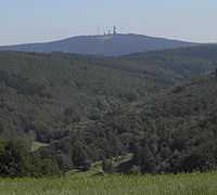
A typical view of the Hunsrück countryside
-

Balduinseck ruins between Mastershausen and Buch
External links
| |||||||

