Humenné
| Humenné | |
| Town | |
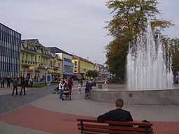 A square in Humenné | |
| Country | Slovakia |
|---|---|
| Region | Prešov |
| District | Humenné |
| Tourism region | Horný Zemplín |
| River | Laborec |
| Elevation | 156 m (512 ft) |
| Coordinates | 48°56′09″N 21°54′24″E / 48.93583°N 21.90667°E |
| Area | 28.762 km2 (11 sq mi) |
| Population | 34,916 (31 December 2006) |
| Density | 1,214 / km2 (3,144 / sq mi) |
| First mentioned | 1317 |
| Mayor | Jana Vaľová (Smer - SD) |
| Timezone | CET (UTC+1) |
| - summer (DST) | CEST (UTC+2) |
| Postal code | 066 01 |
| Phone prefix | 421-57 |
| Car plate | HE |
  Location of Humenné in Slovakia
| |
  Location of Humenné in the Prešov Region
| |
| Wikimedia Commons: Humenné | |
| Statistics: MOŠ/MIS | |
| Website: http://www.humenne.sk | |
Humenné (![]() pronunciation (help·info); Ukrainian: Гуменне; German: Homenau; Hungarian: Homonna) is a town in the Prešov Region ("kraj") in eastern Slovakia and the second largest town of the historic Zemplín region. It lies at the volcanic Vihorlat mountains and at the confluence of the Laborec and Cirocha Rivers.
pronunciation (help·info); Ukrainian: Гуменне; German: Homenau; Hungarian: Homonna) is a town in the Prešov Region ("kraj") in eastern Slovakia and the second largest town of the historic Zemplín region. It lies at the volcanic Vihorlat mountains and at the confluence of the Laborec and Cirocha Rivers.
Characteristics
Humenné is a center of one of the easternmost districts ("okres") in Slovakia. Its life is rich in cultural and sports events. The town is a starting point for tourism, because there are numerous opportunities in the picturesque countryside of the East Carpathians, though this field still requires an intensification of business activities and funding.
The most attractive places are the Vihorlat Mountains boasting of their Morské oko lake, and the Poloniny (Wooden Carpathians) at the border of Slovakia, Poland, and Ukraine, which are part of the National Park Poloniny. The surroundings of Humenné, with their romantic ruins of medieval castles and an open-air museum of architecture situated in the town park, are a source of knowledge and relaxation.
Castles and mansions in the surroundings of Humenné:
- Brekov Castle (in ruins, 7 km (4 mi) to the southwest )
- Jasenov Castle (in ruins, 3 km (2 mi) to the south)
- Čičava Castle (in ruins, 14 km (9 mi) to the southwest )
- Kamenica nad Cirochou - Classicistic mansion from 1773 (at the moment closed for public, 7 km (4 mi) to the east)
History
The Laborec river and the Carpathian mountains predetermined the development of the town and its surroundings, a silent witness of which has been Vihorlat volcano, at 1,075 m (3,526.90 ft) the highest peak of the Vihorlat mountains. Thanks to its advantageous location and pleasant climate, preconditioned by the neighboring mountains, the town has been an attractive place for people since the Stone Age, which is evidenced by a number of archeological findings. The Slavic forefathers of the Slovaks gradually moved to the basin of Humenné during the great migration of peoples, starting in the 5th century.
An intensive and organized settlement of this area started as late as in the middle of the 13th century, after the Mongol raids. The first written document mentioning Humenné dates back to 1317. The history of Humenné is closely connected with the Drugeth (Drugets, Drugetovci), a distinguished aristocratic family originally from Naples, who, accompanying the king Charles Robert of Anjou, came to the Kingdom of Hungary (Slovakia was part of the Kingdom of Hungary) at the beginning of the 14th century. The Drugeths made Humenné their seat and changed it into the centre of one of the largest feudal dominions in Slovakia. King Matthias Corvinus conferred civic privileges (town status) on the town, which were validated by a seal with coat of arms. At that time, the town was crossed by an important trade route connecting the Kingdom of Hungary with the Kingdom of Poland. Humenné is mentioned among royal customs offices, and later on it received the right of storehousing and supposedly market rights, too. This was also the time of an ever increasing influence of shepherd colonization from Carpatho-Ukraine by the so-called Walachians (Ruthenes, Poles, and Romanians).
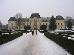
The most significant town monument, a Renaissance castle, was built on the place of an original stone castle in about 1610. The castle came to be an indispensable characteristic feature of the town and serves for museum and cultural purposes at present.
In 1613, during the Counter Reformation, a Jesuit college was established as the first secondary school in the history of Humenné.
In 1619, about 10.000 Polish riders - Lisowczycy, led by Walenty Rogawski, defeated army of George I Rákóczi in Battle of Humenné. Rákóczi was insurgent against Habsburgs and ally of Gábor Bethlen, Duke of Transylvania.
The Drugeth line died out in 1684 and new feudal lords moved in, notably the Csakys and the Wandernats.
The abolition of some feudal duties and the reforms of Maria Theresa promoted the development of crafts, and Humenné became the seat of the so-called "salt office". The town's population consisted of Slovaks, Ruthenes, Hungarians and Jews. Latin was used as the administrative language, which appeared to be a stabilizing factor in such a mixture of nationalities.
The Andrassy family from Transylvania started to influence the history of Humenné in the 19th century, a period characterized by economic growth. Moreover, many new buildings were erected at that time. The main fields of activities of town inhabitants were agriculture, crafts and trade. The first train appeared in Humenné in 1871, stimulating the development of trade and wood cutting. In 1899 the first business academy in Austria-Hungary was established in Humenné. Toward the end of the 19th century, Humenné counted 4,000 inhabitants.
The 20th century brought along a cultural revival. Humenné was famous for its markets and fairs. This promising, though timid, development was interrupted by World War I. A short period of the existence of Czechoslovakia between the two world wars proved to have positive effects upon the life of Humenné. As a corollary of World War II, however, all the effort had to start from the very beginning.
Until 1956 Humenné was an administrative rather than an economic centre. Then the construction of a plant for the production of textile polyamide fibres, the present Chemlon company, triggered a real chain effect on the town's growth. Humenné was gradually becoming a centre of chemical, building, food and mechanical engineering industries. This had a positive impact on the development of technical colleges. The industrial development entailed large-scale housing projects, and the town area was completed by new housing estates. While there were 7,000 inhabitants living in Humenné in 1948, the population now amounts almost 40,000.
Demographics
According to the 2001 census, the town had 35,157 inhabitants. However, along with the surrounding villages that make up the town-ring, Humenné has some 42 thousand inhabitants. 87.80% of inhabitants were Slovaks, 4.84% Rusyns, 3.27% Roma, 2.11% Ukrainian and 0.77% Czechs.[1] The religious makeup was 57.91% Roman Catholics, 23.00% Greek Catholics, 8.69% people with no religious affiliation, 5.91% Orthodox and 0.98% Lutherans.[1]
In 1910, 48.6% were Roman Catholic, 34.8% Jewish, 12.3% Greek Catholic, while 38.2% reported Hungarian as their primary language, 30.8% Slovak and 21.1% Yiddish or German.
Landscape
Notable natives and residents

- Yuri Dojc, Artist and Photographer
- Peter Breiner, pianist, conductor, and composer
- Michal Kováč - first Slovak president in the modern era
- Jozef Tomko, cardinal
- Joachim Jacob Unger, rabbi
- Štefan Babjak, opera singer
- František Kasanič, professional boxer
- Ladislav Grosman, Oscar prize winner
International relations
Twin towns — Sister cities
Humenné is twinned with:
See also
References
- Notes
- ↑ 1.0 1.1 "Municipal Statistics". Statistical Office of the Slovak republic. Archived from the original on 2008-01-11. Retrieved 2008-01-12.
- ↑ "Jarosław Official Website - Partner Cities".
 (in Polish) © 2008 Urząd Miasta Jarosław. Ul. Rynek 1, 37-500 Jarosław. Retrieved 2008-10-23.
External links
- Page of the town Humenné
- UrbanPark - photo project about Humenné
- Childhood Dream - project about community life in Humenné