Hrazdan River
| Hrazdan Հրազդան | |
|---|---|
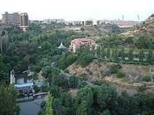 The Hrazdan from below Proshian | |
| Origin | Lake Sevan |
| Mouth | Aras River |
| Basin countries | Armenia |
| Length | 141 km |
| Source elevation | 1097 m |
| Mouth elevation | 826 m |
| Avg. discharge | 17.9 m3/s (632 cu ft/s) |
| Basin area | 2560 km2 (988 sq mi) |
The Hrazdan (Armenian: Հրազդան) is a major river of Armenia. It starts at the northwest extremity of Lake Sevan and flows south through the Province of Kotayk and Armenia's capital, Yerevan. It then joins the Aras River along the border with Turkey. A hydro-electric plant is located on the Hrazdan River. The Hrazdan River is one of Armenia's most important rivers because fishing operations and hydro-electric plants are located along the banks of the river. Moreover, the river's waters are in demand for the irrigation of crops.
Name
In 7th century BC, King Rusa II of Urartu ordered a canal to be dug from the country of Aza (in the Ararat Plain) to Kuera (in the Valley of Kuarlini, now Ejmiatsin). That river was called the Ildarunia in Rusa II’s inscription. Ildarunia was a local ancient name for the Hrazdan River. The name Hrazdan was first mentioned by Movses Khorenatsi as "House of Varuzhanyants in the bank of the Hrazdan River" (Armenian: «Վարուժանյանց տուն՝ Հրազդան գետի ափին»). The Hrazdan River, like the Kasagh River, Metsamor River, Urtsadzor River, and Arpa River, flows to the Araks River. Anania Shirakatsi mentioned the same location of the Hrazdan River with the name Aspahen in his inscription as "Aspahen River that is Khozmor" (Armenian: «Ասպահեն գետ, այսինքն՝ Խոզմոր»). The Aspahen had two names: Metsamor and Khozmor. The suffix –mor means 'swamp'. During the era of Persian influence on Armenian, the name of the river changed. The new name was Phrazdana. The cluster Phr- changed to Hr-, and so the name changed to Hrazdan. Hrazdan also has a popular name as Zangu, which in Armenian means ringing or resonant, an attribute of its rapid and noisy flow.
Gallery


References
- Ալբերտ Փարսադանյան: «Գիտելիքների Շտեմարան-2», էջ 207. «ՎՄՎ-ՊՐԻՆՏ», Երևան, 2005.
See also
- Rivers and lakes in Armenia
- Geography of Armenia
Coordinates: 39°59′25″N 44°27′10″E / 39.99028°N 44.45278°E