Housatonic Range Trail
| Housatonic Range Trail | |
|---|---|
 Footbridge over Morrisey Brook on Housatonic Range Trail, Gaylordsville section of New Milford, Connecticut. | |
| Length | 6.2 mi (10 km) |
| Location | New Milford and Gaylordsville Connecticut |
| Designation | CFPA Blue-Blazed Trail |
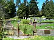
| Trailheads | Candlewood Mountain summit 41°34′48″N 73°27′11″W / 41.5801°N 73.4531°W; Gaylordsville Cemetery on Gaylord Road in Gaylordsville, Connecticut 41°37′54″N 73°29′00″W / 41.6316°N 73.4832°W |
| Use | hiking, cross-country skiing, snowshoeing, fishing, geocaching, other |
| Elevation | |
| Highest point | Candlewood Mountain summit, 971 ft (296 m) |
| Lowest point | Yellow-dot Spur side trail head on CT-7 near Housatonic River, 350 ft (110 m) |
| Hiking details | |
| Trail difficulty | easy, with some difficult sections (bypass routes available) |
| Sights | Housatonic River, Candlewood Mountain, Tory's Cave, Kelly's Slide and Cave, "Suicide Ledges", "Corkscrew" |
| Hazards | hunters, deer ticks, poison ivy |
The Housatonic Range Trail is a 6.2-mile (10.0 km) Blue-Blazed hiking trail in the Housatonic Valley Region (also known as Greater Danbury) of Litchfield County in the town of New Milford in the Candlewood Mountain and Gaylordsville Connecticut sections.
The trail follows the Housatonic River through private land and land trust (e.g. Weantinoge Heritage Land Trust) parcels. The Housatonic Range Trail is primarily a straight north-south through-hike. The northern end of the trail veers slightly westward away from the Housatonic River.
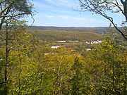
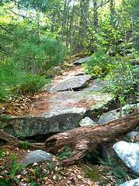
Notable features include the only true cave in Connecticut, an obscured view of the Housatonic River valley, a few modest high points with scenic overlooks (Candlewood Mountain, Kelly's Slide, Pine Knob, Boardman Mountain and the Straits Rock ridge top) as well as many rock formations (including the "Suicide Ledges" and "Corkscrew") and stone fences. There is one segment of the trail which is very close to residential areas.
The Housatonic Range Trail is maintained largely through the efforts of the Connecticut Forest and Park Association.
Trail description

The Housatonic Range Trail is primarily used for hiking, backpacking, picnicking, and in the winter, snowshoeing.
Site-specific activities enjoyed along the route include hunting (very limited), fishing, horseback riding. bouldering, rock climbing and spelunking are ideal activities for experienced practitioners. Almost all of the trail is not suitable for, nor is it used for, cross-country skiing or mountain biking.
The trail is wooded, rocky and has a number of elevation changes except for a very short road walk at the Candlewood Mountain Road and Connecticut Route 37 intersection.
Trail route
The southern terminus of the Housatonic Range Trail is far from parking or a road and is at the summit of Candlewood Mountain in New Milford Connecticut, one and a half miles south of the parking lot and trail head at the junction of CT-37 and Candlewood Mountain Road.
The northern terminus occurs on Gaylord Road in Gaylordsville across from the Gaylordsville Cemetery. There is a very small parking area on Gaylord Street on the cemetery side. The trail soon descends to a wooden foot bridge which crosses a brook.
The Housatonic Range Trail is a north-south "thru-hike" foot path which parallels US Route 7 and the Housatonic River from a distance of approximately one kilometer.
The trail crosses Squash Hollow Road twice in the northern section and the middle section contains a short road walk on Concord Way and Connecticut Route 37 near the trail's intersection with Candlewood Mountain Road.
There are short side trails for trips to Kelly's Slide, Tory's Cave and access/parking on US Route 7 as well as safe bypass routes for the "Corkscrew" and "Suicide Ledges" rock formations.
Trail communities
The Housatonic Range Trail is entirely contained in New Milford, Connecticut. The south end is in the Candlewood Mountain (and Lake) area. The northern end is in the Gaylordsville area.
Landscape, geology, and natural environment
History and folklore
The Housatonic Range Blue-Blazed Trail was created by the Connecticut Forest and Park Association. The entire trail or sometimes just the section south of Connecticut Route 37 is also often referred to as the Candlewood Mountain Trail.
Origin and name
Housatonic ("usi-a-di-en-uk") is derived from the Mohican phrase "beyond the mountain".[1]
This Housatonic was and is the name of a river which begins in Massachusetts and flow through the western extreme of Massachusetts and Connecticut before turning to the south-east, merging with the Naugatuck River (the largest tributary) in Shelton before emptying into Long Island Sound between Stratford and Milford Connecticut.
The Housatonic Range has also become the unofficial name for the area between New Milford and Gaylordsville near the Housatonic River.
Native Americans traveled the Housatonic and its tributaries extensively for trading, hunting, fishing as well as for their annual summer migration to the Long Island Sound shore and winter migration to inland forests. The Dutch, under Adrian Block, are believed to have been the first Europeans to explore the Housatonic River and quickly establishing seasonal fur trading camps with Native American tribes. They built at least one fort on the Housatonic River. To the chagrin of the Dutch, English settlers on the Connecticut shoreline (in Milford and New Haven) began to trade with the Native American tribes up and down the Housatonic and seized the unoccupied Dutch fort without firing weapons.
The Housatonic Range Trail is believed to follow the route of a Native American trail.
Historic sites

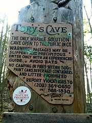
The Tory's Cave is the only natural "marble" true cave (created by water dripping and wearing away rock rather than by upheavals in the earth and rock) in Connecticut.[2] A legend that Tories hid in the cave during the Revolutionary war has no factual basis. The cave is narrow at the opening, parts of it are physically closed off and it is wet inside with parts occupied by bats with "White Nose" disease (one reason it has closed to visitors—The cave was also closed in 2006 for repairs). There is a warning sign outside the cave opening with safety rules including one that only experienced spelunkers should enter it.
There are several public recreational areas close to the Housatonic Range Trail which have historic significance and are worth visiting for visitors to the area.
Candlewood Lake was the first man-made body of water created just for water stored as potential energy. It was created using several dams, one river and water pumped in from the Housatonic River. Today it is the largest lake in Connecticut and a major recreation area. As the average depth of the lake is only forty (40) feet scuba divers can find submerged houses, cars and airplane wrecks.[3]
Candlewood Lake is named after Candlewood Mountain which was named for the bright burning strips of pine which Native Americans taught the early settlers to make as wax candle substitutes.[4]
Squantz Pond State Park and the neighboring Pootatuck State Forest are located on the opposite side of Candlewood Lake from the Housatonic Range Trail.
Lover's Leap State Park at the northern shore of Lake Lillinonah contains many historic ruins and is the legendary location for the suicide leap of Princess Lillinonah.[5]
Hiking the trail

The mainline Housatonic Range trail is blazed with blue rectangles. It is regularly maintained, and is considered easy hiking, with very few sections of rugged and moderately difficult hiking (notably just the climb up to the northern high point near the great Oak tree).
Much of the Housatonic Range Trail is close to water and though some swamp areas inland are prone to flooding the trail along the lake shore is mostly on very high ground. There are no camping facilities along the trail and primitive camping is prohibited in most locations on the route. Trail descriptions are available from a number of commercial and non-commercial sources, and a complete guidebook is published by the Connecticut Forest and Park Association
Weather along the route is typical of Connecticut. This trail does not really have any exposed ridge tops or summits. Snow is common in the winter and may necessitate the use of snowshoes. Ice can form on exposed ledges and summits, making hiking dangerous without special equipment. [6]
Extensive flooding in ponds, puddles and streams usually occurs in the late winter or early spring, overflowing into the trail and causing very muddy conditions. In this case fairly high waterproof boots are recommended. Since some parts of the trail follow forest roads, ruts and tracks from ATVs and four-wheel drive vehicles make be found.
Biting insects can be bothersome during warm weather. Parasitic deer ticks (which are known to carry Lyme disease) are a potential hazard.[7]
Only the northern trail head and the middle of the trail are close to residential areas. There is one very short paved road walk—along CT-37 and Roads. The northern half of the trail crosses two paved roads.
Some parts of the trail is adjacent to, or are on lands where hunting and the use of firearms are permitted. Wearing bright orange clothing during the hunting season (Fall through December) is recommended.
Conservation and maintenance of the trail corridor
Recognition and Inspiration Programs
The closest state forest letterbox to the Housatonic Range Trail is Pootatuck State Forest.[8]
As of April 2010 the Pootatuck State Forest "Seedling Series" letterbox has been missing although the State of Connecticut's Department of Environmental Protection Forestry Division has said that it will be made available again.
See also
- Blue-Blazed Trails
- Candlewood Lake
- Housatonic River
- Housatonic Valley
- Housatonic Valley Region
- Greater Danbury
- Gaylordsville, Connecticut
- New Milford, Connecticut
References
- ↑ http://www.docstoc.com/docs/8412238/Glossary-of-Indian-Place-Name-Roots/
- ↑ http://www.caves.org/grotto/ccg/faq.htm
- ↑ http://www.candlewoodlake.com/candlewoodinfo..html
- ↑ http://www.candlewoodlake.com/candlewoodinfo..html
- ↑ http://www.ct.gov/dep/cwp/view.asp?A=2716&Q=433316
- ↑ http://en.wikipedia.org/wiki/Metacomet_Trail
- ↑ http://en.wikipedia.org/wiki/Metacomet_Trail
- ↑ http://www.ct.gov/DEP/cwp/view.asp?a=2697&q=322864&depNav_GID=1631
External links
Specific Links for this trail:
- Berkshire Hiking Website page on Housatonic Range Trail
- Berkshire Hiking Website page on Tory's Cave
- Gorp Trail Finder Housatonic Range Trail entry
- HikeCT page on the Housatonic Range Trail
- New York/Jersey/Connecticut Botany on Housatonic Range Trail
- MountainZone Candlewood Mountain Summit entry
- MountainZone Kelly's Slide Cliff entry
- MountainZone Pine Knob Summit entry
Government Links (State and Municipal)
- Town of New Milford, Connecticut
- New Milford Historical Society
- Gaylordsville, Connecticut
- Gaylordsville Historical Society
Land Trust and Conservation Organization web sites:
- Connecticut Forest and Park Association
- The Nature Conservancy
- Housatonic Valley Association
- Housatonic Valley Association on New Milford
- Weantinoge Heritage Land Trust
- Weantinoge Heritage Land Trust Facebook
Further reading
- Books – Connecticut Hiking
- Colson, Ann T. (2005). Connecticut Walk Book East (19 ed.). Rockfall, Connecticut: Connecticut Forest and Park Association. pp. 1–261. ISBN 0961905255.
- Colson, Ann T. (2006). Connecticut Walk Book West (19 ed.). Rockfall, Connecticut: Connecticut Forest and Park Association. pp. 1–353. ISBN 0961905263.
- Emblidge, David (1998). Hikes in southern New England: Connecticut, Massachusetts, Vermont (1 ed.). Mechanicsburg, Pennsylvania: Stackpole Books. pp. 1–304. ISBN 0-8117-2669-X.
- Keyarts, Eugene (2002). Pietrzyk, Cindi Dale, ed. Short Nature Walks: Connecticut Guide Book (7 ed.). Guilford, Connecticut: Falcon Publishing. pp. 1–192. ISBN 0-7627-2310-6.
- Laubach, Rene; Smith, Charles W. G. (2007). AMC's Best Day Hikes in Connecticut (1 ed.). Guilford, Connecticut: Appalachian Mountain Club Books. pp. 1–320. ISBN 1-934028-10-X.
- Ostertag, Rhonda; Ostertag, George (2002). Hiking Southern New England (2 ed.). Guilford, Connecticut: Falcon Publishing. pp. 1–336. ISBN 0-7627-2246-0.
- Books – Connecticut History and Geography
- De Forest, John (1853). History of the Indians of Connecticut from the earliest known period to 1850. Hartford, Connecticut: Wm. Jas. Hamersley. pp. 1–509.
- Hayward, John (1857). New England Gazetteer: Containing Descriptions of the States, Counties, Cities and Towns of New England (2 ed.). Boston, Massachusetts: Otis Clapp. pp. 1–704.
- Trumbull, Benjamin (1797). Volume One A Complete History of Connecticut - Civil and Ecclesiastical. Volume I (1818 printing ed.). New Haven, Connecticut: Maltby, Goldsmith & Co. and Samuel Wadsworth. pp. 1–1166.
- Trumbull, Benjamin (1797). Volume Two A Complete History of Connecticut - Civil and Ecclesiastical. Volume II (1818 printing ed.). New Haven, Connecticut: Maltby, Goldsmith & Co. and Samuel Wadsworth. pp. 1–1166.
| |||||||