Houlle
From Wikipedia, the free encyclopedia
| Houlle | |
|---|---|
 Houlle | |
|
Location within Nord-Pas-de-Calais region  Houlle | |
| Coordinates: 50°47′48″N 2°10′25″E / 50.7967°N 2.1736°ECoordinates: 50°47′48″N 2°10′25″E / 50.7967°N 2.1736°E | |
| Country | France |
| Region | Nord-Pas-de-Calais |
| Department | Pas-de-Calais |
| Arrondissement | Saint-Omer |
| Canton | Saint-Omer-Nord |
| Intercommunality | communauté d'agglomération de Saint-Omer |
| Government | |
| • Mayor (2001–2008) | Bernard Rebena |
| Area | |
| • Land1 | 6.52 km2 (2.52 sq mi) |
| Population (2006) | |
| • Population2 | 966 |
| • Population2 Density | 150/km2 (380/sq mi) |
| INSEE/Postal code | 62458 / 62910 |
| Elevation |
0–96 m (0–315 ft) (avg. 7 m or 23 ft) |
|
1 French Land Register data, which excludes lakes, ponds, glaciers > 1 km² (0.386 sq mi or 247 acres) and river estuaries. 2 Population without double counting: residents of multiple communes (e.g., students and military personnel) only counted once. | |
Houlle is a commune in the Pas-de-Calais department in the Nord-Pas-de-Calais region of France.
Geography
A village situated 5 miles (8 km) northwest of Saint-Omer, on the D207 road. "The Houlle" is also the name of a small river close to the village, tributary of the Aa, included in the water management plan (fr:SAGE) of the Audomarois region.
Economy
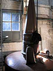
A gin alembic
Population
| Year | 1962 | 1968 | 1975 | 1982 | 1990 | 1999 | 2006 |
|---|---|---|---|---|---|---|---|
| Population | 564 | 657 | 575 | 650 | 864 | 917 | 966 |
| From the year 1962 on: No double counting—residents of multiple communes (e.g. students and military personnel) are counted only once. | |||||||
Places of interest
- The church of St.John the Baptiste, dating from the twelfth century.
- Some 18th century wells.
See also
References
External links
- Website on local products (French)
- Houlle on the Quid website (French)
This article is issued from Wikipedia. The text is available under the Creative Commons Attribution/Share Alike; additional terms may apply for the media files.