Hosingen
From Wikipedia, the free encyclopedia
| Hosingen Housen | ||
|---|---|---|
| Commune | ||
| ||
 | ||
| Country |
| |
| District | Diekirch | |
| Canton | Clervaux | |
| Government | ||
| • Mayor | Jacquot Heinen | |
| Area | ||
| • Total | 45.28 km2 (17.48 sq mi) | |
| Area rank | 7th of 116 | |
| Highest elevation | 535 m (1,755 ft) | |
| • Rank | 10th of 116 | |
| Lowest elevation | 230 m (750 ft) | |
| • Rank | 45th of 116 | |
| Population (2011) | ||
| • Total | 1,827 | |
| • Rank | 63rd of 116 | |
| • Density | 40/km2 (100/sq mi) | |
| • Density rank | 102nd of 116 | |
| Time zone | CET (UTC+1) | |
| • Summer (DST) | CEST (UTC+2) | |
| LAU 2 | LU00001004 | |
| Website | hosingen.lu | |
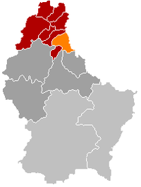
Hosingen (Luxembourgish: Housen) is a small town and former commune in northern Luxembourg. On January 1, 2012, the commune merged with Consthum and Hoscheid communes to form Parc Hosingen commune.
Near Hosingen there is a transmitter for FM and TV of RTL.
As of 2005, the town of Hosingen, which lies in the south of the commune, had a population of 761. Other towns within the commune include Bockholtz, Dorscheid, Neidhausen, Rodershausen, Untereisenbach, Wahlhausen.
| Wikimedia Commons has media related to Hosingen. |
| |||||||
Coordinates: 50°01′N 6°06′E / 50.017°N 6.100°E
This article is issued from Wikipedia. The text is available under the Creative Commons Attribution/Share Alike; additional terms may apply for the media files.

