Hornisgrinde
| Hornisgrinde | |
|---|---|
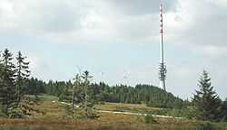 Radio Tower on top of the Hornisgrinde | |
| Elevation | 1,164 m (3,819 ft) |
| Location | |
 Hornisgrinde | |
| Location | Baden-Württemberg, Germany |
| Range | Black Forest |
| Coordinates | 48°36′25″N 8°12′9″E / 48.60694°N 8.20250°ECoordinates: 48°36′25″N 8°12′9″E / 48.60694°N 8.20250°E |
The Hornisgrinde, 1,164 m (3,820 ft), is the highest mountain in the Northern Black Forest of Germany. The Hornisgrinde lies in northern Ortenaukreis district.
Origin of the name
The name is probably derived from Latin, and essentially translates to "swampy head," referring to the Hochmoor. Another interpretation of the name is derived from the terms Horn, miss and grind and meant the same as kahler Bergrücken ("bald ridge"), which carries a moorland on its height.
Geography
The summit of the Hornisgrinde is framed of the Muhrkopf (1003 m) near Unterstmatt in the north and the Mummelsee (1036 m) in the south. In the west the slope is cut through by the Schwarzwaldhochstraße (B 500) in approximately 900 to 1000 m, in the east drops the tendency steeply to the ice-age cirque Biberkessel with the landing Blindsee lake. The summit changes to the Katzenkopf mountain in the southwest at 1123 m, into the southeast drops the burr toward Seibelseckle. The Katzenkopf mountain and the southeast burr of the Hornisgrinde form the cirque of the Mummelsee.
Climate
The Hornisgrinde belongs to the precipitation-richest places in Germany. The average yearly precipitation amounts to 1931 mm. Over 99% of the measuring points of the German weather service indicate lower values. The driest month is February; at most it rains in June. There's 1.4 times more precipitation in the precipitation-richest month than in the driest one. The seasonal precipitation fluctuations lie in the upper third. In over 81% of all places the monthly precipitation varies less.
History

Dreifürstenstein
The Dreifürstenstein is a sandstone plate, which is located at the southeast edge of the plateau. It originates from the year 1722 and marked the border between the Margraviate of Baden, the duchy Württemberg and the Diocese of Strasbourg. Today the point represents the boundary border between Baden's municipalities Sasbach, Seebach and Württemberg's municipality Baiersbronn. With a height of 1,151 m above sea level the Dreifürstenstein is the highest point of Württemberg.[1]
Military use
In 1938 the entire southern range of the summit level was declared as the military restricted area. First being in use since 1942 by the German Forces as an air defense position, the French took over the location in 1945. These operated on the Hornisgrinde an observing station on behalf of the French foreign secret service DGSE. Later the location was used parallel also by the Bundeswehr and NATO. After the plant went out of operation in 1994, it lay fallow several years. The restricted area was released in 1997. In 1999 the neighbor municipalities took over the federal area. Some of the buildings and masts are preserved, however they're purging more and more.
Tourism
Across the ridge the Westweg leads, along the west and south slope runs the Schwarzwaldhochstraße with a large parking lot at the Mummelsee. From there a didactic exhibition with diagrams of the nature protection center Ruhestein leads across the summit level, which crosses the Hochmoor by a wood plank way.

Observation tower
At the southern end, above the Mummelsee, stands the 23 m high Hornisgrindeturm. Its building of 1910 goes back to the initiative of the Schwarzwaldverein association of Baden. New red sandstone was used as building material. Together with the Mummelsee the tower was one of the most popular trip goals of the region at that time. In 1942 it was seized by the Luftwaffe. After World War II the French military used it. In 2000 the forestry association Seebach acquired the tower back from the federation and transferred it to the municipality Seebach into hereditary lease. To May 29, 2005 the tower was opened again for the public.
Signal tower
At the highest point of the mountain, in the midst of the summit level is a further tower, the 7 meters high signal tower established around 1840. In 1892 it was converted by assembly of stairs at the exterior into an observation tower. However, it was inaccessible during the military use of the summit. In 2000 the tower (also called Bismarck tower) was reorganized and made again accessible by a steel spiral stair lying outside.
Winter sports
Alpine
Directly to the Hornisgrinde is no lift system. However, north of the summit is the Skizirkus Unterstmatt, with two lifts at the north slope of the Muhrkopf. In the south the skiing lift Seibelseckle is neighbouring.
Cross-country skiing
Around the summit of the Hornisgrinde leads a 14 km long loipe consisting of the Mummelseeloipe (6 km), Hundsrückenloipe (4.5 km) and the loipe Ochsenstall-Seibelseckle (3.5 km). It is prepared for classical and skating technology. Entrance possibilities are at the Mummelsee, at the col Seibelseckle and at the col Unterstmatt.
Technical plants
- Due to the high average wind speed of 5.2 m/s in the annual average on the Hornisgrinde in the mid-1990s a commercial wind park was established. In 1994 two wind-power plants of 110 KW each one were built in private initiative, a third one with 132 KW followed in 1996. Like on other places there are controversial discusses the exposed location.
- Also on top of the Hornisgrinde is a 206 m (676 ft) high radio tower of the Südwestrundfunk, transmitting radio and television programmes. The tower is not open to the public.
- At the northern end of the summit plateau is a transmitting tower of the German Telekom AG. It accommodates a relay station for amateur television. Until 2005 also the program of the Deutschlandfunk was radiated by this tower, later the transmitter was shifted to the higher and thus far handing SWR tower. Also this tower is not accessible for the public.
References
- ↑ Das ist der Gipfel!. In: Gäubote. September 7th, 2006.